• Link to LinkedIn
  • Link to Youtube
  • Link to Facebook
  • Link to Instagram
  • Link to X
  • Link to Telegram
  • Link to Behance
  • Link to Rss this site
  • Link to Mail
  • NEWS
  • EVENTS
  • JOBS
  • MEMBER
  • Sitemap
    • Home
      • NEWS
      • EVENTS
      • JOBS
      • MEMBERSHIP
    • ⭐ About Geodesy
    • 🏛️ IAG | International Association of Geodesy
      • About IAG
      • Structure
      • 🎓 ECS – Early Career Scientists
      • 🌈 IDEA – Inclusion, Diversity, Equity, Accessibility
    •   └─ Comissions
      • 1️⃣ Reference Frames
      • 2️⃣ Gravity Field
      • 3️⃣ Earth Rotation & Geodynamics
      • 4️⃣ Positioning & Applications
    •   └─ Inter Commission Committees
      • 📚 ICCT – Theory
      • 🌊 ICCM – Marine Research
      • 🌥️ ICCC – Climate Research
    •   └─ Project QuGe
    •   └─ Services
    • 🌍 GGOS | Global Geodetic Observing System
      • About GGOS
      • Structure
      • 🛰️ Observations
      • 📦 Products
      • ⚙️ Services
  • Shopping Cart Shopping Cart
    0Shopping Cart
geodesy.science - IAG website
  • News
    • Home
      • NEWS
      • EVENTS
      • JOBS
      • MEMBERSHIP
    • ⭐ About Geodesy
    • 🏛️ IAG | International Association of Geodesy
      • About IAG
      • Structure
      • 🎓 ECS – Early Career Scientists
      • 🌈 IDEA – Inclusion, Diversity, Equity, Accessibility
    •   └─ Comissions
      • 1️⃣ Reference Frames
      • 2️⃣ Gravity Field
      • 3️⃣ Earth Rotation & Geodynamics
      • 4️⃣ Positioning & Applications
    •   └─ Inter Commission Committees
      • 📚 ICCT – Theory
      • 🌊 ICCM – Marine Research
      • 🌥️ ICCC – Climate Research
    •   └─ Project QuGe
    •   └─ Services
    • 🌍 GGOS | Global Geodetic Observing System
      • About GGOS
      • Structure
      • 🛰️ Observations
      • 📦 Products
      • ⚙️ Services
  • News
    • ALL News
    • 📰 General News
    • 🌍 Geodesy News
    • 📅 Event Update
    • 🏛️ Organisation News
  • Mailing List
  • IAG Newsletter
  • Social Media
  • Post Your News
  • Click to open the search input field Click to open the search input field Search
You are here: Home1 / GGOS2 / UN Science Summit – Africa Rising | Report Geodesy Day
UN Science Summit 2024

UN Science Summit – Africa Rising | Report Geodesy Day

GGOS, Other, 📅 Event Update

Report on the Geodesy Day at the United Nations General Assembly Science Summit 2024

Africa Rising: Shaping our Common Future through Geodesy. Implementing UN General Assembly Resolution A/RES/69/266 “A Global Geodetic Reference Frame for Sustainable Development”

The Science Summit at the UN General Assembly 79  took place from 10 to 27 September 2024 as a hybrid meeting (online and face-to-face in New York City) and coincided with the UN Summit of the Future, which placed a special emphasis on the Africa Science Leadership Coalition, to promote African leadership in science policy decision-making.

The agenda covered a wide range of topics such as multilateral research cooperation, neuroscience and society, water research and innovation, strengthening the central role of science in society, resilient ecosystems and communities with science, transforming knowledge into practical services, and barriers to international science cooperation with a focus on data sharing and management. Amidst all these exciting topics, the 2024 Science Summit hosted a Geodesy Day on 27 September. The one-day session was entitled Africa Rising: Shaping our Common Future through Geodesy. Implementing UN General Assembly Resolution A/RES/69/266 “A Global Geodetic Reference Frame for Sustainable Development”. The main objective of the event was to integrate the African perspective to address unique challenges and contributions by recognising the central role of the global geodesy supply chain in tackling global challenges such as climate change, urbanisation and sustainable resource management, as well as to align geodetic science with policymaking and to advance research through multidisciplinary cooperation within and between African countries. The event was attended by 209 participants and facilitated discussions between Member States, international organisations, and geospatial experts.

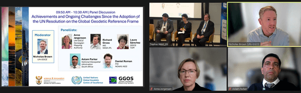
Impressions from the Africa Rising Meeting: On-site panellists: Daniel Roman, Laura Sánchez, Richard Gross, online panellists: Anne Jørgensen, Aslam Parker and Nicholas Brown (moderator), photo M.V. Mackern.

The Geodesy Day was organised by the Department of Science and Innovation (DSI) of South Africa (Aletha de Witt) with the support of the UN Global Geodetic Centre of Excellence – UN-GGCE (Nicholas Brown and Anne Jørgensen) and the Global Geodetic Observing System – GGOS (Laura Sánchez). The opening keynotes highlighted the contribution of geodesy to sustainable development and how geodesy provides the essential reference layer for public infrastructure, as well as the hidden risks that threaten critical infrastructure and sustainable development, with a focus on Africa. Two panel discussions then extended and complemented the views presented in the keynote speeches. The first panel focused on achievements and ongoing challenges since the adoption of the UN Resolution on the GGRF. The second panel discussion focused on African perspectives on the 1st Joint Development Plan for Global Geodesy to sustain the global geodesy supply chain. In the afternoon, the workshop Sustaining the Global Geodesy Supply Chain in Africa provided further insights into the challenges and opportunities of a robust geodetic infrastructure in Africa.

According to the session outcomes, the main opportunities may be summarised as follows:

  • Revitalisation of the African Geodetic Reference Frame (AFREF): Significant efforts are underway to develop a continent-wide geodetic reference network that promotes data consistency and facilitates geospatial applications.
  • Regional cooperation: Initiatives such as the Regional Centre for Mapping of Resources for Development (RCMRD) in Nairobi, the Geospatial Information Section of the UN Economic Commission for Africa (UNECA) in Ethiopia, or the Africa Chapter of the UN Committee of Experts on Global Geospatial Information Management (UN-GGIM Africa) foster geodetic training and capacity building and provide a framework for cooperation at the continental level.
  • Increased participation in global geodetic organisations: The interaction of African scientists and institutions in global communities such as the International Union of Geodesy and Geophysics (IUGG), the International Association of Geodesy (IAG) and the International Federation of Surveyors (FIG) facilitates participation in global initiatives that highlight the essential role of African geodesy in the global framework and promote collaborative projects of mutual benefit.
  • GGOS Africa: The establishment of the GGOS Affiliate GGOS Africa will bring together regional scientists and technicians involved in the collection, analysis, management and use of geodetic data to facilitate greater collaboration across regions, communities and new technologies, and promote geodetic capacity building. This regional alliance will be a powerful tool to identify, enable and develop sustainable geodetic observations, products and services according to regional and national priorities, in line with global goals.

Read the complete report

Laura Sánchez (DGFI-TUM, Germany), Aletha de Witt (DSI, South Africa)

October 2024


📰 Subscribe to "IAG Updates" Mailing List

Get monthly updates on 📰 News, 📅 Events & 💼 Job offers.

No spam! Unsubscribe anytime. By signing up, you agree to our terms.

Also, explore other mailing lists or follow us on social media.

Check your inbox or spam folder to confirm your subscription.

October 27, 2024
October 27, 2024
Share this entry
  • Facebook Facebook Share on Facebook
  • X-twitter X-twitter Share on X
  • Whatsapp Whatsapp Share on WhatsApp
  • Pinterest Pinterest Share on Pinterest
  • Linkedin Linkedin Share on LinkedIn
  • Mail Mail Share by Mail
https://geodesy.science/wp-content/uploads/Africa_Rising_Annoucement_06-EventPage-Copy-Copy-1.png 488 620 Martin Sehnal https://geodesy.science/wp-content/uploads/IAG-logo-web.png Martin Sehnal2024-10-27 05:37:002025-02-05 10:52:22UN Science Summit – Africa Rising | Report Geodesy Day
📰 NEWS

└─ 📰 General News

└─ 🌍 Geodesy News

└─ 🏛️ Organisation News

└─ 📅 Event Update

📢 Latest News

  • Honorary colloquium for Prof. Torge and Prof. Seeber at Leibniz University Hannover
  • Webinar: A Synergy between EUREF and EPOS: GNSS Data Quality Monitoring Service (DQMS)
  • Geodesy Day – International Webinar on Geodesy
  • Geodetic Data: Applying FAIR, TRUST and CARE Principles
  • Geodesy Cartoons – Free Resources for Education and Outreach

✉️ Get Updates Regularly

Mailing List Subscription

Select the list(s) you'd like updates from:

No spam! Unsubscribe anytime. By signing up, you agree to our terms.

Thank you for subscribing! Please check your inbox or spam folder to confirm.

IAG as part of the IUGG

  
The International Association of Geodesy (IAG)  is a constituent association of the International Union of Geodesy and Geophysics (IUGG).

IAG Related Organisations

IAG collaborates closely with numerous organizations within geodesy and beyond. See the list for details.

Sitemap

  • Home | geodesy.science
  • ⠀└─ 📰News
  • ⠀└─ 📅 Events
  • ⠀└─ 💼 Jobs
  • ⠀└─ 👥 Membership
  • ⭐ About Geodesy
  • 🏛️ IAG | Int. Association of Geodesy
  • ⠀└─ ➡️ Commissions:
  • ⠀⠀◻️ 1 – Reference Frames
  • ⠀⠀◻️ 2 – Gravity Field
  • ⠀⠀◻️ 3 – Earth Rotation & Geodynamics
  • ⠀⠀◻️ 4 – Positioning and Applications
  • ⠀└─ 🔀 Inter Commission Committees:
  • ⠀⠀◻️ ICCT – Theory
  • ⠀⠀◻️ ICCM – Marine Research
  • ⠀⠀◻️ ICCC – Climate Research
  • ⠀└─ ⏰ Project QuGe
  • ⠀└─ ⚙️ IAG Services
  •  🌎 GGOS | Observing System
  • ⠀└─ About GGOS
  • ⠀└─ Structure
  • ⠀└─ Observations
  • ⠀└─ Products
  • ⠀└─ Services

References

Geodesy Glossary

Media Library

IAG Cloud | Public Documents

Terms of Use / Privacy Policy

IAG Statutes

IAG By-laws

Contact Us

Contact

Follow Us

LinkedIn

BlueSky

X (Twitter)

Facebook

Instagram

YouTube

Telegram

RSS Feed

Mailing List

This website is provided by the IAG Secretariat and the GGOS Coordinating Office, which are hosted by the BEV – Federal Office of Metrology and Surveying (Bundesamt für Eich- und Vermessungswesen) in Vienna, Austria.

Website Language Translation

The primary language of this website is English – however, the integrated GTranslate tool enables automatic translation into several languages:

Please note that translations into other languages may not be accurate. For reliable information, refer to the English version of the website.

2026 © Copyright | IAG - International Association of Geodesy
  • Link to LinkedIn
  • Link to Youtube
  • Link to Facebook
  • Link to Instagram
  • Link to X
  • Link to Telegram
  • Link to Behance
  • Link to Rss this site
  • Link to Mail
Scroll to top Scroll to top Scroll to top
Accessibility Adjustments

Powered by OneTap

How long do you want to hide the toolbar?
Hide Toolbar Duration
Select your accessibility profile
Vision Impaired Mode
Enhances website's visuals
Seizure Safe Profile
Clear flashes & reduces color
ADHD Friendly Mode
Focused browsing, distraction-free
Blindness Mode
Reduces distractions, improves focus
Epilepsy Safe Mode
Dims colors and stops blinking
Content Modules
Font Size

Default

Line Height

Default

Color Modules
Orientation Modules