 https://geodesy.science/wp-content/uploads/GNSS-and-InSAR-Coseismic-Deformation-in-Venezuela.png
939
1674
Helmut Klima
https://geodesy.science/wp-content/uploads/IAG-logo-web.png
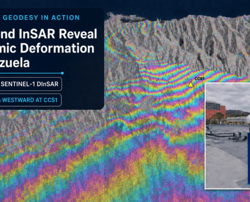
Helmut Klima2026-07-15 09:02:162026-07-15 10:06:27Geodesy in Action: GNSS and InSAR Reveal Coseismic Deformation in Venezuela
https://geodesy.science/wp-content/uploads/GNSS-and-InSAR-Coseismic-Deformation-in-Venezuela.png
939
1674
Helmut Klima
https://geodesy.science/wp-content/uploads/IAG-logo-web.png
Helmut Klima2026-07-15 09:02:162026-07-15 10:06:27Geodesy in Action: GNSS and InSAR Reveal Coseismic Deformation in Venezuela https://geodesy.science/wp-content/uploads/Geodesy-Glossary-AdobeStock_314884997-scaled.jpeg
1471
2560
Martin Sehnal
https://geodesy.science/wp-content/uploads/IAG-logo-web.png
Martin Sehnal2026-06-23 09:00:352026-06-19 12:20:08Geodesy Glossary: A Reference Guide to Geodetic Terminology
https://geodesy.science/wp-content/uploads/Geodesy-Glossary-AdobeStock_314884997-scaled.jpeg
1471
2560
Martin Sehnal
https://geodesy.science/wp-content/uploads/IAG-logo-web.png
Martin Sehnal2026-06-23 09:00:352026-06-19 12:20:08Geodesy Glossary: A Reference Guide to Geodetic Terminology https://geodesy.science/wp-content/uploads/GeodeticData-FAIR-TRUST-CARE_AdobeStock_368854918-1.jpeg
1290
2303
admin
https://geodesy.science/wp-content/uploads/IAG-logo-web.png
admin2026-05-20 09:47:572026-05-20 09:49:15Geodetic Data: Applying FAIR, TRUST and CARE Principles
https://geodesy.science/wp-content/uploads/GeodeticData-FAIR-TRUST-CARE_AdobeStock_368854918-1.jpeg
1290
2303
admin
https://geodesy.science/wp-content/uploads/IAG-logo-web.png
admin2026-05-20 09:47:572026-05-20 09:49:15Geodetic Data: Applying FAIR, TRUST and CARE Principles

 https://geodesy.science/wp-content/uploads/Hobart12_Copyright-DavidSchunckUTAS_2026-02-24_78c49e.JPG
1080
1920
admin
https://geodesy.science/wp-content/uploads/IAG-logo-web.png
admin2026-02-24 12:34:222026-02-24 14:08:28New Website: Discover the Importance of VLBI for Geodesy and Society
https://geodesy.science/wp-content/uploads/Hobart12_Copyright-DavidSchunckUTAS_2026-02-24_78c49e.JPG
1080
1920
admin
https://geodesy.science/wp-content/uploads/IAG-logo-web.png
admin2026-02-24 12:34:222026-02-24 14:08:28New Website: Discover the Importance of VLBI for Geodesy and Society
 https://geodesy.science/wp-content/uploads/GeodesyCartoon_SLRstation_EN_v1-scaled.jpg
2048
1845
admin
https://geodesy.science/wp-content/uploads/IAG-logo-web.png
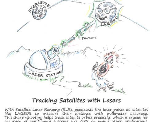
admin2025-08-26 10:44:152025-08-20 11:00:06Satellite Laser Ranging – How SLR Powers Geodesy
https://geodesy.science/wp-content/uploads/GeodesyCartoon_SLRstation_EN_v1-scaled.jpg
2048
1845
admin
https://geodesy.science/wp-content/uploads/IAG-logo-web.png
admin2025-08-26 10:44:152025-08-20 11:00:06Satellite Laser Ranging – How SLR Powers Geodesy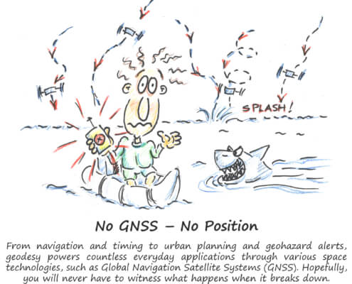 https://geodesy.science/wp-content/uploads/GeodesyCartoon_LostWithoutGeodesy_EN_v1.1-scaled.jpg
2048
1937
Martin Sehnal
https://geodesy.science/wp-content/uploads/IAG-logo-web.png
Martin Sehnal2025-07-21 09:00:202025-07-21 11:30:32Lost Without Geodesy
https://geodesy.science/wp-content/uploads/GeodesyCartoon_LostWithoutGeodesy_EN_v1.1-scaled.jpg
2048
1937
Martin Sehnal
https://geodesy.science/wp-content/uploads/IAG-logo-web.png
Martin Sehnal2025-07-21 09:00:202025-07-21 11:30:32Lost Without Geodesy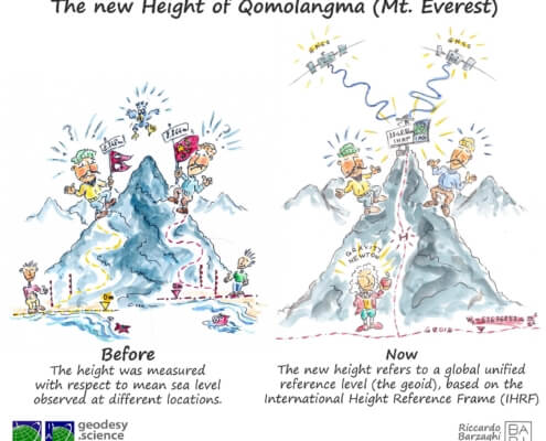 https://geodesy.science/wp-content/uploads/HeightMtEverest_GeodesyCartoon_EN_v2-conflicted-copy-2025-04-10-151229.jpg
1813
2048
admin
https://geodesy.science/wp-content/uploads/IAG-logo-web.png
admin2025-06-12 11:12:102025-06-12 11:12:10First Geodesy Cartoon Released
https://geodesy.science/wp-content/uploads/HeightMtEverest_GeodesyCartoon_EN_v2-conflicted-copy-2025-04-10-151229.jpg
1813
2048
admin
https://geodesy.science/wp-content/uploads/IAG-logo-web.png
admin2025-06-12 11:12:102025-06-12 11:12:10First Geodesy Cartoon Released
