• Link to LinkedIn
  • Link to Youtube
  • Link to Facebook
  • Link to Instagram
  • Link to X
  • Link to Telegram
  • Link to Behance
  • Link to Rss this site
  • Link to Mail
  • NEWS
  • EVENTS
  • JOBS
  • MEMBER
  • Sitemap
    • Home
      • NEWS
      • EVENTS
      • JOBS
      • MEMBERSHIP
    • ⭐ About Geodesy
    • 🏛️ IAG | International Association of Geodesy
      • About IAG
      • Structure
      • 🎓 ECS – Early Career Scientists
      • 🌈 IDEA – Inclusion, Diversity, Equity, Accessibility
    •   └─ Comissions
      • 1️⃣ Reference Frames
      • 2️⃣ Gravity Field
      • 3️⃣ Earth Rotation & Geodynamics
      • 4️⃣ Positioning & Applications
    •   └─ Inter Commission Committees
      • 📚 ICCT – Theory
      • 🌊 ICCM – Marine Research
      • 🌥️ ICCC – Climate Research
    •   └─ Project QuGe
    •   └─ Services
    • 🌍 GGOS | Global Geodetic Observing System
      • About GGOS
      • Structure
      • 🛰️ Observations
      • 📦 Products
      • ⚙️ Services
  • Shopping Cart Shopping Cart
    0Shopping Cart
geodesy.science - IAG website
  • News
    • Home
      • NEWS
      • EVENTS
      • JOBS
      • MEMBERSHIP
    • ⭐ About Geodesy
    • 🏛️ IAG | International Association of Geodesy
      • About IAG
      • Structure
      • 🎓 ECS – Early Career Scientists
      • 🌈 IDEA – Inclusion, Diversity, Equity, Accessibility
    •   └─ Comissions
      • 1️⃣ Reference Frames
      • 2️⃣ Gravity Field
      • 3️⃣ Earth Rotation & Geodynamics
      • 4️⃣ Positioning & Applications
    •   └─ Inter Commission Committees
      • 📚 ICCT – Theory
      • 🌊 ICCM – Marine Research
      • 🌥️ ICCC – Climate Research
    •   └─ Project QuGe
    •   └─ Services
    • 🌍 GGOS | Global Geodetic Observing System
      • About GGOS
      • Structure
      • 🛰️ Observations
      • 📦 Products
      • ⚙️ Services
  • News
    • ALL News
    • 📰 General News
    • 🌍 Geodesy News
    • 📅 Event Update
    • 🏛️ Organisation News
  • Mailing List
  • IAG Newsletter
  • Social Media
  • Post Your News
  • Click to open the search input field Click to open the search input field Search
You are here: Home1 / 🌍 Geodesy News2 / To benefit society and science
earth globe glass hand

To benefit society and science

🌍 Geodesy News
To benefit society and science

“Today we have reached a significant milestone which will benefit society and science and bring global Earth observations to a higher level, said Lars Jacob Hiim, State Secretary to the Norwegian Minister of Local Government and Modernisation, in his opening remarks to more than 150 guests. 

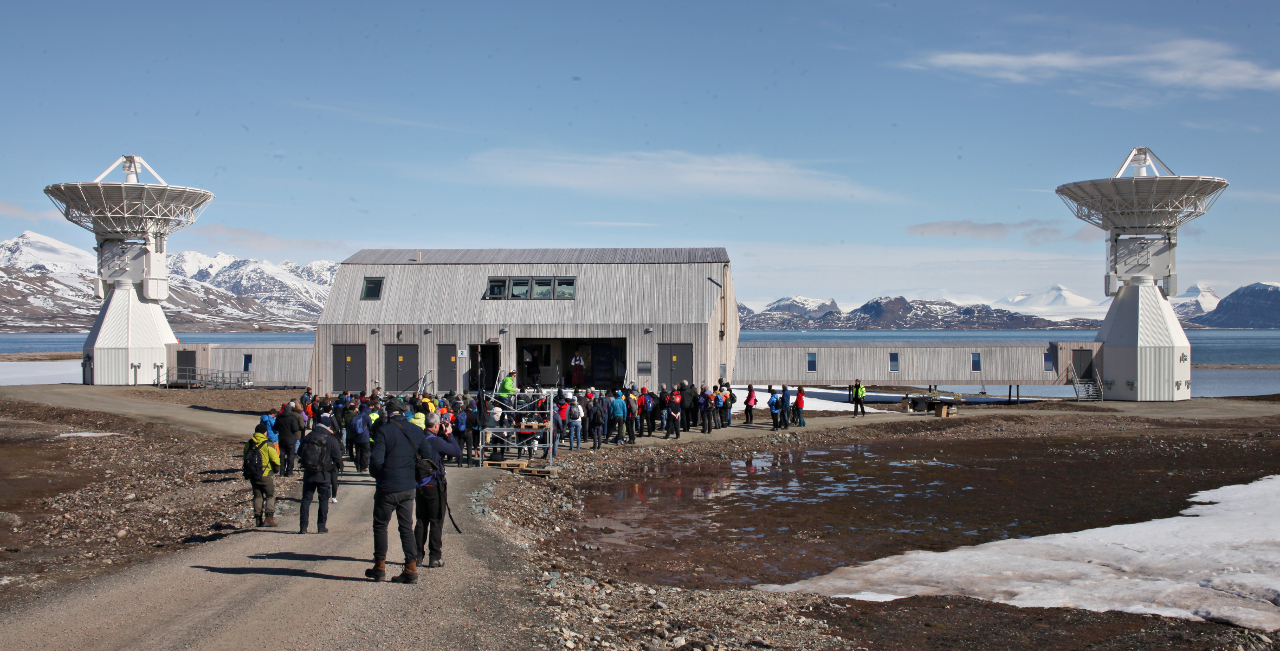
The inauguration of the observatory coincided with the 10th conference of the International VLBI Service for Geodesy and Astrometry, IVS2018 in Longyearbyen, and 110 delegates were invited to participate in the official opening, and were transported to Ny-Ålesund by boat.

“The development of a basic global infrastructure for better Earth observation and for better monitoring of satellites, especially in the High North, is key in order to measure and deal with climate change. It is fundamental for our understanding of sea level change, said Hiim. 

The new VGOS twin telescopes surrounded by the Brandal lagoon, Cape Mitra and Kings Fjord, are impressive. Each antenna measures 13.2 metres in diameter and looms 18 metres above the ground.

“Everyone who’s worked on this project is respectful of the job being done, the environment and surroundings we’re working in – and the fact that we’re delivering something which will contribute to better monitoring of changes to the planet.” says Per Erik Opseth, head of the NMA’s Geodetic Institute.

The NMA’s geodetic Earth observatory is Norway’s most important contribution to the United Nations General Assembly resolution “A Global Geodetic Reference Frame for Sustainable Development.

“Norway takes this work seriously. Together with Australia, we chaired the subcommittee that formulated and negotiated the UN resolution. The time has come to provide stability and commitment to the global collaboration on basic global infrastructure”, said State Secretary Hiim. 

The NMA’s new geodetic Earth observatory ranks as the northernmost facility of its kind and is a cornerstone of the global infrastructure. It has an estimated cost of about NOK 300 million. 

Being delivered by Germany’s MT Mechatronics and its Spanish sub-contractor Asturfeito, the antennas were installed in 2016. Veidekke Arctic was the turnkey contractor for the station site and the new instrumentation building. The first pile was driven in the autumn of 2014. 

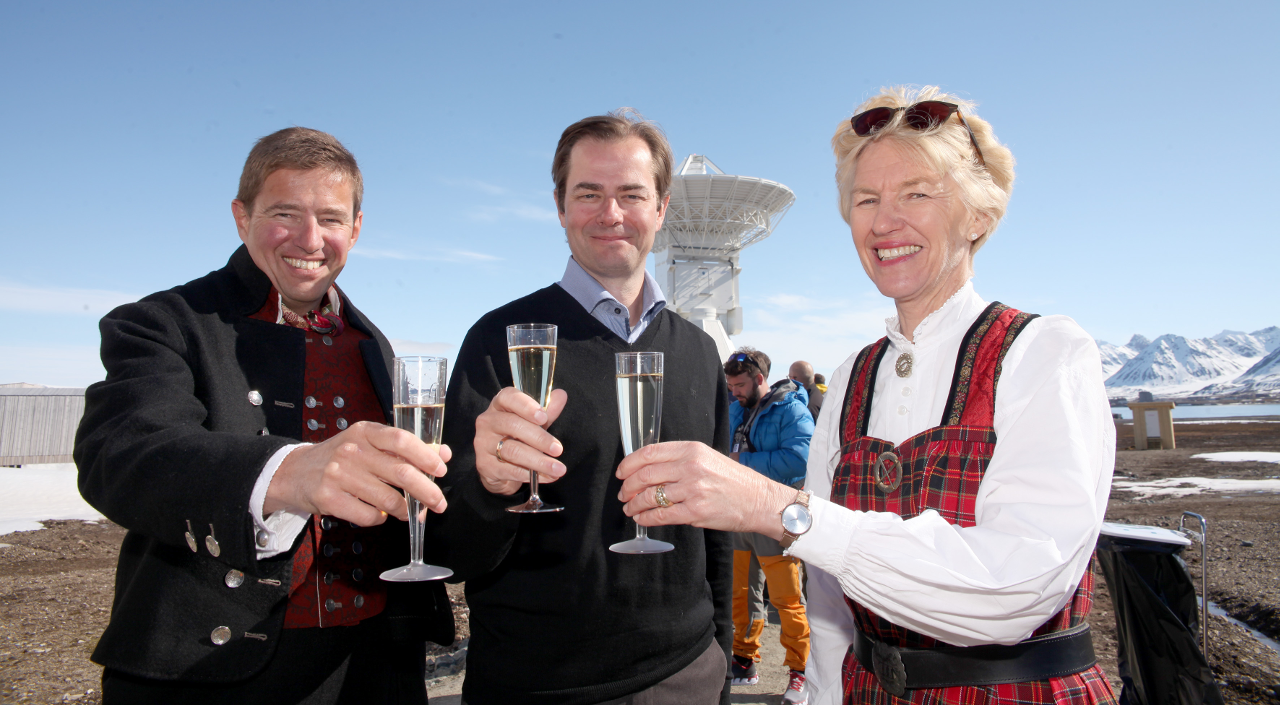
Inaugurating the Earth observatory ( from left: Per Erik Opseth, Head of the Geodetic Institute, NMA. Lars Jacob Hiim, State Secretary to the Minister of Local Government and Modernisation. Anne Cathrine Frøstrup, Director General, NMA, photo: Bjørn-Owe Holmberg)

In August 2017 NASA and NMA signed an agreement to develop a state-of-the-art Satellite Laser Ranging facility. The current goal is to have all systems up and running in Ny-Ålesund by 2022. “An SLR in Ny-Ålesund will be important because it allows us to observe satellites in Polar orbits,” Opseth explains.

Author: text: Anne Jørgensen, Norwegian Mapping Authority photo: Bjørn-Owe Holmberg

📰 Subscribe to "IAG Updates" Mailing List

Get monthly updates on 📰 News, 📅 Events & 💼 Job offers.

No spam! Unsubscribe anytime. By signing up, you agree to our terms.

Also, explore other mailing lists or follow us on social media.

Check your inbox or spam folder to confirm your subscription.

June 27, 2018
June 27, 2018
Share this entry
  • Facebook Facebook Share on Facebook
  • X-twitter X-twitter Share on X
  • Whatsapp Whatsapp Share on WhatsApp
  • Pinterest Pinterest Share on Pinterest
  • Linkedin Linkedin Share on LinkedIn
  • Mail Mail Share by Mail
https://geodesy.science/wp-content/uploads/geodesyNews_AdobeStock_441614817.jpeg 576 1170 admin https://geodesy.science/wp-content/uploads/IAG-logo-web.png admin2018-06-27 00:00:002018-06-27 00:00:00To benefit society and science
📰 NEWS

└─ 📰 General News

└─ 🌍 Geodesy News

└─ 🏛️ Organisation News

└─ 📅 Event Update

📢 Latest News

  • FIG Congress 2026
  • Meet Jorge Martinez – Early Career Scientist
  • Honorary colloquium for Prof. Torge and Prof. Seeber at Leibniz University Hannover
  • Webinar: A Synergy between EUREF and EPOS: GNSS Data Quality Monitoring Service (DQMS)
  • Geodesy Day – International Webinar on Geodesy

✉️ Get Updates Regularly

Mailing List Subscription

Select the list(s) you'd like updates from:

No spam! Unsubscribe anytime. By signing up, you agree to our terms.

Thank you for subscribing! Please check your inbox or spam folder to confirm.

IAG as part of the IUGG

  
The International Association of Geodesy (IAG)  is a constituent association of the International Union of Geodesy and Geophysics (IUGG).

IAG Related Organisations

IAG collaborates closely with numerous organizations within geodesy and beyond. See the list for details.

Sitemap

  • Home | geodesy.science
  • ⠀└─ 📰News
  • ⠀└─ 📅 Events
  • ⠀└─ 💼 Jobs
  • ⠀└─ 👥 Membership
  • ⭐ About Geodesy
  • 🏛️ IAG | Int. Association of Geodesy
  • ⠀└─ ➡️ Commissions:
  • ⠀⠀◻️ 1 – Reference Frames
  • ⠀⠀◻️ 2 – Gravity Field
  • ⠀⠀◻️ 3 – Earth Rotation & Geodynamics
  • ⠀⠀◻️ 4 – Positioning and Applications
  • ⠀└─ 🔀 Inter Commission Committees:
  • ⠀⠀◻️ ICCT – Theory
  • ⠀⠀◻️ ICCM – Marine Research
  • ⠀⠀◻️ ICCC – Climate Research
  • ⠀└─ ⏰ Project QuGe
  • ⠀└─ ⚙️ IAG Services
  •  🌎 GGOS | Observing System
  • ⠀└─ About GGOS
  • ⠀└─ Structure
  • ⠀└─ Observations
  • ⠀└─ Products
  • ⠀└─ Services

References

Geodesy Glossary

Media Library

IAG Cloud | Public Documents

Terms of Use / Privacy Policy

IAG Statutes

IAG By-laws

Contact Us

Contact

Follow Us

LinkedIn

BlueSky

X (Twitter)

Facebook

Instagram

YouTube

Telegram

RSS Feed

Mailing List

This website is provided by the IAG Secretariat and the GGOS Coordinating Office, which are hosted by the BEV – Federal Office of Metrology and Surveying (Bundesamt für Eich- und Vermessungswesen) in Vienna, Austria.

Website Language Translation

The primary language of this website is English – however, the integrated GTranslate tool enables automatic translation into several languages:

Please note that translations into other languages may not be accurate. For reliable information, refer to the English version of the website.

2026 © Copyright | IAG - International Association of Geodesy
  • Link to LinkedIn
  • Link to Youtube
  • Link to Facebook
  • Link to Instagram
  • Link to X
  • Link to Telegram
  • Link to Behance
  • Link to Rss this site
  • Link to Mail
Scroll to top Scroll to top Scroll to top
Accessibility Adjustments

Powered by OneTap

How long do you want to hide the toolbar?
Hide Toolbar Duration
Select your accessibility profile
Vision Impaired Mode
Enhances website's visuals
Seizure Safe Profile
Clear flashes & reduces color
ADHD Friendly Mode
Focused browsing, distraction-free
Blindness Mode
Reduces distractions, improves focus
Epilepsy Safe Mode
Dims colors and stops blinking
Content Modules
Font Size

Default

Line Height

Default

Color Modules
Orientation Modules