SC 2.5: Satellite Altimetry
SC 2.5: Satellite Altimetry
Chair: Xiaoli Deng (Australia)
Vice-Chair: C.K. Shum (USA)
Terms of Reference
Satellite altimetry missions (e.g., Geosat, TOPEX/Poseidon, ERS-1/2, Envisat and Jason-1/2/3) have been providing vital measurements of global ocean surface topography since 1991. The latest altimetry missions (e.g., HY2a/2b, Ka-band altimetry SARAL/Altika, SAR and SARIn altimetry Cry-oSat-2 and Sentinel-3A/B, and laser altimetry ICEsat-2) are providing higher resolution observations. The upcoming Jason-CS/Sentinel-6 mission includes two identical satellites scheduled to launch in 2020 (satellite A) and 2025 (satellite B), which will continue measuring the sea level for at least a decade. The future Surface Water and Ocean Topography (SWOT) satellite mission equipped with radar interferometry, due to launch in 2021, will substantially improve measurements of sea surface heights and surface water hydrology at finer scales; this has not been possible before. In addition, the in situ GNSS reflectometry (GNSS-R) and the NASA CYGNSS 8-satellite constellation have been providing water/sea level, land cover, water/snow extents, wave and wind measurements.
Altimetry observations cover the global oceans, cryosphere, sea-ice, ice-covered oceans and inland water bodies, providing invaluable geodetic and climatic information for studying the Earth and ocean dynamics (e.g., sea level, ocean wave and windspeed, ocean surface topography, tides, soil moisture, snow depth, ice sheet, ice caps,mountain glacier, inland water and solid Earth deformation), and geophysical features (e.g., marine gravity field, mean sea surface and bathymetry).
The growing altimetry datasets are driving technological leaps forward for satellite geodesy and oceanography. At the same time, they will bridge an observational gap on a spatial-temporal domain critical for solving interdisciplinary problems of considerable societal benefit. The purpose of this Sub-commission is to promote innovative research using historic and future altimeter observations to study local, regional,and global geophysical processes, with emphasis on emerging cross-disciplinary appli-cations using satellite altimetry, and in combination with other in situ data sets and techniques including hydrography data, GNSS-R, CYGNSS, SAR/InSAR and GRACE/GOCE.
Objectives
The Sub-Commission 2.5 will:
- Establish a close link with the International Altimeter Service (IAS) and data product providers, in order to (1) establish scientific forums to discuss new results, (2) bring new algorithms from expert research into data production, and (3) encourage development of data products that more directly facilitate cross-disciplinary applications using satellite altimetry.
- Promote innovative applications of satellite altimetry, including evaluations and cross-disciplinary applications of future satellite altimetry.
- Continue developing techniques to improve altimeter data quality, aiming towards the development of new data products across the coastal zones including the coastal ocean, estuaries and inland water bodies.
- Focus on capabilities of the very high spatial resolution from SAR and SARAL altimeters, as well as upcoming SWOT, for precisely modelling the marine gravityfield, mean sea surface, bathymetry and ocean mean dynamic topography, as well as temporal variations induced by solid Earth processes and the global terrestrial water cycle.
- Promote cross-disciplinary research on the shapes and temporal variations of land/ice/ocean surfaces, such as studies of long-term ocean variability, regional and global sea level changes, mountain glaciers/ice-sheet ablations/accumulations, permafrost degradation, coastal and ice-shelf ocean tides, vertical displacements at major tectonic-active zone, land subsidence and other geophysical processes.
Steering Committee
Xiaoli Deng (Australia); Chair
C.K. Shum (USA); Vice-Chair
Ole Andersen (Denmark)
Lifeng Bao (China)
Jérôme Benveniste (Italy)
Denise Dettmering (Germany)
Fukai Peng (China)
Luciana Fenoglio-Marc (Germany)
Cheinway Hwang (China-Taipei)
Hyongki Lee (USA)
Eric Leuliette (USA)
Taoyong Jin (China)
Chungyen Kuo (China-Taipei)
Jürgen Kusche (Germany)
Karina Nielsen (Denmark)
David Sandwell (USA)
Walter Smith (USA)
Stefano Vignudelli (Italy)
Program of Activities
This Sub-commission will:
- Organize independent workshops or special sessions in major meetings to promote altimetric applications in interdisciplinary earth sciences, and to increase the visibility of IAG in altimetric science.
- Provide independent forums for potentially improved altimetry data processing and data product access, to encourage innovative and interdisciplinary scientific research and applications of satellite altimetry.
- Prepare and organize the IAS, currently established as a “Pilot Service”, so that it fulfills the requirements to become a regular IAG Service in the future. This main initiative and activity is described in detail below.
International Altimetry Service (IAS) – Pilot Service
Chair: Xiaoli Deng (Australia)
Vice-Chairs: C.K. Shum (USA), Jérôme Benveniste (Italy), Stefano Vignudelli (Italy)
Executive summary of the opportunity
The IAS Pilot Service, began on 22 July 2023. It was established in preparation for the IAS as a Service of the IAG in the future.
The IAS is to fill the knowledge “gaps” between space agencies and scientific/other users of satellite altimetry data and data products, with the goal of conducting non-duplicated efforts to advance validated alternate altimetry data processing algorithms/analytics towards new data products.
Satellite altimetry has evolved into a unique and operational geodetic remote sensing measurement system with multi-missions and multi-satellite constellations generating an unprecedented climate data record since 1993, for three decades and in the decades to come. Satellite altimetry has fostered seminal research in interdisciplinary Earth sciences, including general ocean circulation, sea-level science, sea-state, global gravity field models (EGMs), bathymetry and marine geophysics, ocean tides, ice reservoir mass change, polar, coastal and oceanography, hydrology and watercycles, low altitude total electronic contents, land and ice digital surface models, near-surface soil moisture, and land surface deformation. Satellite altimetry is deemed to be operational and sustained, contributing to many societal needs, including climate monitoring, meteorological and ocean circulation forecasting, vertical datum realization, maritime safety, ocean pollution tracking services, flood and water resources management, energy and many others.
The significant opportunities below potentially could afford, more than ever, a needfor the establishment of the IAS under the IAG. These opportunities include, but are not limited to, the following:
- Satellite pulse-limited and SAR radar altimetry has been declared mature and operational, with priorities of generating near-real data products for assimilative coastal ocean and wind/wave forecasting, lake meteorological forecasting, and to potentially support disaster response and management.
- High quality satellite radar/laser altimetry missions have been generating global climate and geophysical data. The currently flying (12 satellites) and planned (6satellites) altimetry missions are abundant in the decades to come. The extension ofthe multi-altimetry climate record and its application require collaborations between multiple space agencies, NGOs, and potentially industries, for calibration and validation of multiple onboard instrumentations, and the associated orbital, media, and geophysical corrections, to assess potential inter-mission instrument biases, their drifts, and overall consistency of the interdisciplinary data products, including multi-decadal surface elevation evolutions of ice-sheets, mountain glaciers/ice caps, ice-shelves, sea-/lake-ice, lake/dam water and river levels, and solid Earth deformations.
- Multi-mission and multi-decadal altimetry data records in repeat and geodetic orbital phases contribute significantly to the success of global high-resolution estimates of Earth Gravity Models (EGMs), mean sea surface (MSS), and dynamic ocean topography (DOT) models. The new suite of altimetry mission data willcontinue to improve the next EGM and seafloor bathymetry modelling, and foster innovative geophysical studies.
- Altimetry measurement technology has evolved from pulse-limited Ku-/C-/S-Bandaltimeters to the Ka-Band at the higher sampling rate (1–40 Hz), to the along-track higher resolution SAR and Interferometric altimetry (SARIn) with tunable sampling rates up to 160 Hz and higher with the Fully-Focused SAR (FFSAR) rocessing onboard Sentinel-3/-6, to the multi-beam photon-counting laser altimetry (ATLAS) onboard ICESat-2, to the wide-swath Ka-band radar interferometry (KaRIn) onboard SWOT, and to the planned IRIS (Interferometric radar altimeter for Ice and Snow) Ku/Ka band altimeter onboard CRISTAL, as well as thecurrent and future bistatic radar Signal of Opportunity (SoOP, L-, P-band) altimetry/radiometry/scatterometry missions (e.g., CyGNSS, Spire, Triton, HydroGNSS,PRETTY; P-band: SNoOPI). The L-band GNSS-R bistatic forward scattering radarsignals have been advancing studies of cyclone science and land processes. It is anticipated that the advances in instrument technology will produce finer-scale data products with high accuracy to address interdisciplinary scientific questions and new applications.
Some or majority of the above rationale were articulated to promote the establishment of the IAS over a decade ago. The IAS Planning Group initiated this proposal in 2019 IUGG, Montreal. Based on lessons learnt, a renewed strategy, new innovative technologies, and availability of increased numbers of contemporary satellite altimetry constellations, establishing the IAS Pilot Service as an IAG-ordained Service is thus timely essential.
Background, past actions:
- July 9, 2019: The proposal of re-establishing the IAS was initiated at the IAG Executive Committee meeting in IUGG, Montreal.
- Apr 27, 2022: The ToR of SC2.5.4 – The IAS Planning Group was discussed at the IAG Executive Committee meeting.
- Dec 27, 2022: The revised ToR of SC2.5.4 – The IAS Planning Group was approved at the IAG Executive Committee meeting.
- Apr 27, 2023: The revised ToR of the IAS proposal was discussed at the IAG Executive Committee meeting.
- July 20, 2023: The IAS Pilot Service was approved at the IAG Executive Committee meeting in IUGG, Berlin.
- December 10, 2023: IAS Pilot Service status presented at the IAG Executive Committee meeting
Vision and Purpose
Objectives: The IAS Pilot Service is to bring collaborations together to anticipate and solve geodetic and climate research problems using our satellite altimetry expertise. The broad objective is to provide a service with information about altimetry data, geodetic and climate models, research and operational applications based on satellite altimetry technology innovations. Mechanism of operations will be under IAG structure, with an elected International Governing Board and coordinated peer-reviewed projects.The IAS Pilot Service is to provide a platform for open access to information on satellite altimetry and data distributions for scientific, educational and operational applications. It shall serve users with little experience in satellite altimetry and scientific users with evaluating data, generating new products, models and algorithms. The IAS Pilot Service will:
- establish deliberate bylaws, policy, and rules, and via Call for Participations (CoP)towards establishing IAG Service-Style Coordinating Board, Analysis and Data Centres, and others.
- convene and establish formal dialogs with scientists and key technical curators of existing altimetry data product services to assess the rationales on establishing the IAS Pilot Service that would be mutually beneficial, to IAG IAS, and to theirsponsoring agencies.
- provide a collection of links to altimetry data products, auxiliary information, basic knowledge, models, software tools and physical collections for the benefit of all geodetic/public users.
- provide platform for discussion organized in themes with moderators.
- provide products that are generated using altimetry data archived in the international space agencies, such as AVISO, EUMESAT, JPL, RADS, etc., by IAS analysis and associate centers and members.
- provide users with product descriptions and advice on altimetry data archived in the international space agencies based on IAS members’ altimetry expertise
- provide web services for geodetic and public use that allows access to IAS products, models, results, altimetry-based knowledge and tools.
- provide training courses for scientific users during IAG and IUGG general assemblies.
- organise regular symposia addressing activities carried out at global and regional scales related to the work and objectives of IAS.
- ensure future generations are informed in science, technology and applications ofaltimetry.
Key projects:The IAS Pilot Service (and future IAS) will provide a service to address the key research question: “how new and existing altimetry observations can be used to ensure high-impact solutions of benefit to the geodetic community”. The key here is to provide one place for all information about altimetry data and generated results/models. It will also provide a platform to post questions and answers, which open to a community of registered members and open to everyone but monitored by a moderator.
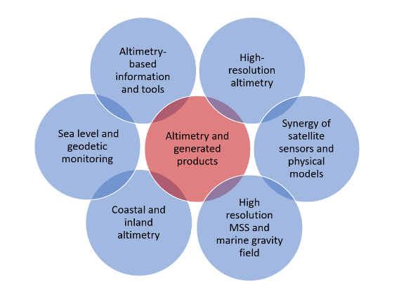
Fig. 1 Key clusters of the IAS
Critical to IAS Pilot Service activities are six clusters (or working groups) based on existing and new study/working groups. Here each cluster is not an isolated mutually exclusive silo, but complements the activities of other clusters (Fig. 1). Clusters can be included in or parallel to IAS Data and Analysis Centres. Each Cluster includes duties such as collecting data and ancillary from space agencies, performing data analysis and validation, providing online availability, and transmittal to and equalization withother Clusters. The set of Clusters provides for open access to IAS data and products by IAS participants and all external users. Clusters are approved by the IAS Pilot Service GB following demonstration of qualifications and commitment. Clusters will provide altimetry data and generated results that have been and will be studied by:
- 1. Sea level and geodetic monitoringIt provides data and results that support studies using altimetry, in situ/SNR and spaceborne GNSS-R altimetry/radiometry for monitoring long-term ocean variability, regional and global sea level changes, inland water bodies, vertical displacementsat major tectonic-active zone, land subsidence and other geophysical processes.
- 2. Altimetry-based information and tools
Chair: Jürgen Kusche (Germany)
It provides altimetry-based knowledge, data, tools and resources for supporting activities for inter-comparisons of processing algorithms and evaluations of dataproducts, as well as new applications of future and other satellite sensors (e.g.,wind/wave fields or ocean/atmosphere coupling application). It will enhance collaborations among scientific users from different IAG commissions, directly facilitating innovative applications and cross-disciplinary applications of satellite altimetry. - 3. Coastal and inland altimetry
Chair: Fukai Peng (China);
Vice-Chair: Stefano Vignudelli (Italy)
It provides auxiliary data and algorithms to produce new products across the coastal zone including coastal ocean, land-sea surface, estuaries and inland water bodies for applications in studies of the extremes, long-term climate change and environmental development. - 4. High-resolution altimetry
Chair: Luciana Fenoglio-Marc (Germany);
Vice-Chair: Ole Baltazar Andersen(Denmark)
This group focuses on high resolution altimetry for geodetic, oceanographic, cryosphere and hydrology studies. It investigates the development allowed by high-resolution altimetry in 1-D and SWOT 2-D fields. It will enhance processing of high-resolution altimetry along-track in SAR mode and comparison of available techniques, and studies in open and coastal oceans, polar oceans and inland waters. - 5. Synergy of satellite sensors and physical models
Chair: Hyongki Lee (USA);
Vice-Chair: Chungyen Kuo (China-Taipei) - This group promotes innovative usage of altimetry data synergistically integrated with data obtained from other satellite sensors (e.g., GNSS-R) and physical models in order to advance scientific studies and real-world applications. It studies geophysical processes from merging multi-mission radar altimetry and laser altimetry (ICESat, ICESat-2), other geodetic data and SWOT interferometric altimetry.
- 6. High resolution MSS and marine gravity field
Chair: David Sandwell (USA);
Vice-Chairs: Ole Andersen (Denmark) and Philippe Schaeffer (France)
This cluster provides a long-term reference sea surface for the physical oceano-graphic and geodetic communities as well as for CAL/VAL of new altimeter missions, and distributes the consensus mean sea surface (MSS) model(s) to the physical oceanography, geodetic, offshore industry, and altimetry communities. It focuses on the development of a MSS for the SWOT mission to provide calibration and validation early in its mission, and on the refinement of the global high-resolution marine gravity field and seafloor bathymetric models.
Products:The IAS Pilot Service collects, archives and distributes altimetry observational datasets of high quality to satisfy the objectives of a wide range of scientific and other high-end applications and experimentation. These data sets are used by the IAS to generate the following products:
- High level data products of long-term ocean variability, sea level and inland waterlevel variations, and land subsidence
- High accuracy sea surface heights in coastal zones
- MSS, marine gravity field and bathymetry models
- High-resolution and high-resolution data products
- Tools and algorithms of new applications of future and other satellite sensors.
Examples of existing products produced by IAS Pilot Service members include:
- ESA Global/Coastal Sea Level/Lakes CCI (https://climate.esa.int/en/projects/sea-level/about/)
- ESA Coastal Altimetry (https://www.coastalaltimetry.org)
- NASA/NOAA PODDAC (https://podaac.jpl.nasa.gov/) Sea Level Portal (https://sealevel.nasa.gov)
- NOAA Real-time Altimetry (https://www.star.nesdis.noaa.gov/socd/lsa/NearRealTime/)
- Aviso/Aviso+(https://www.aviso.altimetry.fr/en/data/products/sea-surface-height-products/global/gridded-sea-level-anomalies-mean-and-climatology.html#c7273)
- University of Houston Jason/Sentinel-3/6 Altimetry Stand-Alone Tool for Earth Research (JASTER_Amirhossein_Feb2024_Final,Sentinel3_Altimetry_Tool_Sep_2023_V2, and Sentinel6_Altimetry_Tool_Oct_2023_V2)
- TUM-DGFI Open Altimeter Database(OpenADB, https://openadb.dgfi.tum.de/en/)
- TUM-DGFI Database for hydrological time series of inland waters (DAHITI, https://dahiti.dgfi.tum.de/en/)
- Scripps global marine gravity field from satellite altimetry (https://topex.ucsd.edu/marine_grav/mar_grav.html)
- Scripps global seafloor topography from satellite altimetry (https://topex.ucsd.edu/WWW_html/mar_topo.html)
- DTU Space mean sea surface, ocean tide and marine gravity models (https://data.dtu.dk)
- Improved coastal altimeter data, retrackers and algorithms by altimetry groups at University of Bonn (Germany), University of Newcastle (Australia), DGFI TUM(Germany), and Tongji University (China), and others.
Engaging with other space agencies as partners: Engagement is already a strong focus of IAS members. IAS will provide a focus that differentiates this service from the “data service” made available by the space agency or each single institute. The goal is to foster and ease the access to each existing platform in a structured way. The expected outcome is to optimise the information-based service already existing and to fill eventual gaps and fix discrepancies. For this interaction with agencies, institutes and other providers is fundamental. A regular seminar series and workshops targeted at key services will be implemented to increase cooperation between the partners. IAS has members from a diverse background in geodesy, geophysics, oceanography, remote sensing disciplines. IAS also has members who sit in altimetry science teams and mission advisory groups, as well as in scientific committees of altimetry communities (e.g., OSTST and coastal altimetry). Members from different IAG commissions and cross-associations provide an opportunity for multi-disciplinary collaborations.
Organization structure
The IAS Pilot Service is to be implemented as a multi-institutional effort. The Joint-Central Bureaus will be set up at The Ohio State University in USA and The University of Newcastle in Australia (for Asia and Pacific regions). The organization consists of the following components:
- Associated members, persons affiliated with contributing organizations that are the electorate body of the IAS Governing Board spend majority of their time on work contributes to the IAS.
- Governing/Coordinating Board (GB), the international body which sets policy and direction for the IAS. Positions are either elected or appointed. The GB is also responsible for the management of IAS restructuring and service activities.
- Central Bureau (CB), functions as the “day-to-day” IAS coordinating body and ensures that IAS Service is made available to the global geodetic community. The CB is responsible for compliance to IAS standards, monitors service operations and quality assurance of products, maintains documentation, organizes meetings and workshops, and coordinates and publishes reports.
- Data and Analysis Centres, analyse the altimetry data to form submissions to IAS products such as sea surface heights, lake/river water surface heights, mean sea surface etc., and provide open access to IAS data and products, and interact with data products provided by space agencies. The centres are committed to submit products for combination into IAS products using designated standards and conventions to meet IAS requirements.
- Clusters, act as working groups via pilot projects with particular focus on components, products, and infrastructural elements within Clusters. Members take responsibility for providing contributions to Cluster’s products and make their expertise available to the Cluster. The GB has power to establish and terminate the Cluster, as well as appoints the chairs of Clusters.
- Executive Committee, comprises of the IAS Chairs and cluster leaders/Chairs, oversees the overall performance and direction of the IAS, ensures the efficient and sustainable pursuit of IAS’ objectives.
- Advisory Board, comprises external members from space agencies and universities which provides advice on data product strategy.
Group Members
At present, the activities for the IAS Pilot Service are carried out by the team ofthe SG 2.5.4 IAS Planning Group, chaired by Xiaoli Deng (Australia). It consists of 32 confirmed members from 11 countries. The IAS Pilot Service is welcoming new members, expecially Early Career Scientists. The members should have aspirations and scientific interest to actively undertake various IAS activities. They may be members of altimetry mission science teams, mission advisory groups, organised interdisciplinary altimetry communities, and stakeholders of new concepts of satellite altimetry and their applications.

