 https://geodesy.science/wp-content/uploads/INGLES-1-1536x1536_Copyright-SIRGAS_2025-09-08.png
1536
1536
admin
https://geodesy.science/wp-content/uploads/IAG-logo-web.png
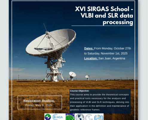
admin2025-09-09 07:28:522025-09-09 07:29:4616th SIRGAS School: “VLBI and SLR Data Processing”
https://geodesy.science/wp-content/uploads/INGLES-1-1536x1536_Copyright-SIRGAS_2025-09-08.png
1536
1536
admin
https://geodesy.science/wp-content/uploads/IAG-logo-web.png
admin2025-09-09 07:28:522025-09-09 07:29:4616th SIRGAS School: “VLBI and SLR Data Processing”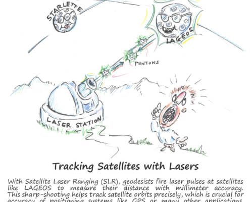 https://geodesy.science/wp-content/uploads/GeodesyCartoon_SLRstation_EN_v1-scaled.jpg
2048
1845
admin
https://geodesy.science/wp-content/uploads/IAG-logo-web.png
admin2025-08-26 10:44:152025-08-20 11:00:06Satellite Laser Ranging – How SLR Powers Geodesy
https://geodesy.science/wp-content/uploads/GeodesyCartoon_SLRstation_EN_v1-scaled.jpg
2048
1845
admin
https://geodesy.science/wp-content/uploads/IAG-logo-web.png
admin2025-08-26 10:44:152025-08-20 11:00:06Satellite Laser Ranging – How SLR Powers Geodesy https://geodesy.science/wp-content/uploads/GIA-workshop-2025.jpg
584
2048
admin
https://geodesy.science/wp-content/uploads/IAG-logo-web.png
admin2025-07-23 09:00:382025-07-23 11:19:00Meeting Summary – Glacial Isostatic Adjustment Workshop 2025
https://geodesy.science/wp-content/uploads/GIA-workshop-2025.jpg
584
2048
admin
https://geodesy.science/wp-content/uploads/IAG-logo-web.png
admin2025-07-23 09:00:382025-07-23 11:19:00Meeting Summary – Glacial Isostatic Adjustment Workshop 2025 https://geodesy.science/wp-content/uploads/VirtualGeodesySchool2025_EN_edited-1.png
1112
1478
admin
https://geodesy.science/wp-content/uploads/IAG-logo-web.png
admin2025-07-21 11:00:582025-07-22 21:13:35Geodesy Virtual School 2025 – Summary
https://geodesy.science/wp-content/uploads/VirtualGeodesySchool2025_EN_edited-1.png
1112
1478
admin
https://geodesy.science/wp-content/uploads/IAG-logo-web.png
admin2025-07-21 11:00:582025-07-22 21:13:35Geodesy Virtual School 2025 – Summary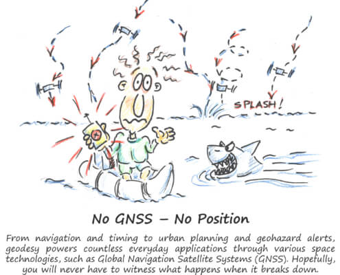 https://geodesy.science/wp-content/uploads/GeodesyCartoon_LostWithoutGeodesy_EN_v1.1-scaled.jpg
2048
1937
Martin Sehnal
https://geodesy.science/wp-content/uploads/IAG-logo-web.png
Martin Sehnal2025-07-21 09:00:202025-07-21 11:30:32Lost Without Geodesy
https://geodesy.science/wp-content/uploads/GeodesyCartoon_LostWithoutGeodesy_EN_v1.1-scaled.jpg
2048
1937
Martin Sehnal
https://geodesy.science/wp-content/uploads/IAG-logo-web.png
Martin Sehnal2025-07-21 09:00:202025-07-21 11:30:32Lost Without Geodesy https://geodesy.science/wp-content/uploads/REFAG_UAW_HP1-scaled.png
778
2048
Martin Sehnal
https://geodesy.science/wp-content/uploads/IAG-logo-web.png
Martin Sehnal2025-06-18 09:53:492025-06-18 11:15:00Call for Abstracts: REFAG2026 – IAG Symposium on Reference Frames for Applications in Geosciences
https://geodesy.science/wp-content/uploads/REFAG_UAW_HP1-scaled.png
778
2048
Martin Sehnal
https://geodesy.science/wp-content/uploads/IAG-logo-web.png
Martin Sehnal2025-06-18 09:53:492025-06-18 11:15:00Call for Abstracts: REFAG2026 – IAG Symposium on Reference Frames for Applications in Geosciences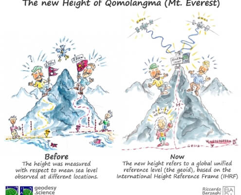 https://geodesy.science/wp-content/uploads/HeightMtEverest_GeodesyCartoon_EN_v2-conflicted-copy-2025-04-10-151229.jpg
1813
2048
admin
https://geodesy.science/wp-content/uploads/IAG-logo-web.png
admin2025-06-12 11:12:102025-06-12 11:12:10First Geodesy Cartoon Released
https://geodesy.science/wp-content/uploads/HeightMtEverest_GeodesyCartoon_EN_v2-conflicted-copy-2025-04-10-151229.jpg
1813
2048
admin
https://geodesy.science/wp-content/uploads/IAG-logo-web.png
admin2025-06-12 11:12:102025-06-12 11:12:10First Geodesy Cartoon Released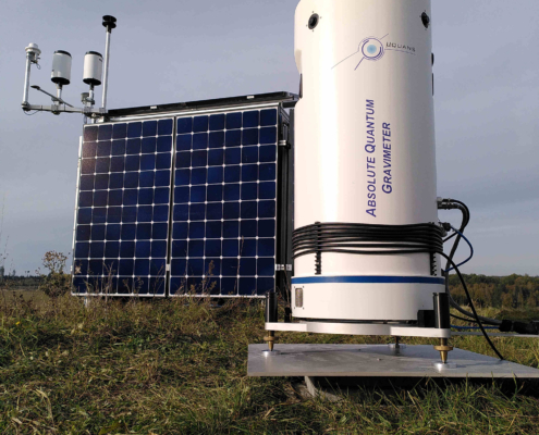 https://geodesy.science/wp-content/uploads/IMG_20231018_161527_mod_Copyright-MarvinReich_2025-06-04-scaled.jpg
2048
1536
admin
https://geodesy.science/wp-content/uploads/IAG-logo-web.png
admin2025-06-05 06:44:312025-06-12 09:15:54New Horizon Europe Project “EQUIP-G” on terrestrial quantum gravimetry
https://geodesy.science/wp-content/uploads/IMG_20231018_161527_mod_Copyright-MarvinReich_2025-06-04-scaled.jpg
2048
1536
admin
https://geodesy.science/wp-content/uploads/IAG-logo-web.png
admin2025-06-05 06:44:312025-06-12 09:15:54New Horizon Europe Project “EQUIP-G” on terrestrial quantum gravimetry https://geodesy.science/wp-content/uploads/startpage-geodesy-science-2025.jpg
884
1110
admin
https://geodesy.science/wp-content/uploads/IAG-logo-web.png
admin2025-06-02 05:28:582025-06-02 05:44:43Welcome to the New IAG Website
https://geodesy.science/wp-content/uploads/startpage-geodesy-science-2025.jpg
884
1110
admin
https://geodesy.science/wp-content/uploads/IAG-logo-web.png
admin2025-06-02 05:28:582025-06-02 05:44:43Welcome to the New IAG Website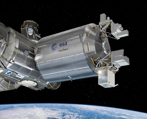 https://geodesy.science/wp-content/uploads/ESA_ACES_on_Columbus.jpg
1375
1750
Martin Sehnal
https://geodesy.science/wp-content/uploads/IAG-logo-web.png
Martin Sehnal2025-05-28 05:53:282025-06-18 12:03:20A new atomic clock in space could help us measure elevations on Earth
https://geodesy.science/wp-content/uploads/ESA_ACES_on_Columbus.jpg
1375
1750
Martin Sehnal
https://geodesy.science/wp-content/uploads/IAG-logo-web.png
Martin Sehnal2025-05-28 05:53:282025-06-18 12:03:20A new atomic clock in space could help us measure elevations on Earth
