 https://geodesy.science/wp-content/uploads/INGLES-1-1536x1536_Copyright-SIRGAS_2025-09-08.png
1536
1536
admin
https://geodesy.science/wp-content/uploads/IAG-logo-web.png
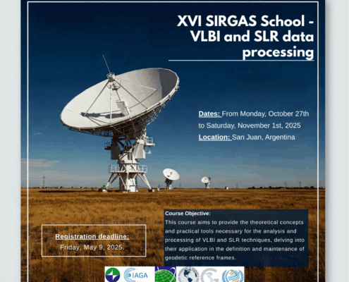
admin2025-09-09 07:28:522025-09-09 07:29:4616th SIRGAS School: “VLBI and SLR Data Processing”
https://geodesy.science/wp-content/uploads/INGLES-1-1536x1536_Copyright-SIRGAS_2025-09-08.png
1536
1536
admin
https://geodesy.science/wp-content/uploads/IAG-logo-web.png
admin2025-09-09 07:28:522025-09-09 07:29:4616th SIRGAS School: “VLBI and SLR Data Processing”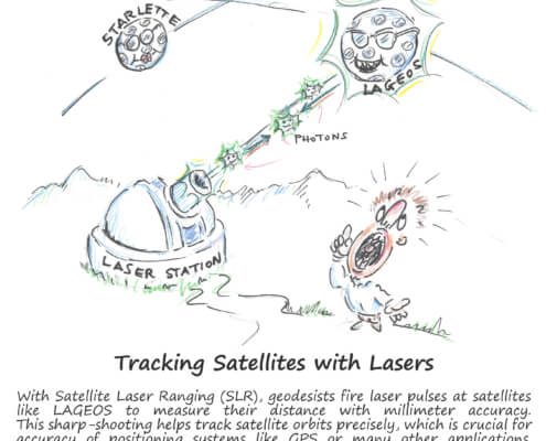 https://geodesy.science/wp-content/uploads/GeodesyCartoon_SLRstation_EN_v1-scaled.jpg
2048
1845
admin
https://geodesy.science/wp-content/uploads/IAG-logo-web.png
admin2025-08-26 10:44:152025-08-20 11:00:06Satellite Laser Ranging – How SLR Powers Geodesy
https://geodesy.science/wp-content/uploads/GeodesyCartoon_SLRstation_EN_v1-scaled.jpg
2048
1845
admin
https://geodesy.science/wp-content/uploads/IAG-logo-web.png
admin2025-08-26 10:44:152025-08-20 11:00:06Satellite Laser Ranging – How SLR Powers Geodesy https://geodesy.science/wp-content/uploads/startpage-geodesy-science-2025.jpg
884
1110
admin
https://geodesy.science/wp-content/uploads/IAG-logo-web.png
admin2025-06-02 05:28:582025-06-02 05:44:43Welcome to the New IAG Website
https://geodesy.science/wp-content/uploads/startpage-geodesy-science-2025.jpg
884
1110
admin
https://geodesy.science/wp-content/uploads/IAG-logo-web.png
admin2025-06-02 05:28:582025-06-02 05:44:43Welcome to the New IAG Website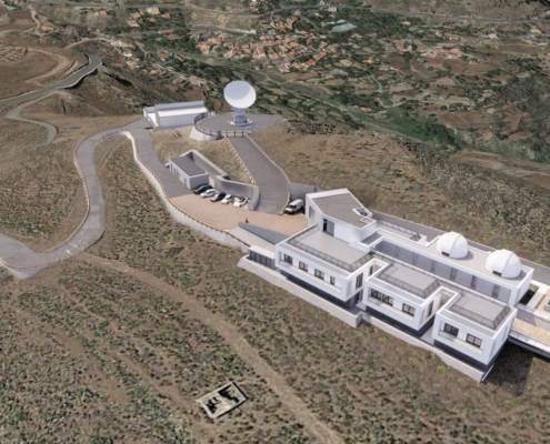 https://geodesy.science/wp-content/uploads/RAEGE_Temisas-1.jpg
872
1417
Martin Sehnal
https://geodesy.science/wp-content/uploads/IAG-logo-web.png
Martin Sehnal2025-03-14 05:57:472025-10-06 12:36:33New RAEGE Station in Gran Canaria: A Milestone for Global Geodesy
https://geodesy.science/wp-content/uploads/RAEGE_Temisas-1.jpg
872
1417
Martin Sehnal
https://geodesy.science/wp-content/uploads/IAG-logo-web.png
Martin Sehnal2025-03-14 05:57:472025-10-06 12:36:33New RAEGE Station in Gran Canaria: A Milestone for Global Geodesy https://geodesy.science/wp-content/uploads/eventNews1_AdobeStock_238163501.jpeg
1004
1504
admin
https://geodesy.science/wp-content/uploads/IAG-logo-web.png
admin2021-09-06 00:00:002025-04-08 05:42:01ILRS Virtual World Tour 2021
https://geodesy.science/wp-content/uploads/eventNews1_AdobeStock_238163501.jpeg
1004
1504
admin
https://geodesy.science/wp-content/uploads/IAG-logo-web.png
admin2019-12-06 00:00:002019-12-06 00:00:00Satellite Laser Ranging School
https://geodesy.science/wp-content/uploads/eventNews1_AdobeStock_238163501.jpeg
1004
1504
admin
https://geodesy.science/wp-content/uploads/IAG-logo-web.png
admin2019-11-06 00:00:002025-04-08 05:43:03Report on the ILRS Technical Workshop 2019
https://geodesy.science/wp-content/uploads/eventNews1_AdobeStock_238163501.jpeg
1004
1504
admin
https://geodesy.science/wp-content/uploads/IAG-logo-web.png
admin2021-09-06 00:00:002025-04-08 05:42:01ILRS Virtual World Tour 2021
https://geodesy.science/wp-content/uploads/eventNews1_AdobeStock_238163501.jpeg
1004
1504
admin
https://geodesy.science/wp-content/uploads/IAG-logo-web.png
admin2019-12-06 00:00:002019-12-06 00:00:00Satellite Laser Ranging School
https://geodesy.science/wp-content/uploads/eventNews1_AdobeStock_238163501.jpeg
1004
1504
admin
https://geodesy.science/wp-content/uploads/IAG-logo-web.png
admin2019-11-06 00:00:002025-04-08 05:43:03Report on the ILRS Technical Workshop 2019 https://geodesy.science/wp-content/uploads/geodesyNews_AdobeStock_441614817.jpeg
576
1170
admin
https://geodesy.science/wp-content/uploads/IAG-logo-web.png
admin2017-08-28 00:00:002017-08-28 00:00:00NASA, Norway to Develop Arctic Laser-Ranging Station
https://geodesy.science/wp-content/uploads/geodesyNews_AdobeStock_441614817.jpeg
576
1170
admin
https://geodesy.science/wp-content/uploads/IAG-logo-web.png
admin2017-08-28 00:00:002017-08-28 00:00:00NASA, Norway to Develop Arctic Laser-Ranging Station
