• Link to LinkedIn
  • Link to Youtube
  • Link to Facebook
  • Link to Instagram
  • Link to X
  • Link to Telegram
  • Link to Behance
  • Link to Rss this site
  • Link to Mail
  • NEWS
  • EVENTS
  • JOBS
  • MEMBER
  • Sitemap
    • Home
      • NEWS
      • EVENTS
      • JOBS
      • MEMBERSHIP
    • ⭐ About Geodesy
    • 🏛️ IAG | International Association of Geodesy
      • About IAG
      • Structure
      • 🎓 ECS – Early Career Scientists
      • 🌈 IDEA – Inclusion, Diversity, Equity, Accessibility
    •   └─ Comissions
      • 1️⃣ Reference Frames
      • 2️⃣ Gravity Field
      • 3️⃣ Earth Rotation & Geodynamics
      • 4️⃣ Positioning & Applications
    •   └─ Inter Commission Committees
      • 📚 ICCT – Theory
      • 🌊 ICCM – Marine Research
      • 🌥️ ICCC – Climate Research
    •   └─ Project QuGe
    •   └─ Services
    • 🌍 GGOS | Global Geodetic Observing System
      • About GGOS
      • Structure
      • 🛰️ Observations
      • 📦 Products
      • ⚙️ Services
  • Shopping Cart Shopping Cart
    0Shopping Cart
geodesy.science - IAG website
  • News
    • Home
      • NEWS
      • EVENTS
      • JOBS
      • MEMBERSHIP
    • ⭐ About Geodesy
    • 🏛️ IAG | International Association of Geodesy
      • About IAG
      • Structure
      • 🎓 ECS – Early Career Scientists
      • 🌈 IDEA – Inclusion, Diversity, Equity, Accessibility
    •   └─ Comissions
      • 1️⃣ Reference Frames
      • 2️⃣ Gravity Field
      • 3️⃣ Earth Rotation & Geodynamics
      • 4️⃣ Positioning & Applications
    •   └─ Inter Commission Committees
      • 📚 ICCT – Theory
      • 🌊 ICCM – Marine Research
      • 🌥️ ICCC – Climate Research
    •   └─ Project QuGe
    •   └─ Services
    • 🌍 GGOS | Global Geodetic Observing System
      • About GGOS
      • Structure
      • 🛰️ Observations
      • 📦 Products
      • ⚙️ Services
  • News
    • ALL News
    • 📰 General News
    • 🌍 Geodesy News
    • 📅 Event Update
    • 🏛️ Organisation News
  • Mailing List
  • IAG Newsletter
  • Social Media
  • Post Your News
  • Click to open the search input field Click to open the search input field Search
You are here: Home1 / GGOS2 / The Importance of Geodetic Reference Frames

The Importance of Geodetic Reference Frames

GGOS, 📰 General News

The International Terrestrial Reference Frame (ITRF) is the standard reference frame recommended by a number of international scientific organizations, including the International Union of Geodesy and Geophysics (IUGG) and the International Association of Geodesy (IAG) for Earth science, satellite navigation and positioning applications.

The ITRF provides the foundation for determining positions on Earth and in space, as well as for reliably quantifying our planet’s changes due to geodynamic processes and ongoing climate change. The ITRF ensures a uniform basis to tackle current and future challenges, including a wide range of location based applications (navigation, traffic and fleet management, transport logistics, control of industrial and agriculture machinery, autonomous driving, …) that now deeply pervade our daily life. A uniform global and long-term stable reference frame is also required for understanding the dynamics of our planet, for monitoring climate change phenomena and for operating early-warning systems to protect against natural hazards.

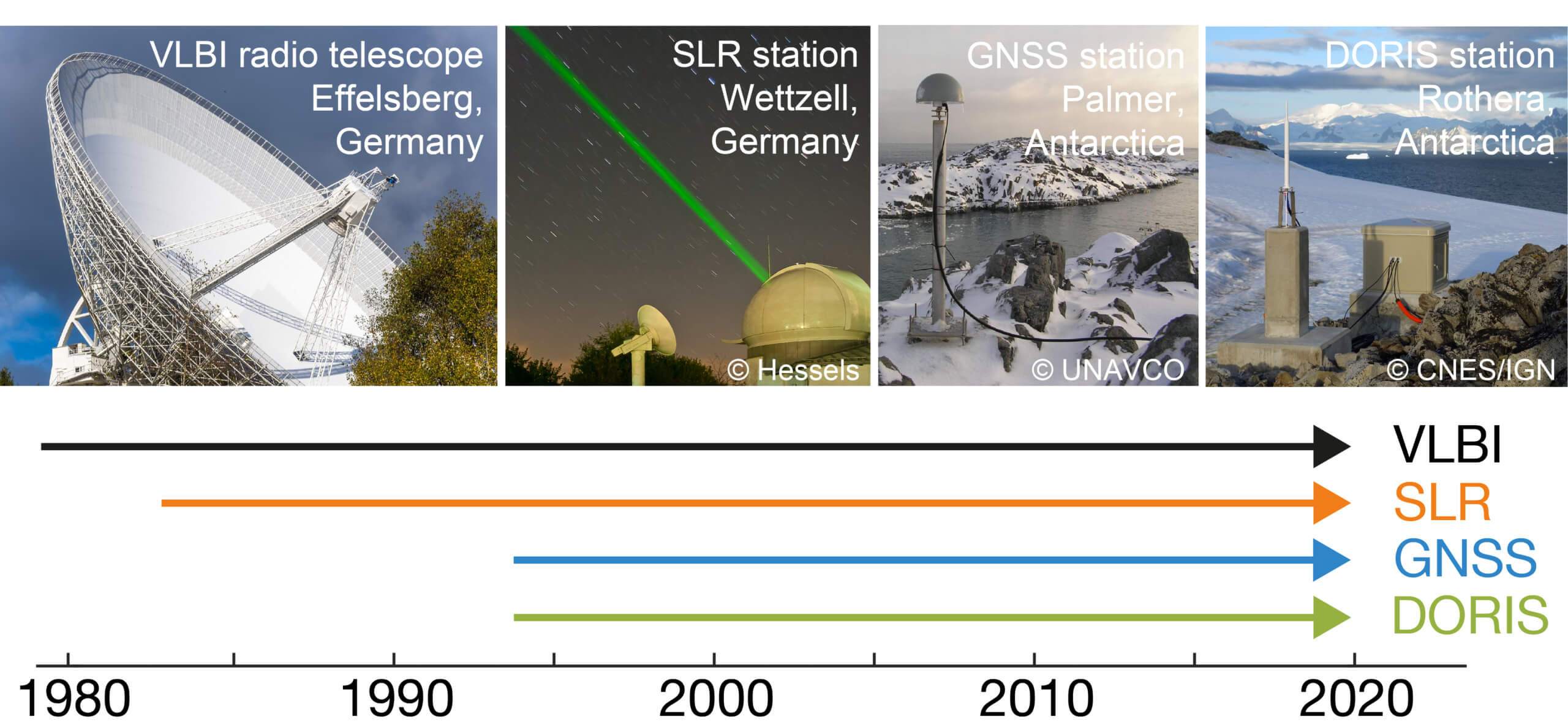
Four space geodetic techniques are currently used for the ITRF computation: Very Long Baseline Interferometry (VLBI), Satellite Laser Ranging (SLR), Global Navigation Satellite Systems (GNSS), and Doppler Orbitography and Radiopositioning Integrated by Satellite (DORIS). These four observation techniques now provide observations over 25 to 40 years.

Figure: Space geodetic techniques VLBI, SLR, GNSS and DORIS and their observation time span used for the realization of the geodetic reference system (Source: DGFI-TUM)

The analysis of the VLBI, SLR, GNSS and DORIS observations over this long time span is a tremendous international effort, which is done by four scientific services (IVS, ILRS, IGS and IDS) of the IAG. The three ITRS Combination Centers of the IERS, namely the Institute national de l’information géographique et forestière (IGN) in Paris, the Deutsches Geodätisches Forschungsinstitut of the Technical University of Munich (DGFI-TUM), and the Jet Propulsion Laboratory (JPL) of NASA in Pasadena, are responsible for the combination of the data provided by the four technique-specific IAG Services. The most recent realization of the International Terrestrial Reference System (ITRS), the ITRF2020, was published on 15 April 2022 (https://itrf.ign.fr/en/solutions/ITRF2020).

More information:

  • GIM International highlights the importance of geodetic reference frames in two articles (see latest issue 7/2023, pp. 43-45 and pp. 77): https://www.gim-international.com/magazines/gim-issue-7-2023
  • Journal of Geodesy article “ITRF2020: an augmented reference frame refining the modeling of nonlinear station motions”:https://doi.org/10.1007/s00190-023-01738-w
  • GGOS Video “Terrestrial Reference Frames – Connecting the World through Geodesy”

Author: Detlef Angermann, Laura Sánchez

Editor: Martin Sehnal

📰 Subscribe to "IAG Updates" Mailing List

Get monthly updates on 📰 News, 📅 Events & 💼 Job offers.

No spam! Unsubscribe anytime. By signing up, you agree to our terms.

Also, explore other mailing lists or follow us on social media.

Check your inbox or spam folder to confirm your subscription.

October 16, 2023
October 16, 2023
Share this entry
  • Facebook Facebook Share on Facebook
  • X-twitter X-twitter Share on X
  • Whatsapp Whatsapp Share on WhatsApp
  • Pinterest Pinterest Share on Pinterest
  • Linkedin Linkedin Share on LinkedIn
  • Mail Mail Share by Mail
https://geodesy.science/wp-content/uploads/TRF-1.jpg 1016 1002 Martin Sehnal https://geodesy.science/wp-content/uploads/IAG-logo-web.png Martin Sehnal2023-10-16 14:16:472025-10-01 12:57:03The Importance of Geodetic Reference Frames
📰 NEWS

└─ 📰 General News

└─ 🌍 Geodesy News

└─ 🏛️ Organisation News

└─ 📅 Event Update

📢 Latest News

  • GGOS Session at AGU26 – Call for Abstracts
  • Geodesy Glossary: A Reference Guide to Geodetic Terminology
  • GGHS2026 – 12-16 October 2026 – New Delhi, India
  • FIG Congress 2026
  • Meet Jorge Martinez – Early Career Scientist

✉️ Get Updates Regularly

Mailing List Subscription

Select the list(s) you'd like updates from:

No spam! Unsubscribe anytime. By signing up, you agree to our terms.

Thank you for subscribing! Please check your inbox or spam folder to confirm.

IAG as part of the IUGG

  
The International Association of Geodesy (IAG)  is a constituent association of the International Union of Geodesy and Geophysics (IUGG).

IAG Related Organisations

IAG collaborates closely with numerous organizations within geodesy and beyond. See the list for details.

Sitemap

  • Home | geodesy.science
  • ⠀└─ 📰News
  • ⠀└─ 📅 Events
  • ⠀└─ 💼 Jobs
  • ⠀└─ 👥 Membership
  • ⭐ About Geodesy
  • 🏛️ IAG | Int. Association of Geodesy
  • ⠀└─ ➡️ Commissions:
  • ⠀⠀◻️ 1 – Reference Frames
  • ⠀⠀◻️ 2 – Gravity Field
  • ⠀⠀◻️ 3 – Earth Rotation & Geodynamics
  • ⠀⠀◻️ 4 – Positioning and Applications
  • ⠀└─ 🔀 Inter Commission Committees:
  • ⠀⠀◻️ ICCT – Theory
  • ⠀⠀◻️ ICCM – Marine Research
  • ⠀⠀◻️ ICCC – Climate Research
  • ⠀└─ ⏰ Project QuGe
  • ⠀└─ ⚙️ IAG Services
  •  🌎 GGOS | Observing System
  • ⠀└─ About GGOS
  • ⠀└─ Structure
  • ⠀└─ Observations
  • ⠀└─ Products
  • ⠀└─ Services

References

Geodesy Glossary

Media Library

IAG Cloud | Public Documents

Terms of Use / Privacy Policy

IAG Statutes

IAG By-laws

Contact Us

Contact

Follow Us

LinkedIn

BlueSky

X (Twitter)

Facebook

Instagram

YouTube

Telegram

RSS Feed

Mailing List

This website is provided by the IAG Secretariat and the GGOS Coordinating Office, which are hosted by the BEV – Federal Office of Metrology and Surveying (Bundesamt für Eich- und Vermessungswesen) in Vienna, Austria.

Website Language Translation

The primary language of this website is English – however, the integrated GTranslate tool enables automatic translation into several languages:

Please note that translations into other languages may not be accurate. For reliable information, refer to the English version of the website.

2026 © Copyright | IAG - International Association of Geodesy
  • Link to LinkedIn
  • Link to Youtube
  • Link to Facebook
  • Link to Instagram
  • Link to X
  • Link to Telegram
  • Link to Behance
  • Link to Rss this site
  • Link to Mail
Scroll to top Scroll to top Scroll to top
Accessibility Adjustments

Powered by OneTap

How long do you want to hide the toolbar?
Hide Toolbar Duration
Select your accessibility profile
Vision Impaired Mode
Enhances website's visuals
Seizure Safe Profile
Clear flashes & reduces color
ADHD Friendly Mode
Focused browsing, distraction-free
Blindness Mode
Reduces distractions, improves focus
Epilepsy Safe Mode
Dims colors and stops blinking
Content Modules
Font Size

Default

Line Height

Default

Color Modules
Orientation Modules