
• Link to LinkedIn
  • Link to Youtube
  • Link to Facebook
  • Link to Instagram
  • Link to X
  • Link to Telegram
  • Link to Behance
  • Link to Rss this site
  • Link to Mail
  • NEWS
  • EVENTS
  • JOBS
  • MEMBER
  • Sitemap
    • Home
      • NEWS
      • EVENTS
      • JOBS
      • MEMBERSHIP
    • ⭐ About Geodesy
    • 🏛️ IAG | International Association of Geodesy
      • About IAG
      • Structure
      • 🎓 ECS – Early Career Scientists
      • 🌈 IDEA – Inclusion, Diversity, Equity, Accessibility
    •   └─ Comissions
      • 1️⃣ Reference Frames
      • 2️⃣ Gravity Field
      • 3️⃣ Earth Rotation & Geodynamics
      • 4️⃣ Positioning & Applications
    •   └─ Inter Commission Committees
      • 📚 ICCT – Theory
      • 🌊 ICCM – Marine Research
      • 🌥️ ICCC – Climate Research
    •   └─ Project QuGe
    •   └─ Services
    • 🌍 GGOS | Global Geodetic Observing System
      • About GGOS
      • Structure
      • 🛰️ Observations
      • 📦 Products
      • ⚙️ Services
  • Shopping Cart Shopping Cart
    0Shopping Cart
geodesy.science - IAG website
  • GGOS
    • Home
      • NEWS
      • EVENTS
      • JOBS
      • MEMBERSHIP
    • ⭐ About Geodesy
    • 🏛️ IAG | International Association of Geodesy
      • About IAG
      • Structure
      • 🎓 ECS – Early Career Scientists
      • 🌈 IDEA – Inclusion, Diversity, Equity, Accessibility
    •   └─ Comissions
      • 1️⃣ Reference Frames
      • 2️⃣ Gravity Field
      • 3️⃣ Earth Rotation & Geodynamics
      • 4️⃣ Positioning & Applications
    •   └─ Inter Commission Committees
      • 📚 ICCT – Theory
      • 🌊 ICCM – Marine Research
      • 🌥️ ICCC – Climate Research
    •   └─ Project QuGe
    •   └─ Services
    • 🌍 GGOS | Global Geodetic Observing System
      • About GGOS
      • Structure
      • 🛰️ Observations
      • 📦 Products
      • ⚙️ Services
  • About
    • About GGOS
      • What is GGOS?
      • Why GGOS?
      • Dual Roles of GGOS
      • Vision and Mission
      • GGOS History
  • Structure
    • Governance & Leadership
      • Governing Board GB
      • Executive Committee EC
    • Coordinating Office CO
    • Science Panel
    • Bureaus
      • BNO – Networks and Observations
      • BPS – Products and Standards
    • Focus Areas
      • Geohazards Monitoring
      • Geodetic Space Weather Research
      • Artificial Intelligence for Geodesy (AI4G)
    • GGOS Affiliates
      • GGOS Japan
      • GGOS D-A-CH
      • GGOS IberAtlantic
    • GGOS Committees & Working Groups
  • Observations
  • Services
  • Products
  • Resources
    • Resources Overview
    • Outreach Materials
    • Logos & Organisation Chart
    • Reports and Articles
    • Presentations and Videos
    • GGOS Meeting Reports
    • Terms of Reference and Strategy
  • Click to open the search input field Click to open the search input field Search
You are here: Home1 / IAG GGOS2 / GGOS Observations3 / ILRS – International Laser Ranging Service

ILRS – International Laser Ranging Service

ILRS laser ranging service iag
Go To Service

Development

The ILRS was established as one of the IAG measurement services in 1998, with a charter to organize and coordinate world-wide Satellite Laser Ranging (SLR) and Lunar Laser Ranging (LLR) activities to support programs in geodesy, geophysics, and lunar and planetary science, and to provide the data products (Earth center of mass and scale) important to the maintenance and improvement of the International Terrestrial Reference Frame (ITRF). The basic observables in SLR/LLR are the precise two-way time-of-flight of an ultra-short laser pulse to a retroreflector array on a satellite or on the surface of the Moon, and the one-way time of flight to a space borne receiver (transponder). These observations enable the computation of precision ephemerides, calibration and performance validation to support active Earth sensing and space science missions (e.g. altimetry, gravity, relativity, etc.) and one-way ranging to support extraterrestrial missions with optical sensors.

The ILRS maintains a comprehensive website as its primary vehicle for the distribution of information for both the ILRS and the outside community at https://ilrs.gsfc.nasa.gov.

ILRS report at the GGOS Days 2023

Data Products

The ILRS SLR data are made available to the community and are also used by the ILRS Analysis Centers to generate fundamental data products, including: accurate satellite ephemerides, Earth orientation parameters, absolute coordinates and velocities of the ILRS tracking stations, temporal variations of the geocenter coordinates, static and time-varying coefficients of Earth’s low-degree gravity field and fundamental physical constants. The ILRS generates a standard product of weekly-averaged station positions and daily resolution Earth orientation parameters that are submitted to the IERS/ITRS daily, and produces LAGEOS and Etalon combinations solutions from several decades of data for maintenance of the ITRF. LLR data are used to generate lunar ephemerides and librations, lunar orientation parameters, and other parameters to describe Earth-Moon dynamics. LLR has also become one of the strongest tools for testing Einstein’s theory of general relativity in the solar system.

See: https://ilrs.gsfc.nasa.gov/data_and_products/products/index.html

Organization

The ILRS organization includes the following permanent components:

  • Tracking Stations (39)
  • Operations Centers (2)
  • Data Centers (3)
  • Analysis Centers (8)
  • Associate Analysis Centers (20)
  • LLR Associate Analysis Centers (6)
  • Analysis Combination Centers (2)
  • Central Bureau
  • Governing Board
  • Standing Committees (5)

Details on these components can be found at: https://ilrs.gsfc.nasa.gov/about/organization/index.html

Service Operations

Satellite Laser Ranging (SLR)

Some satellite missions currently supported by the ILRS; left to right: LAGEOS-1 (credit: NASA), Jason-3 (credit: NASA), a Galileo satellite (credit: ESA), SNET constellation (credit: TU Berlin).

The ILRS Network includes 39 SLR stations; several additional stations are now being established and plan to join the service in the future. Over 100 artificial satellite targets are presently being tracked at LEO, MEO, GNSS, and synchronous altitudes. Large numbers of GNSS satellites (GLONASS, Galileo, BeiDou, QZSS and IRNSS) have been added to the roster; more are expected from the GPS III and other planned GNSS constellations. The LAGEOS, LARES and Etalon satellites are the reference targets for the ITRF; other satellites such as Starlette and Stella are being tested for future contribution to ILRS products.

The network stations provide their data on a routine basis to the CDDIS and the EDC where parallel data files are maintained for access by the users. Stations are expected to meet ILRS data accuracy, quantity, and timeliness standards. Data are regularly analyzed by at least one Analysis or mission-specific Associate Analysis Center. Many of the SLR stations have also been involved with one-way ranging to the Lunar Reconnaissance Orbiter (LRO) and other planetary missions, as well as time transfer activities (e.g., T2L2). In addition, several stations participate in the development, operation and utilization of the space debris laser ranging capabilities for the benefit of space operations and better understanding of satellite re-entry dynamics.

The network continues to operate with a mix of legacy and new technology sites. Many new stations are in the process of development and several stations are also upgrading their systems through the implementation of shorter laser pulse widths, higher pulse repetition rates, new event timers and automation of operations. Significant improvements in station performance has also been achieved through improved satellite center-of-gravity corrections and advances in modeling of systematics. Over the next 5-6 years we expect a significant expansion in global coverage and system performance.

Lunar Laser Ranging (LLR)

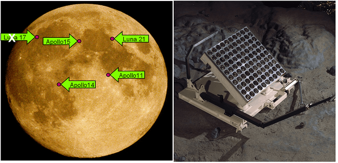
Three laser ranging stations currently range to the five retroreflector arrays on the surface of the Moon. Several additional stations have lunar ranging capability and plan to join the activity. LLR data are collected, archived and distributed under the auspices of ILRS at its data centers, CDDIS and EDC, and made available to users. LLR data have been available on a continuous basis for over 50 years, providing a long continuous time series, albeit from a very limited number of stations.
Publications and Meetings

The ILRS organizes and conducts workshops every one to two years. Workshop sessions cover the applicable and supported science, operations, technology, and software developments. See https://ilrs.gsfc.nasa.gov/about/reports/workshop/index.html for more information on International Workshops on Laser Ranging and ILRS Technical Workshops.

The Governing Board meets biannually. The Central Bureau meets monthly. Most of the ILRS Standing Committees traditionally hold meetings during the workshops and some (e.g. the ASC), at other times during the year as required for the efficient and timely coordination of their activities.

Many ILRS and related publications and reports can be accessed online through the ILRS website including:

  • ILRS annual and multi-year reports
  • ILRS Standing Committee notes/minutes, presentations and reports
  • Science and Engineering references and reports
  • Journal of Geodesy: Special Issue on Satellite Laser Ranging

See: https://ilrs.gsfc.nasa.gov/about/reports/index.html for links to these reports.

Content of this contribution provided by Erricos C. Pavlis, Michael Pearlman, Toshimichi Otsubo, and Carey Noll.


IAG SERVICES

Geometric & General Services

  • IERS iag service earth rotation reference system frame© IERS
    IERS – Int. Earth Rotation and Reference Systems Service
  • IGS iag service gnss global navigation satellite system© IGS
    IGS – International GNSS Service
  • ILRS laser ranging service iag© ILRS
    ILRS – International Laser Ranging Service
  • IVS VLBI Service IAG© IVS
    IVS – International VLBI Service for Geodesy and Astrometry
  • IDS iag service DORIS© IDS
    IDS – International Doris Service
  • PSMSL Permanent Service for Mean Sea Level IAG© PSMSL
    PSMSL – Permanent Service for Mean Sea Level

Gravity Services

  • IGFS iag service gravity field© IGFS
    IGFS – International Gravity Field Service
  • ICGEM iag service© ICGEM
    ICGEM – International Centre for Global Earth Models
  • IDEMS iag service DEM digital elevation model© IDEMS
    IDEMS – International Digital Elevation Model Service
  • IGETS iag service© IGETS
    IGETS – International Geodynamics and Earth Tide Service
  • ISG service geoid IAG© ISG
    ISG – International Service for the Geoid
  • BGI gravimetric service IAG© BGI
    BGI – International Gravimetric Bureau

IAG as part of the IUGG

  
The International Association of Geodesy (IAG)  is a constituent association of the International Union of Geodesy and Geophysics (IUGG).

IAG Related Organisations

IAG collaborates closely with numerous organizations within geodesy and beyond. See the list for details.

Sitemap

  • Home | geodesy.science
  • ⠀└─ 📰News
  • ⠀└─ 📅 Events
  • ⠀└─ 💼 Jobs
  • ⠀└─ 👥 Membership
  • ⭐ About Geodesy
  • 🏛️ IAG | Int. Association of Geodesy
  • ⠀└─ ➡️ Commissions:
  • ⠀⠀◻️ 1 – Reference Frames
  • ⠀⠀◻️ 2 – Gravity Field
  • ⠀⠀◻️ 3 – Earth Rotation & Geodynamics
  • ⠀⠀◻️ 4 – Positioning and Applications
  • ⠀└─ 🔀 Inter Commission Committees:
  • ⠀⠀◻️ ICCT – Theory
  • ⠀⠀◻️ ICCM – Marine Research
  • ⠀⠀◻️ ICCC – Climate Research
  • ⠀└─ ⏰ Project QuGe
  • ⠀└─ ⚙️ IAG Services
  •  🌎 GGOS | Observing System
  • ⠀└─ About GGOS
  • ⠀└─ Structure
  • ⠀└─ Observations
  • ⠀└─ Products
  • ⠀└─ Services

References

Geodesy Glossary

Media Library

IAG Cloud | Public Documents

Terms of Use / Privacy Policy

IAG Statutes

IAG By-laws

Contact Us

Contact

Follow Us

LinkedIn

BlueSky

X (Twitter)

Facebook

Instagram

YouTube

Telegram

RSS Feed

Mailing List

This website is provided by the IAG Secretariat and the GGOS Coordinating Office, which are hosted by the BEV – Federal Office of Metrology and Surveying (Bundesamt für Eich- und Vermessungswesen) in Vienna, Austria.

Website Language Translation

The primary language of this website is English – however, the integrated GTranslate tool enables automatic translation into several languages:

Please note that translations into other languages may not be accurate. For reliable information, refer to the English version of the website.

2026 © Copyright | IAG - International Association of Geodesy
  • Link to LinkedIn
  • Link to Youtube
  • Link to Facebook
  • Link to Instagram
  • Link to X
  • Link to Telegram
  • Link to Behance
  • Link to Rss this site
  • Link to Mail
Scroll to top Scroll to top Scroll to top
Accessibility Adjustments

Powered by OneTap

How long do you want to hide the toolbar?
Hide Toolbar Duration
Select your accessibility profile
Vision Impaired Mode
Enhances website's visuals
Seizure Safe Profile
Clear flashes & reduces color
ADHD Friendly Mode
Focused browsing, distraction-free
Blindness Mode
Reduces distractions, improves focus
Epilepsy Safe Mode
Dims colors and stops blinking
Content Modules
Font Size

Default

Line Height

Default

Color Modules
Orientation Modules
