
• Link to LinkedIn
  • Link to Youtube
  • Link to Facebook
  • Link to Instagram
  • Link to X
  • Link to Telegram
  • Link to Behance
  • Link to Rss this site
  • Link to Mail
  • NEWS
  • EVENTS
  • JOBS
  • MEMBER
  • Sitemap
    • Home
      • NEWS
      • EVENTS
      • JOBS
      • MEMBERSHIP
    • ⭐ About Geodesy
    • 🏛️ IAG | International Association of Geodesy
      • About IAG
      • Structure
      • 🎓 ECS – Early Career Scientists
      • 🌈 IDEA – Inclusion, Diversity, Equity, Accessibility
    •   └─ Comissions
      • 1️⃣ Reference Frames
      • 2️⃣ Gravity Field
      • 3️⃣ Earth Rotation & Geodynamics
      • 4️⃣ Positioning & Applications
    •   └─ Inter Commission Committees
      • 📚 ICCT – Theory
      • 🌊 ICCM – Marine Research
      • 🌥️ ICCC – Climate Research
    •   └─ Project QuGe
    •   └─ Services
    • 🌍 GGOS | Global Geodetic Observing System
      • About GGOS
      • Structure
      • 🛰️ Observations
      • 📦 Products
      • ⚙️ Services
  • Shopping Cart Shopping Cart
    0Shopping Cart
geodesy.science - IAG website
  • GGOS
    • Home
      • NEWS
      • EVENTS
      • JOBS
      • MEMBERSHIP
    • ⭐ About Geodesy
    • 🏛️ IAG | International Association of Geodesy
      • About IAG
      • Structure
      • 🎓 ECS – Early Career Scientists
      • 🌈 IDEA – Inclusion, Diversity, Equity, Accessibility
    •   └─ Comissions
      • 1️⃣ Reference Frames
      • 2️⃣ Gravity Field
      • 3️⃣ Earth Rotation & Geodynamics
      • 4️⃣ Positioning & Applications
    •   └─ Inter Commission Committees
      • 📚 ICCT – Theory
      • 🌊 ICCM – Marine Research
      • 🌥️ ICCC – Climate Research
    •   └─ Project QuGe
    •   └─ Services
    • 🌍 GGOS | Global Geodetic Observing System
      • About GGOS
      • Structure
      • 🛰️ Observations
      • 📦 Products
      • ⚙️ Services
  • About
    • About GGOS
      • What is GGOS?
      • Why GGOS?
      • Dual Roles of GGOS
      • Vision and Mission
      • GGOS History
  • Structure
    • Governance & Leadership
      • Governing Board GB
      • Executive Committee EC
    • Coordinating Office CO
    • Science Panel
    • Bureaus
      • BNO – Networks and Observations
      • BPS – Products and Standards
    • Focus Areas
      • Geohazards Monitoring
      • Geodetic Space Weather Research
      • Artificial Intelligence for Geodesy (AI4G)
    • GGOS Affiliates
      • GGOS Japan
      • GGOS D-A-CH
      • GGOS IberAtlantic
    • GGOS Committees & Working Groups
  • Observations
  • Services
  • Products
  • Resources
    • Resources Overview
    • Outreach Materials
    • Logos & Organisation Chart
    • Reports and Articles
    • Presentations and Videos
    • GGOS Meeting Reports
    • Terms of Reference and Strategy
  • Click to open the search input field Click to open the search input field Search
You are here: Home1 / IAG GGOS2 / Structure3 / Focus Areas4 / Geodetic Space Weather Research

GGOS Focus Area

Geodetic Space Weather Research – GSWR

Introduction

Space weather means today an independent, very up-to-date and interdisciplinary field of research. It describes physical processes in space mainly caused by the Sun’s radiation of energy. The manifestations of space weather are multiple, for instance,

  • variations of the Earth’s magnetic field,
  • polar lights in the northern and southern hemisphere,
  • variations of the upper atmosphere with the compartments magnetosphere, ionosphere and thermosphere (MIT system) (due to coupling processes),
  • solar wind, i.e. the permanent emission of electrons and photons,
  • interplanetary magnetic field,
  • electric currents.

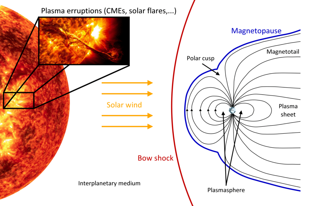
The interplanetary magnetic field (IMF) is the component of the solar magnetic field that is dragged out from the solar corona by the solar wind flow (see Fig. 1).
Michael Schmidt

Michael Schmidt

Chair of FA GSWR (Germany)
geodesy.science - IAG website

E. Forootan

Vice-Chair of FA GSWR
(Denmark)
sun-earth - Geodetic Space Weather Research GGOS Focus Area
© GGOS GSWR - Michael Schmidt Info Info

Figure 1: Scheme for the interaction of the Sun as ionization source and the Earth’s magnetic field, inspired by ESA; for details see Limberger (PhD thesis, TUM, 2015)

The most extreme known space weather event happened on September 1, 1859 – the Carrington storm: a solar coronal mass ejection (CME) hit the Earth’s magnetosphere and induced the largest registered geomagnetic storm. Other prominent recent, but much weaker events have been the Halloween storm on October 28 – 30, 2003, or the St. Patrick’s storm on March 17, 2015. In early February 2022, the poor understanding of thermospheric neutral density changes, caused by unexpected magnetic storms, resulted in the accidental re-entry of 38 Starlink satellites with the cost of more than 10 million EUR. More than 900,000 small debris objects with a radius of at least 1 cm are currently orbiting uncontrolled in the upper atmosphere, which are potential treats to operational satellites. The strength of these events, their impacts on modern society and the possibility of much stronger future events have brought several countries such as US, UK, Japan, Canada, and China to recognize the necessity of studying these impacts scientifically, of developing protection strategies and procedures and to establish space weather data centers and space weather services. Because of these activities the FA-GSWR was initiated.

For a long time, geodesists looked at the ionosphere just as a disturbing factor, whose impacts on electromagnetic signal propagation, i.e. the signal delay and the bending of the ray path, have to be corrected by applying ionospheric correction models of sufficient accuracy. On the other hand, as already mentioned before, the observation data of various geodetic measurement techniques that are influenced by the atmosphere in different ways provide valuable information on state and dynamics of the ionosphere. These are of great interest also for other disciplines such as meteorology.

The following statements summarize the necessity of geodesy to cover scientific research on the coupled processes within the magnetosphere, ionosphere/plasmasphere, and thermosphere (MIT): Geodesy has

  • to deal with the ionosphere and plasmasphere, since the measurements of almost all space-geodetic observation techniques are depending on the charging state of the upper atmosphere, i.e. the ionosphere and plasmasphere,
  • to deal with the thermosphere, since the thermospheric drag is the most important deceleration effect on Low-Earth Orbiting (LEO) satellites and objects in the re-entry stage,
  • to deal with the magnetosphere as it comprises the ionosphere, plasmasphere and thermosphere,
  • a long history and large experience in the development and application of sophisticated analysis techniques and modelling approaches.

Today, for Geodetic Space Weather Research geodesy has to go another step forward by introducing physics. To be more specific, we must consider the complete chain of cause and effect. This means the research has to start with processes and events on the Sun. Next, it has to continue with the effects in the near-Earth space and finally it has to consider the impact on (geodetic) applications and systems. Besides this general chain of cause-and-effect interactions, physics and especially the coupled processes within the MIT system have to be regarded. Geodetic Space Weather Research is fundamental research, too, particularly when intending to detect and to survey structures of the ionosphere, e.g. bubbles, or when studying special phenomena like electro-jets. Summarizing, geodetic space weather research has to be based on

  1. the use and combination of all space geodetic observation methods,
  2. the use of Sun observations,
  3. real-time modelling,
  4. the development of deterministic and stochastic forecast approaches including Machine Learning (ML) algorithms,
  5. assimilation strategies.

Page Navigation

  • IAG GGOS
  •   ─ Structure
  •     ─ Focus Areas
  •        ★ Geodetic Space Weather...
    •             ● Introduction
    •             ● Objectives
    •             ● Joint Study Groups
      •                └─ JSG1 - Understand...
      •                └─ JSG2 - Thermosphe...
      •                └─ JSG 3: Space Weat...
      •                └─ JSG4 - Atmospheri...
    •        ☆ Artificial Intelligenc...
    •        ☆ Unified Height System
    •        ☆ Geohazards Monitoring

News

  • Geodetic Data: Applying FAIR, TRUST and CARE Principles
  • Geodesy Cartoons – Free Resources for Education and Outreach
  • NSL
    Professor Vidal Ashkenazi OBE – Obituary
  • Global Terrestrial Water Storage Anomaly Dataset Now Operationally Available via Copernicus

Join Us!

Join Mailing Lists

Become IAG Member

IAG as part of the IUGG

  
The International Association of Geodesy (IAG)  is a constituent association of the International Union of Geodesy and Geophysics (IUGG).

IAG Related Organisations

IAG collaborates closely with numerous organizations within geodesy and beyond. See the list for details.

Sitemap

  • Home | geodesy.science
  • ⠀└─ 📰News
  • ⠀└─ 📅 Events
  • ⠀└─ 💼 Jobs
  • ⠀└─ 👥 Membership
  • ⭐ About Geodesy
  • 🏛️ IAG | Int. Association of Geodesy
  • ⠀└─ ➡️ Commissions:
  • ⠀⠀◻️ 1 – Reference Frames
  • ⠀⠀◻️ 2 – Gravity Field
  • ⠀⠀◻️ 3 – Earth Rotation & Geodynamics
  • ⠀⠀◻️ 4 – Positioning and Applications
  • ⠀└─ 🔀 Inter Commission Committees:
  • ⠀⠀◻️ ICCT – Theory
  • ⠀⠀◻️ ICCM – Marine Research
  • ⠀⠀◻️ ICCC – Climate Research
  • ⠀└─ ⏰ Project QuGe
  • ⠀└─ ⚙️ IAG Services
  •  🌎 GGOS | Observing System
  • ⠀└─ About GGOS
  • ⠀└─ Structure
  • ⠀└─ Observations
  • ⠀└─ Products
  • ⠀└─ Services

References

Geodesy Glossary

Media Library

IAG Cloud | Public Documents

Terms of Use / Privacy Policy

IAG Statutes

IAG By-laws

Contact Us

Contact

Follow Us

LinkedIn

BlueSky

X (Twitter)

Facebook

Instagram

YouTube

Telegram

RSS Feed

Mailing List

This website is provided by the IAG Secretariat and the GGOS Coordinating Office, which are hosted by the BEV – Federal Office of Metrology and Surveying (Bundesamt für Eich- und Vermessungswesen) in Vienna, Austria.

Website Language Translation

The primary language of this website is English – however, the integrated GTranslate tool enables automatic translation into several languages:

Please note that translations into other languages may not be accurate. For reliable information, refer to the English version of the website.

2026 © Copyright | IAG - International Association of Geodesy
  • Link to LinkedIn
  • Link to Youtube
  • Link to Facebook
  • Link to Instagram
  • Link to X
  • Link to Telegram
  • Link to Behance
  • Link to Rss this site
  • Link to Mail
Scroll to top Scroll to top Scroll to top
Accessibility Adjustments

Powered by OneTap

How long do you want to hide the toolbar?
Hide Toolbar Duration
Select your accessibility profile
Vision Impaired Mode
Enhances website's visuals
Seizure Safe Profile
Clear flashes & reduces color
ADHD Friendly Mode
Focused browsing, distraction-free
Blindness Mode
Reduces distractions, improves focus
Epilepsy Safe Mode
Dims colors and stops blinking
Content Modules
Font Size

Default

Line Height

Default

Color Modules
Orientation Modules


