
GGOS Focus Area
Unified Height System
Establishment of a Global Unified Height Reference System: A GGOS priority
Heights referring to the mean sea level
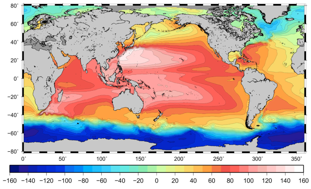
A height (also called altitude or elevation) is the vertical distance between a given object on (or close to) the Earth’s surface and a reference surface. Traditionally, the average (or mean) sea level is used as the reference level, because the sea surface is available worldwide. However, the sea surface has slight hills and valleys in it, similar to the topographic surface although much smoother. Depending on the location, the sea level may be closer to or farther from the centre of the Earth. Thus, the zero elevation as defined by one country differs up to ±2 metres from the zero elevation as defined by other country.
Physical and geometric heights: how the water flows
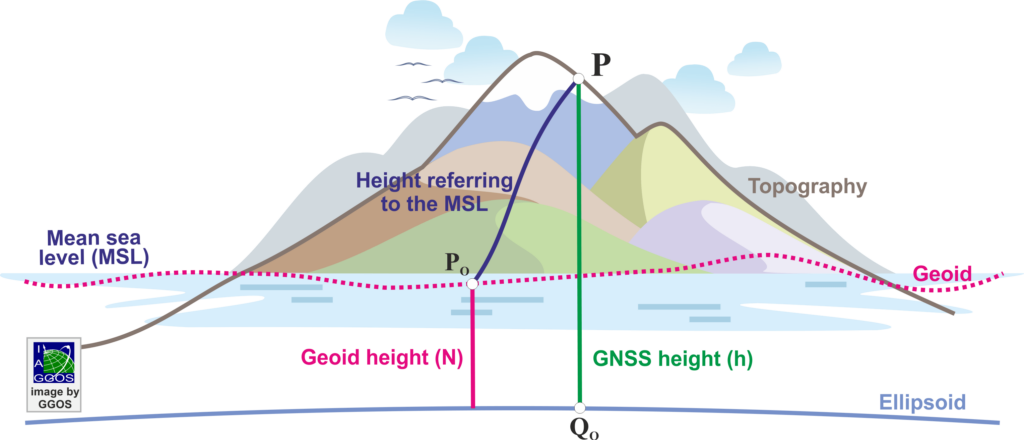
In practice, a variety of techniques and equipment are used to determine heights. However, there is no guarantee that each technique will produce the same height. For instance, heights determined with GNSS (like the US Global Positioning System, the European Galileo, the Russian GLONASS, or the Chinese BeiDou) do not refer to the mean sea surface, but to a geometry model of the Earth called ellipsoid.
Heights referring to the mean sea level describe flow of water and are called physical heights (they depend on the Earth’s gravity field). Heights determined by GNSS do not describe flow of water (the ellipsoidal height of two points located at the same level may be different) and are called geometric heights (they do not depend on the Earth’s gravity field). Differences between GNSS heights and those referring to the mean sea surface may reach up to ±80 m. These differences are represented by the geoid heights. The geoid is a level surface of the Earth’s gravity field acting as reference surface for the determination of physical heights.
Why to make heights consistent?
The state-of-the-art demands an accurate knowledge of the inconsistencies existing between the different heights. For instance, airplanes are equipped with barometric and GNSS navigation systems. Heights provided by the barometric instruments refer to the mean sea level. Heights provided by GNSS refer to the ellipsoid. An airplane approaching for landing, having the wrong height information can have terrible consequences.
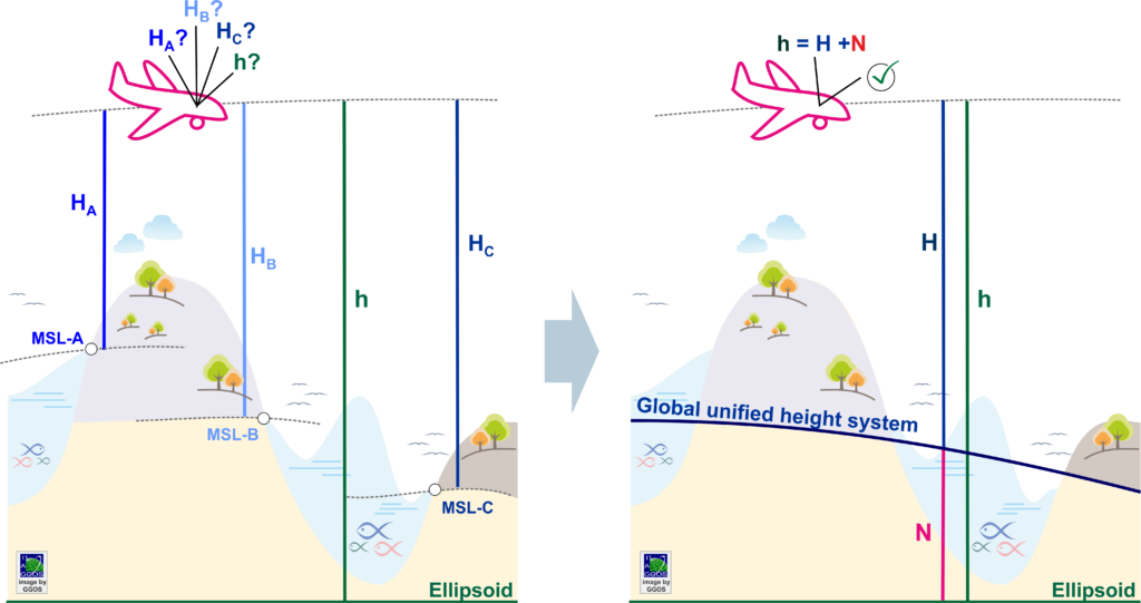
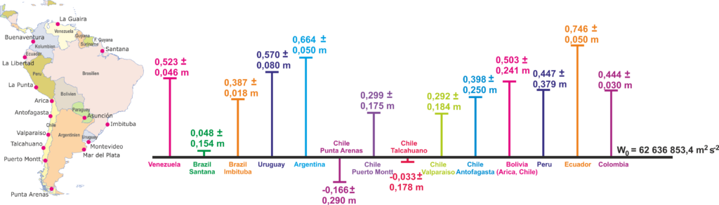
With no conventional global height system definition, most countries today use regional or local height systems, realization of which has been implemented individually, applying in general non-standardized procedures. At present, there are some hundred local and regional physical height systems in use.
They refer to local sea surface levels, are usually stationary (do not consider variations in time), realize different physical height types, and their combination in a global frame presents uncertainties at the metre level. An accurate, consistent and well-defined global vertical reference system that is in accordance with the increased precision of modern observational techniques and is capable of supporting the present needs of science and society regarding geo-referenced data of high resolution has yet to be established as an international standard.
A global unified height system: a priority of GGOS
A global unified height system is needed for all studies or applications requiring a global view of the Earth with measurements not only on land, but over the oceans and ice caps; for instance,
- combination of vertical monitoring in land and ocean areas;
- determination of the correlation between sea level changes and polar ice-cap volume variations;
- combined analysis of satellite-based sea surface monitoring, GNSS positioning, geodetic levelling, and oceanographic procedures for determining sea surface changes over long distances; and
- in general, the monitoring of the System Earth phenomena governed by the gravity field.
From the practical point of view, a global unified physical height system is needed, among others,
- to provide a reliable reference for the accurate connection of national/regional height systems;
- to remove inconsistencies in height-dependent quantities resulting from the use of different local height systems; and
- to support the precise combination of physical and geometric heights in order to exploit at a maximum the advantages of satellite geodesy (e.g. combination of satellite positioning and gravity field models for worldwide unified precise height determination).
The Global Geodetic Observing System (GGOS) of the International Association of Geodesy (IAG), taking care of providing a precise geodetic infrastructure for monitoring the System Earth, promotes the standardization of height systems worldwide by establishing a global unified height system.
GGOS Focus Area – Unified Height System
One initial objective of GGOS was the standardisation of height systems worldwide. In this frame, the GGOS Focus Area Unified Height System (GGOS-FA-UHS) was established in 2010 to lead and coordinate the efforts needed towards the establishment of a global standard for the precise determination of physical heights. The GGOS-FA-UHS activities relied on the contribution of several IAG components, namely, Commission 1 (Reference Frames), Commission 2 (Gravity Field), the Inter-Commission Committee on Theory (ICCT), the International Gravity Field Service (IGFS), and the International Earth’s Rotation and Reference Systems Service (IERS). During the 2011-2015 term, various discussions focused on the best possible definition of a global unified vertical reference system, resulting in the IAG Resolution for the Definition and Realisation of an International Height Reference System (IHRS), which was adopted at the 2015 General Assembly of the International Union of Geodesy and Geophysics (IUGG) in Prague, Czech Republic. During the period 2015-2019, activities were undertaken to investigate the best strategy for the implementation of the IHRS; i.e., the establishment of the International Height Reference Frame (IHRF). A preliminary selection of stations for the IHRF reference network was made and different calculation methods for the determination of potential values as IHRF coordinates were evaluated. For the period 2019-2023, the objectives of the GGOS-FA-UHS focused on:
- compiling detailed standards, conventions, and guidelines to support a consistent determination of the IHRF at global, regional and national levels;
- coordinating with regional/national experts in gravity field modelling the computation of a first IHRF solution; and
- designing an operational infrastructure that will ensure the long-term sustainability and reliability of the IHRF.
With these objectives achieved, the GGOS-FA-UHS completed its goals and was closed during the IUGG 2023 General Assembly in Berlin, Germany. The focus is now on the operational infrastructure required to ensure the maintenance and availability of the IHRS/IHRF in the future. In line with IAG practice, the development of theory and methods for the continuous improvement of the IHRS/IHRF will be continued by the IAG Commissions and the ICCT, while the operational performance will be ensured by the IAG Services, in this particular case the IGFS. From now on, the Central Bureau of the IGFS will continue the lead and coordination activities initiated by the GGOS-FA-UHS in 2010. The central coordinating body for the IHRF comprises individual modules, which take care of the main components of the IHRF. The central management body is the IHRF Coordination Centre and its modules are the IHRF Reference Network Coordination, the IHRF Conventions’ Coordination, the IHRF Associate Analysis Centres and the IHRF Combination Coordination.
IHRF Coordination Centre – More details at http://igfs.topo.auth.gr/
The GGOS-FA-UHS was led by Johannes Ihde (Bundesamt für Kartographie und Geodäsie BKG, Germany) and Michael Sideris (University of Calgary) between 2010 and 2015, and by Laura Sánchez (Deutsches Geodätisches Forschungsinstitut DGFI-TUM, Technische Universität München, Germany) between 2015 and 2023.
Key publications
Sanchez, L., Barzaghi, R. (2024). Achievements of the GGOS Focus Area Unified Height System. In: International Association of Geodesy Symposia. Springer, Berlin, Heidelberg. https://doi.org/10.1007/1345_2024_249
IAG Resolution 2015 for the Definition and Realisation of an International Height Reference System (IHRS). In: Drewes H, Kuglitsch F, Ádám J, Rózsa S (2016). The Geodesist’s Handbook 2016, J Geod 90, page 907, https://doi.org/10.1007/s00190-016-0948-z.
IAG Resolution 2019 for the Establishment of the International Height Reference Frame (IHRF). In: Poutanen M, Rózsa S (2020). The Geodesist’s Handbook 2020. J Geod 94, 109, page 79, https://doi.org/10.1007/s00190-020-01434-z.
Ihde J, Sánchez L, Barzaghi R, Drewes H, Foerste C, Gruber T, Liebsch G, Marti U, Pail R, Sideris M (2017) Definition and proposed realization of the International Height Reference System (IHRS). Surveys in Geophysics, 38(3), 549-570, https://doi.org/10.1007/s10712-017-9409-3.
Sánchez L, Ågren J, Huang J, Wang YM, Mäkinen J, Pail R, Barzaghi R, Vergos GS, Ahlgren K, Liu Q (2021). Strategy for the realisation of the International Height Reference System (IHRS). Journal of Geodesy, 95(3), https://doi.org/10.1007/s00190-021-01481-0.
Sánchez L, Čunderlík R, Dayoub N, Mikula K, Minarechová Z, Šíma Z, Vatrt V, Vojtíšková M (2016) A conventional value for the geoid reference potential W0, J Geod, 90(9): 815-835, https://doi.org/10.1007/s00190-016-0913-x.
Sánchez L, Sideris MG (2017). Vertical datum unification for the International Height Reference System (IHRS). Geophysical Journal International, 209(2), 570-586, https://doi.org/10.1093/gji/ggx025.
Sánchez L, Wziontek H, Wang YM, Vergos G, Timmen L (2023) Towards an integrated global geodetic reference frame: preface to the special issue on reference systems in physical geodesy. Journal of Geodesy, 97(6), https://doi.org/10.1007/s00190-023-01758-6.



