Earth Orientation Parameter
Why are days getting longer and Earth is wobbling?
The Earth Orientation Parameters (EOPs) are the parameters representing the rotational part of the transformation between the International Celestial Reference Frame (ICRF) and the International Terrestrial Reference Frame (ITRF). The EOPs describe the change of the orientation of the Earth’s surface, on which the observatories are located, with respect to a space fixed reference frame. Earth rotation refers to the solid Earth component of the dynamic Earth system excluding deformations, such as tides and continental drift. Through interactions of individual components, angular momentum can be transferred between the atmosphere, ocean, and solid Earth, or between the Earth’s core and mantle due to the coupling mechanisms.
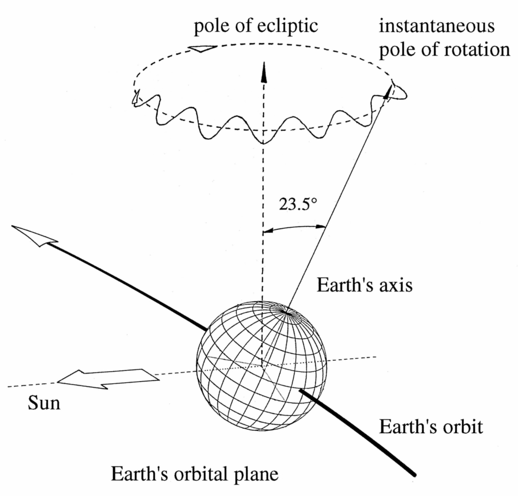
The following examples give an overview of the relevance of the knowledge of accurate Earth orientation parameters:
- Realization of reference frames on Earth and in space
- Precise positioning and satellite navigation
- Precise orbit determination (POD)
- Realization of time systems (e.g. monitoring of the duration of days)
- Earth system science (e.g. climate change)
The transformation between the terrestrial and the celestial reference frames (and vice versa) can be achieved through rotations of three independent angles, provided that the celestial reference system’s origin has been shifted from the barycentre to the geocentre. In this case, it is referred to as the Geocentric Celestial Reference System (GCRS). The three independent angles are given by

Celestial Pole Offset (CPO)
 : Celestial pole offsets (given by Precession, Nutation models) represent the motion of the pole in the celestial system. Precession and nutation can be modelled to a high degree, and only small corrections must be determined by observations. These small corrections are the celestial pole offsets.

Universal Time (UT1)
ERA: Earth Rotation Angle. ERA must be derived from observations of UT1 (Universal Time 1, the primary time standard based on the actual rotation of the Earth). It can also be expressed by the small difference dUT = UT1 – UTC (UTC stands for Coordinated Universal Time).

Length of Day (LOD)
Based on dUT, it is also possible to measure Earth’s exact rotation period compared to a standard 24-hour day (86,400 seconds), i.e. the Length of Day (LOD).

Polar Motion (PM)
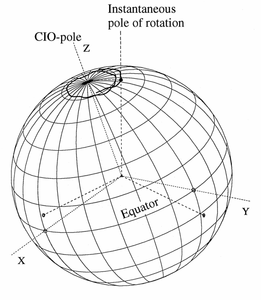
xp, yp: Pole coordinates or polar motion, represents the motion of the pole in the terrestrial system. The polar motion cannot be modelled; it is to be inferred from observations.
These time-dependent parameters describe the difference in orientation of GCRS and ITRS by means of,
[ x_{ITRS}=W(x_p,y_p,s’)R(ERA)Q(dX,dY,s) x_{GCRS} ]
s and s’ are small angular corrections specifying the celestial and terrestrial intermediate origins used in the transformation between the terrestrial and celestial reference systems. The axes directions of GCRS are obtained from the positions of extra galactic objects, whereas the axes directions of ITRS are determined from coordinates of reference points of stations of space geodetic techniques on the Earth surface.
International Earth Rotation and Reference Systems Service – IERS
In this context, the terminology of rotation pole or rotation axis is specific for the diurnal revolution of the Earth (ERA), excluding the remaining smaller components of the true angular velocity. The International Earth Rotation and Reference Systems Service (IERS) is responsible for disseminating the EOP time series on operational basis derived from space geodetic techniques, including VLBI, SLR, GNSS and DORIS provided by the corresponding IAG Services, i.e., IVS, ILRS, IGS and IDS. Highly accurate CPO and UT1 are exclusively obtained by VLBI, whereas the satellite-based techniques can provide polar motion, length of day (LOD) and their first time derivatives with high precision and temporal resolution. If a sufficient number of normal points is available, LLR will be able to provide UT1 with an accuracy comparable to the VLBI results. The satellite-based techniques can refer their observations to GCRS only indirectly, if the ascending node, perigee distance and inclination of the respective orbits are known.
Data Sources
- IERS: International Earth Rotation and Reference Systems Service (IERS)
- IERS Earth Orientation Centre: The IERS Earth Orientation Centre is responsible for monitoring long-term EOPs, publication of time dissemination information, and leap second announcements. It is located at the Observatoire de Paris in France.
- IERS Rapid Service/Prediction Centre: The IERS Rapid Service/Prediction Centre is responsible for providing predicted EOP and measured EOP with a rapid turnaround, primarily for real-time users and others needing EOP information quickly. It is located at the United States Naval Observatory (USNO) in Washington, D.C., USA.