Land, Marine and Absolute Gravity Data
What is the purpose of measuring gravity on the Earth’s surface?
The collection, homogenization and validation of all available gravity measurements acquired at or close to the Earth’s surface (e.g. airborne measurements) and their distribution to scientific users is an important task to improve the global knowledge of the Earth’s gravity field. Before the era of the satellite gravity missions CHAMP, GRACE, GRACE Follow-on and GOCE, the computation of the gravity field models was based primarily on terrestrial gravity measurements together with Satellite Laser Ranging (SLR) data. But even today, these terrestrial gravity measurements play a fundamental role for the validation of the results derived from the satellite gravity missions, and these data are indispensable for the computation of high-resolution gravity field models.

Land Gravity Data (LGD)
Land gravity data consists of gravity measurements obtained through land-based and airborne gravimetry. Land-based gravimetry involves measuring the local gravity field using instruments deployed on the Earth’s surface. These include relative gravimeters, absolute gravimeters and superconducting gravimeters. These observations are used to characterise subsurface mass distribution, detect temporal variations in terrestrial mass and contribute to establishing and maintaining high-precision geodetic reference networks. Airborne gravimetry measures the Earth’s gravity field from aircraft or helicopters, integrating gravimeter observations with GNSS positioning and inertial navigation systems. This technique enables regional variations in mass distribution and density to be mapped, supporting applications in geodesy, Earth sciences, and resource exploration. As measurements can be efficiently collected over extensive and difficult-to-access regions, airborne gravity surveys are an effective means of acquiring gravity data over large areas.
Marine Gravity Data (MGD)
Marine gravity data consists of gravity measurements derived from shipborne gravimetry. This technique involves observing the Earth’s gravity field from a moving vessel using specialised gravimeters, with corrections applied to account for the ship’s movement. These observations are crucial for mapping gravity variations in coastal and offshore areas, and are used in studies of the marine geophysical environment and in determining the oceanic gravity field.

Absolute Gravity Data (AGD)
Absolute gravity data: Gravity measurements can be classified as either absolute or relative, depending on the approach taken to make the measurement. Absolute gravimetry determines the actual value of gravitational acceleration at a specific location and time by directly measuring acceleration due to gravity. As length and time measurements are linked to traceable metrological standards, absolute gravimeters can directly determine the local gravity field (e.g. approximately 9.8xx xxx xx m/s²). State-of-the-art instruments can achieve an accuracy of around  , which corresponds to approximately one part per billion. In contrast, relative gravimetry measures gravity differences between two locations or temporal variations in gravity at a fixed site. Although they do not provide an absolute gravity value, relative gravimeters are highly sensitive and can detect changes in gravity with an accuracy comparable to that achieved by absolute instruments, reaching the parts-per-billion level. These measurements are widely used in land-, airborne- and shipborne-based gravimetry.
International Gravimetric Bureau
In 1951, the International Gravimetric Bureau (BGI) has been created as a scientific service of IAG (within the IGFS – International Gravity Field Service) for ensuring the collection, validation, archiving and distribution of the terrestrial gravity data to a large variety of users for scientific applications. The global databases of BGI include:
- land gravity data
- marine gravity data
- airborne gravity data
- absolute gravity data
- gravity observations at gravity reference stations
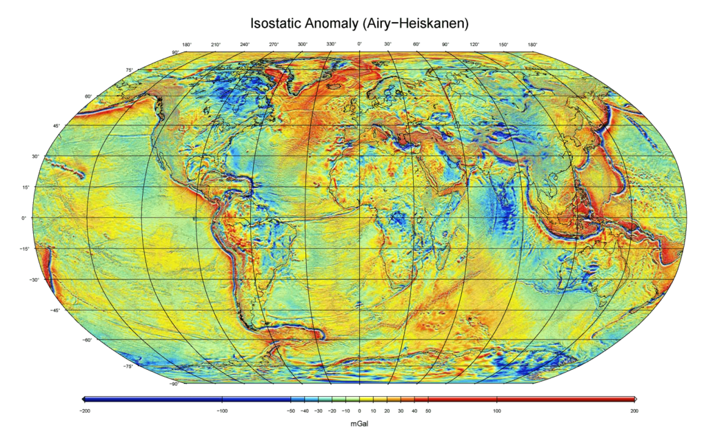
BGI also contributes to the realization of derived gravity products to support studies of the Earth gravity field at global and regional scales. This includes high-resolution grids and maps of Earth´s gravity anomalies of different kind and gravity anomaly grids computed from standard high-resolution gravity field models. Other services include online tools for predicting gravity at a given site, tools and software for data acquisition or validation, the attribution of digital object identifier (DOI) for gravity data sets, and various documentations (e.g., BGI data formats, gravity anomalies, absolute gravity data base, tutorials). BGI has its Central Bureau in Toulouse, France and operates with the support of various French agencies and universities. BGI services benefit also from a close collaboration of other agencies from Germany (BKG), Italy (POLIMI), Greece (AUTH), Czech Republic (VUGTK), Denmark (DTU) and USA (NGA).
Data Sources
Global Gravity Databases
Global or Regional Products
Other Services