• Link to LinkedIn
  • Link to Youtube
  • Link to Facebook
  • Link to Instagram
  • Link to X
  • Link to Telegram
  • Link to Behance
  • Link to Rss this site
  • Link to Mail
  • NEWS
  • EVENTS
  • JOBS
  • MEMBER
  • Sitemap
    • Home
      • NEWS
      • EVENTS
      • JOBS
      • MEMBERSHIP
    • ⭐ About Geodesy
    • 🏛️ IAG | International Association of Geodesy
      • About IAG
      • Structure
      • 🎓 ECS – Early Career Scientists
      • 🌈 IDEA – Inclusion, Diversity, Equity, Accessibility
    •   └─ Comissions
      • 1️⃣ Reference Frames
      • 2️⃣ Gravity Field
      • 3️⃣ Earth Rotation & Geodynamics
      • 4️⃣ Positioning & Applications
    •   └─ Inter Commission Committees
      • 📚 ICCT – Theory
      • 🌊 ICCM – Marine Research
      • 🌥️ ICCC – Climate Research
    •   └─ Project QuGe
    •   └─ Services
    • 🌍 GGOS | Global Geodetic Observing System
      • About GGOS
      • Structure
      • 🛰️ Observations
      • 📦 Products
      • ⚙️ Services
  • Shopping Cart Shopping Cart
    0Shopping Cart
geodesy.science - IAG website
  • GGOS
    • Home
      • NEWS
      • EVENTS
      • JOBS
      • MEMBERSHIP
    • ⭐ About Geodesy
    • 🏛️ IAG | International Association of Geodesy
      • About IAG
      • Structure
      • 🎓 ECS – Early Career Scientists
      • 🌈 IDEA – Inclusion, Diversity, Equity, Accessibility
    •   └─ Comissions
      • 1️⃣ Reference Frames
      • 2️⃣ Gravity Field
      • 3️⃣ Earth Rotation & Geodynamics
      • 4️⃣ Positioning & Applications
    •   └─ Inter Commission Committees
      • 📚 ICCT – Theory
      • 🌊 ICCM – Marine Research
      • 🌥️ ICCC – Climate Research
    •   └─ Project QuGe
    •   └─ Services
    • 🌍 GGOS | Global Geodetic Observing System
      • About GGOS
      • Structure
      • 🛰️ Observations
      • 📦 Products
      • ⚙️ Services
  • About
    • About GGOS
      • What is GGOS?
      • Why GGOS?
      • Dual Roles of GGOS
      • Vision and Mission
      • GGOS History
  • Structure
    • Governance & Leadership
      • Governing Board GB
      • Executive Committee EC
    • Coordinating Office CO
    • Science Panel
    • Bureaus
      • BNO – Networks and Observations
      • BPS – Products and Standards
    • Focus Areas
      • Geohazards Monitoring
      • Geodetic Space Weather Research
      • Artificial Intelligence for Geodesy (AI4G)
    • GGOS Affiliates
      • GGOS Japan
      • GGOS D-A-CH
      • GGOS IberAtlantic
    • GGOS Committees & Working Groups
  • Observations
  • Services
  • Products
  • EGV
  • Resources
    • Resources Overview
    • Outreach Materials
    • Logos & Organisation Chart
    • Reports and Articles
    • Presentations and Videos
    • GGOS Meeting Reports
    • Terms of Reference and Strategy
  • Click to open the search input field Click to open the search input field Search
Follow a manual added link

Ice Sheets

Ice Mass Change and Ice Sheet Thickness  Variations

Geodetic Product of EGV: Ice Sheets
How fast is the ice being lost in Greenland and Antarctica?

Ice sheets are vast continental-scale masses of glacial ice that cover more than 50,000 km². Today, only two ice sheets exist: the Antarctic Ice Sheet and the Greenland Ice Sheet. Unlike smaller glaciers that are confined by topography, ice sheets form broad dome-shaped structures and flow outward in all directions from their central accumulation areas under their own weight. They can completely bury the underlying landscape, covering mountains, valleys, and plains beneath thousands of metres of ice.

Temporal changes of the volume and mass of ice sheets are sensitive indicators of climate change, and strongly affect the global water cycle, surface energy budget, sea level change, ocean circulation patterns, and hence global climate. A precise monitoring of the behaviors of these ice bodies is essential for improved understanding of the Earth’s system, and interactions between its sub-components. Apart from this scientific motivation, these investigations are also highly relevant to society, since phenomena such as the global sea level rise are largely driven by accelerated melting of the Greenland and Antarctica ice sheets, and could be catastrophic for millions of people in the future.
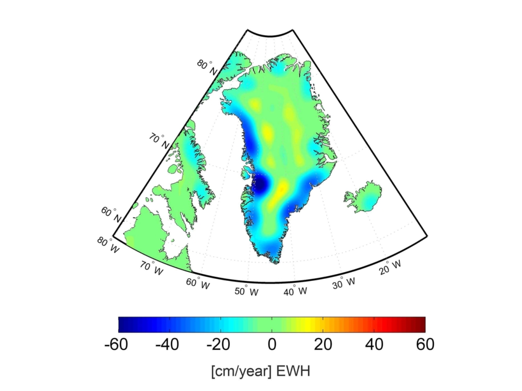
Greenland Ice
©Springer: Angermann et al. 2021, Book “Mission Erde”, German Edition, ISBN: 978-3-662-62337-4 Info Info
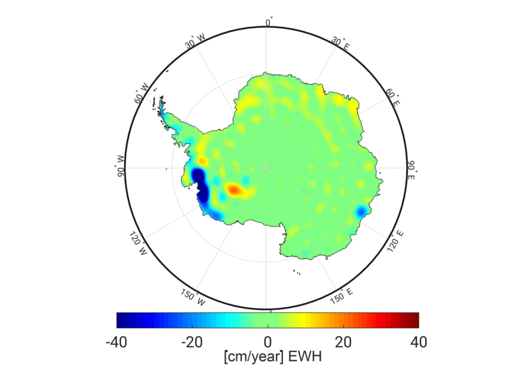
ICe Antarctica
©Springer: Angermann et al. 2021, Book “Mission Erde”, German Edition, ISBN: 978-3-662-62337-4 Info Info

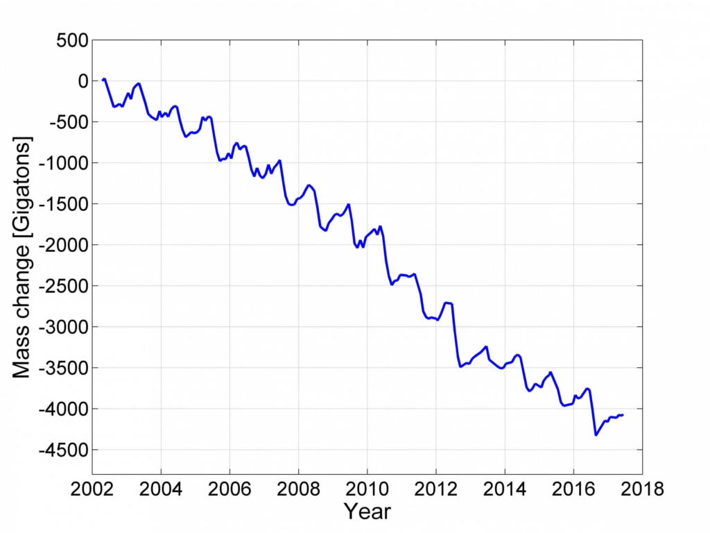
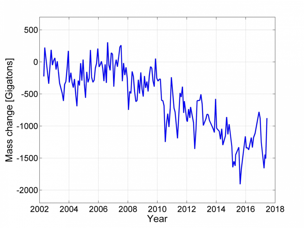
Changes of ice masses in Greenland (upper plots) and Antarctica (lower plots).

With observations from dedicated satellite gravity missions (CHAMP, GRACE, GRACE Follow-On, and GOCE), as well as remote sensing techniques from satellites and aircrafts, a precise monitoring of the mass and volume changes of the ice sheets is now possible. The three following methods are currently applied to measure the mass balance and volume changes of these ice bodies:

  • comparing net snow accumulation (assessed by atmospheric modeling) with ice discharge to the ocean by ice flow, assessed through measurements of flow velocities by interferometric SAR (InSAR);

Follow a manual added link

Ice Mass Change

using altimetry over the ice surface to measure changes of the thickness of ice sheets from radar (e.g., Cryosat) and laser (e.g., ICESat) altimeters (geometric method);

Follow a manual added link

Follow a manual added link

Ice Sheet Thickness

Measuring temporal gravity changes based on data from satellite gravity missions, directly providing estimates of mass change and mass transport (gravimetric method);

Both, the geometric and gravimetric methods require correction for changes in the elevation of rock beneath the ice. This is not necessary for the first method, which however relies on assessing the small difference between two large quantities, each with considerable uncertainty

The results obtained from the three different methods show a high level of agreements for the ice mass and volume changes (The IMBIE team, 2018 and 2020). The mass changes are shown for the Greenland and Antarctic ice sheets (see in top), derived from more than 15 years of GRACE data. In Greenland, the ice masses decrease significantly, particularly at the ice sheet margin. The time series shows a negative trend of ice masses in the order of almost 300 billion tons per year with a pronounced annual signal. The situation is different in Antarctica: There are regions in East Antarctica with an increase of ice masses, whereas the much larger mass loss in West Antarctica (primarily in the Amundsen Bay embayment) leads to an overall decrease of ice masses  of about 125 billion tons per year. From 2009, the time series for the mass changes in Antarctica shows an increased negative trend, which is mainly caused by mass loss in West Antarctica. The results do not show a clear annual signal and the estimates are less accurate than those of Greenland, since the required corrections for vertical crustal motions due to glacial isostatic adjustment (GIA) have a larger impact and the GIA models are less accurate (in Antarctica).

Data Sources

Data sets available at the European Space Agency (ESA)
  • Snow and ice classification and glacier monitoring

    with the ESA SAR mission Sentinel-1

  • Sea-ice and land ice thickness monitoring

    with the ESA altimetry mission Sentinel-3

  • Variations in the extent and thickness

    of the Earth’s continental ice sheets and polar sea ice with the ESA mission CryoSat-2 (Earth Explorer Opportunity Mission-2)

  • Brightness temperature, salinity contents and thin ice detection

    over oceans and soil moisture over land with the ESA interferometric radiometer mission SMOS (Soil Moisture and Ocean Salinity)

  • Level-3 data products

    provided by ESA’ Climate Change Initiative

  • Antarctic Ice Sheet, the Greenland Ice Sheet, Glaciers, and Sea Ice

    data products provided by the Copernicus Climate Change Service

Data sets available at the US National Aeronautics and Space Administration (NASA)
  • Cryosphere Data from ICESat-2

    Data and information on snow, sea ice, glaciers, ice sheets, ice shelves, frozen ground, soil moisture, cryosphere, and climate interactions derived from ICESat-2 (Ice, Cloud, and land Elevation Satellite – 2) and other satellite missions at the US National Snow and Ice Data Center as a Distributed Active Archive Center of the NASA

  • Microwave Radiometer Mission (SMAP)

    Brightness temperature, soil moisture and frozen/thawed ground status with the microwave radiometer mission of the NASA mission SMAP (Soil Moisture Active Passive)

  • Surface Heights of Ice Cover

    … in Greenland and the Antarctic and multi-year elevation data for ice sheet mass balance determination with the NASA missions ICESat (Ice, Cloud, and land Elevation Satellite) and ICESat-2

  • Ice Sheet Mass Loss

    Data products derived from NASA mission ICESat4

Further Information

  • The IMBIE team, Shepherd, A., Ivins, E. et al. Mass balance of the Antarctic Ice Sheet from 1992 to 2017. Nature 558, 219–222 (2018). https://doi.org/10.1038/s41586-018-0179-y

  • The IMBIE Team., Shepherd, A., Ivins, E. et al. Mass balance of the Greenland Ice Sheet from 1992 to 2018. Nature 579, 233–239 (2020). https://doi.org/10.1038/s41586-019-1855-2

© GGOS (Prepared by: D. Angermann, M. Horwarth, R. Pail, J. Chen, K. Heki)

view all cartoons

PRODUCTS

Global Reference Frames

  • Height Reference Frame
  • Celestial Reference Frame
  • Gravity Reference Frame
  • Terrestrial Reference Frame

Global Earth Gravity Field

  • Topographic Gravity Field Models
  • Global Gravity Field Quantities
  • Global Gravity Field Models

Earth Orientation Parameters

  • Earth Orientation Parameter Products

Satellite Orbits

  • GNSS Satellite Orbits, Clocks and Biases

Station Positions and Variations

  • Station Position Time Series

Atmosphere State / Atmosphere Parameters

  • Thermosphere Products
  • Ionosphere Products
  • Troposphere Products

Regional Reference Frames

  • Regional Height Reference Frame

Regional Gravity Field Model

  • Regional Gravity Field Quantities
  • Regional Geoid Models

Land and Marine Gravity Data

  • Time Series Gravity Data
  • Land, Marine and Absolute Gravity Data

Sea Surface

  • Mean Sea Surface

Sea Level

  • Relative Sea Level & Change
  • Global Sea Level
  • Global Sea Level Change

Sea Water Level Records

  • Sea Water Level Records

Sea Ice

Land Geometry

  • Earth’s Surface Deformation
  • Digital Elevation & Terrain Model

Inland Water Level

Terrestrial Water Storage

Ice Sheets

  • Ice Sheets

Glaciers

  • Glaciers

IAG as part of the IUGG

  
The International Association of Geodesy (IAG)  is a constituent association of the International Union of Geodesy and Geophysics (IUGG).

IAG Related Organisations

IAG collaborates closely with numerous organizations within geodesy and beyond. See the list for details.

Sitemap

  • Home | geodesy.science
  • ⠀└─ 📰News
  • ⠀└─ 📅 Events
  • ⠀└─ 💼 Jobs
  • ⠀└─ 👥 Membership
  • ⭐ About Geodesy
  • 🏛️ IAG | Int. Association of Geodesy
  • ⠀└─ ➡️ Commissions:
  • ⠀⠀◻️ 1 – Reference Frames
  • ⠀⠀◻️ 2 – Gravity Field
  • ⠀⠀◻️ 3 – Earth Rotation & Geodynamics
  • ⠀⠀◻️ 4 – Positioning and Applications
  • ⠀└─ 🔀 Inter Commission Committees:
  • ⠀⠀◻️ ICCT – Theory
  • ⠀⠀◻️ ICCM – Marine Research
  • ⠀⠀◻️ ICCC – Climate Research
  • ⠀└─ ⏰ Project QuGe
  • ⠀└─ ⚙️ IAG Services
  •  🌎 GGOS | Observing System
  • ⠀└─ About GGOS
  • ⠀└─ Structure
  • ⠀└─ Observations
  • ⠀└─ Products
  • ⠀└─ Services

References

Geodesy Glossary

Media Library

IAG Cloud | Public Documents

Terms of Use / Privacy Policy

IAG Statutes

IAG By-laws

Contact Us

Contact

Follow Us

LinkedIn

BlueSky

X (Twitter)

Facebook

Instagram

YouTube

Telegram

RSS Feed

Mailing List

This website is provided by the IAG Secretariat and the GGOS Coordinating Office, which are hosted by the BEV – Federal Office of Metrology and Surveying (Bundesamt für Eich- und Vermessungswesen) in Vienna, Austria.

Website Language Translation

The primary language of this website is English – however, the integrated GTranslate tool enables automatic translation into several languages:

Please note that translations into other languages may not be accurate. For reliable information, refer to the English version of the website.

2026 © Copyright | IAG - International Association of Geodesy
  • Link to LinkedIn
  • Link to Youtube
  • Link to Facebook
  • Link to Instagram
  • Link to X
  • Link to Telegram
  • Link to Behance
  • Link to Rss this site
  • Link to Mail
Scroll to top Scroll to top Scroll to top
Accessibility Adjustments

Powered by OneTap

How long do you want to hide the toolbar?
Hide Toolbar Duration
Select your accessibility profile
Vision Impaired Mode
Enhances website's visuals
Seizure Safe Profile
Clear flashes & reduces color
ADHD Friendly Mode
Focused browsing, distraction-free
Blindness Mode
Reduces distractions, improves focus
Epilepsy Safe Mode
Dims colors and stops blinking
Content Modules
Font Size

Default

Line Height

Default

Color Modules
Orientation Modules