

• Link to LinkedIn
  • Link to Youtube
  • Link to Facebook
  • Link to Instagram
  • Link to X
  • Link to Telegram
  • Link to Behance
  • Link to Rss this site
  • Link to Mail
  • NEWS
  • EVENTS
  • JOBS
  • MEMBER
  • Sitemap
    • Home
      • NEWS
      • EVENTS
      • JOBS
      • MEMBERSHIP
    • ⭐ About Geodesy
    • 🏛️ IAG | International Association of Geodesy
      • About IAG
      • Structure
      • 🎓 ECS – Early Career Scientists
      • 🌈 IDEA – Inclusion, Diversity, Equity, Accessibility
    •   └─ Comissions
      • 1️⃣ Reference Frames
      • 2️⃣ Gravity Field
      • 3️⃣ Earth Rotation & Geodynamics
      • 4️⃣ Positioning & Applications
    •   └─ Inter Commission Committees
      • 📚 ICCT – Theory
      • 🌊 ICCM – Marine Research
      • 🌥️ ICCC – Climate Research
    •   └─ Project QuGe
    •   └─ Services
    • 🌍 GGOS | Global Geodetic Observing System
      • About GGOS
      • Structure
      • 🛰️ Observations
      • 📦 Products
      • ⚙️ Services
  • Shopping Cart Shopping Cart
    0Shopping Cart
geodesy.science - IAG website
  • GGOS
    • Home
      • NEWS
      • EVENTS
      • JOBS
      • MEMBERSHIP
    • ⭐ About Geodesy
    • 🏛️ IAG | International Association of Geodesy
      • About IAG
      • Structure
      • 🎓 ECS – Early Career Scientists
      • 🌈 IDEA – Inclusion, Diversity, Equity, Accessibility
    •   └─ Comissions
      • 1️⃣ Reference Frames
      • 2️⃣ Gravity Field
      • 3️⃣ Earth Rotation & Geodynamics
      • 4️⃣ Positioning & Applications
    •   └─ Inter Commission Committees
      • 📚 ICCT – Theory
      • 🌊 ICCM – Marine Research
      • 🌥️ ICCC – Climate Research
    •   └─ Project QuGe
    •   └─ Services
    • 🌍 GGOS | Global Geodetic Observing System
      • About GGOS
      • Structure
      • 🛰️ Observations
      • 📦 Products
      • ⚙️ Services
  • About
    • About GGOS
      • What is GGOS?
      • Why GGOS?
      • Dual Roles of GGOS
      • Vision and Mission
      • GGOS History
  • Structure
    • Governance & Leadership
      • Governing Board GB
      • Executive Committee EC
    • Coordinating Office CO
    • Science Panel
    • Bureaus
      • BNO – Networks and Observations
      • BPS – Products and Standards
    • Focus Areas
      • Geohazards Monitoring
      • Geodetic Space Weather Research
      • Artificial Intelligence for Geodesy (AI4G)
    • GGOS Affiliates
      • GGOS Japan
      • GGOS D-A-CH
      • GGOS IberAtlantic
    • GGOS Committees & Working Groups
  • Observations
  • Services
  • Products
  • Resources
    • Resources Overview
    • Outreach Materials
    • Logos & Organisation Chart
    • Reports and Articles
    • Presentations and Videos
    • GGOS Meeting Reports
    • Terms of Reference and Strategy
  • Click to open the search input field Click to open the search input field Search
Follow a manual added link

Terrestrial

Reference Frame

Official IAG-GGOS Product icon
How can we provide a stable reference for measuring changes of our planet?

The International Association of Geodesy (IAG) recommends the International Terrestrial Reference Frame (ITRF) as the standard terrestrial reference frame for positioning, satellite navigation and Earth science applications, as well as for the definition and alignment of national and regional reference frames (see IAG Resolution No. 1, 2019). The importance of geodetic reference frames has been recognized by the United Nations, too. In February 2015, the UN General Assembly adopted its first geospatial resolution “A Global Geodetic Reference Frame for Sustainable Development”.

ITRF2020
© Altamimi et al., 2016 Info Info

ITRF station distribution [Source: Altamimi et al.]

The ITRF provides the fundamental basis to refer the geodetic observations and estimated parameters to a unified global basis. High accuracy, consistency and long-term stability are required for precisely monitoring global change phenomena as well as for precise positioning applications on and near the Earth’s surface. The ITRF comprises concrete points (markers) attached to the solid Earth crust with precisely determined coordinates (mean 3D positions of the stations and their motions).
Read More ...
ITRF
© Altamimi et al., 2016 Info Info

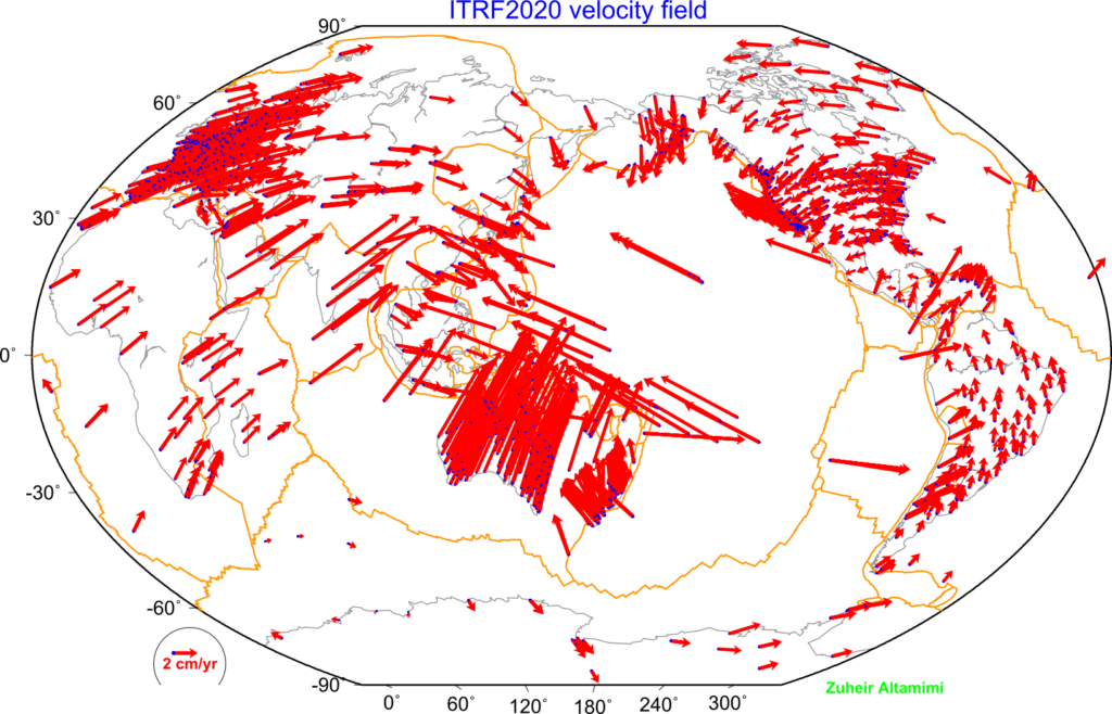
ITRF station horizontal velocities [Source: Altamimi et al.]

IERS – ITRS Centre

Within the International Earth Rotation and Reference Systems Service (IERS), the ITRS Centre (IGN, France) is responsible for the maintenance of the ITRS/ITRF, including network coordination, for providing the ITRS Combination Centers with specifications, and for evaluating their respective results. The ITRS Combination Centers are responsible to provide ITRF products by combining ITRF inputs from the Technique Centers and others. ITRS Combination Centers are currently maintained by IGN (Paris, France), DGFI-TUM (Munich, Germany) and JPL (Pasadena, USA).

The latest realization, the ITRF2020 has been released by the ITRS Center in 2022. The ITRF2020 is based on the input data time series of station positions and Earth Orientation Parameters (EOPs) provided by the Technique Centers (IGS; ILRS; IVS; IDS) of the four space geodetic techniques GNSS, SLR, VLBI and DORIS). The new ITRS realization, the ITRF2020 is currently under development and will be released by the ITRS Center at the end of 2021.

Regional Densifications of the ITRF

Regional densifications of the global ITRF providing coordinates and time series of additional terrestrial sites or points needed to provide access to the global reference frame anywhere on the Earth’s surface. Such regional reference frames are defined, generated and maintained under the responsibility of regional organizations:

  • Reference Frame Sub Commission for Europe (EUREF), IAG SC 1.3a
  • Geocentric Reference System for the Americas (SIRGAS), IAG SC 1.3b
  • North American Reference Frame (NAREF), IAG SC 1.3c
  • African Reference Frame (AFREF), IAG SC 1.3d
  • Asia-Pacific Reference Frame (APREF), IAG SC 1.3e
  • Scientific Committee on Antarctic Research (SCAR), IAG SC 1.3

Data Sources

  • ITRS Centre

    The ITRS Centre is responsible for the maintenance of the International Terrestrial Reference System (ITRS) and the International Terrestrial Reference Frame (ITRF). It is maintenanced by the IGN in France.

  • IERS

    International Earth Rotation and Reference Systems Service

Regional Densifications of the ITRF

  • EUREF - EPN (Regional Densification)

    The european regional densification is the EPN (Euorpean Permanent Network) and is coordinated by EUREF (http://euref.eu/).

  • SIRGAS (Regional Densification)

    Sistema de Referencia para las Américas

  • APREF (Regional Densification)

    Asia-Pacific Reference Frame

  • AFREF (Regional Densification)' class='iconlist_icon av-5b6vm5-b27705ba6f35b0af245af88192695364 avia-font-fontello-choosen avia-iconfont avia-font-fontello-choosen'>

    AFREF (Regional Densification)

    African Geodetic Reference Frame

  • NAREF (Regional Densification)' class='iconlist_icon av-3prelp-7cf4802a5613ca604a29dce00de31b48 avia-font-fontello-choosen avia-iconfont avia-font-fontello-choosen'>

    NAREF (Regional Densification)

    Regional Reference Frames for North America

  • SCAR

    Scientific Committee on Antarctic Research

Further Information

  • Altamimi, Z., Rebischung, P., Collilieux, X., Métivier, L., Chanard, K. (2023) ITRF2020: an augmented reference frame refining the modeling of nonlinear station motions. J Geod 97(47). https://doi.org/10.1007/s00190-023-01738-w

© GGOS (Prepared by: D. Angermann, Z. Altamimi, M. Rothacher, G. Blewitt, Kosuke Heki)

Share this Product

  • Facebook Facebook Share on Facebook
  • X-twitter X-twitter Share on X
  • Whatsapp Whatsapp Share on WhatsApp
  • Pinterest Pinterest Share on Pinterest
  • Linkedin Linkedin Share on LinkedIn
  • Mail Mail Share by Mail

PRODUCTS

Reference Frames

  • © TheNounProject (edited by GGOS)
    Height Reference Frame
  • ICRF celestial© TheNounProject (edited by GGOS)
    Celestial Reference Frame
  • © TheNounProject (edited by GGOS)
    Gravity Reference Frame
  • © TheNounProject (edited by GGOS)
    Terrestrial Reference Frame

Earth Orientation

  • EOP Earth orientation parameter© TheNounProject (edited by GGOS)
    Earth Orientation Parameters

Geometry

  • © TheNounProject (edited by GGOS)
    Surface Deformation Models
  • © TheNounProject (edited by GGOS)
    Ocean Topography Models
  • © TheNounProject (edited by GGOS)
    Sea Level Change
  • © TheNounProject (edited by GGOS)
    Digital Elevation Model
  • © TheNounProject (edited by GGOS)
    Ice Sheets & Glaciers – Variations
  • © TheNounProject (edited by GGOS)
    Station Positions & Variations
  • © TheNounProject (edited by GGOS)
    Tide Gauge Records
  • © TheNounProject (edited by GGOS)
    Sea Surface Heights

Gravity Field

  • © TheNounProject (edited by GGOS)
    Global Gravity Field – Models
  • © TheNounProject (edited by GGOS)
    Gravity Field – Temporal Variations
  • © TheNounProject (edited by GGOS)
    Terrestrial Gravity Data
  • © TheNounProject (edited by GGOS)
    Regional / Local Geoid Models
  • © TheNounProject (edited by GGOS)
    Ice Sheets & Glaciers – Variations
  • © TheNounProject (edited by GGOS)
    Height Systems

Positioning & Applications

  • ICON Atmosphere© TheNounProject (edited by GGOS)
    Thermosphere
  • ICON Atmosphere© TheNounProject (edited by GGOS)
    Ionosphere
  • ICON Atmosphere© TheNounProject (edited by GGOS)
    Lower Neutral Atmosphere
  • ICON Atmosphere© TheNounProject (edited by GGOS)
    Atmospheric Products
  • GNSS Orbits satellites GPS GLONASS Galileo BeiDou QZSS IRNSS© TheNounProject (edited by GGOS)
    GNSS Satellite Orbits and Clocks

IAG as part of the IUGG

  
The International Association of Geodesy (IAG)  is a constituent association of the International Union of Geodesy and Geophysics (IUGG).

IAG Related Organisations

IAG collaborates closely with numerous organizations within geodesy and beyond. See the list for details.

Sitemap

  • Home | geodesy.science
  • ⠀└─ 📰News
  • ⠀└─ 📅 Events
  • ⠀└─ 💼 Jobs
  • ⠀└─ 👥 Membership
  • ⭐ About Geodesy
  • 🏛️ IAG | Int. Association of Geodesy
  • ⠀└─ ➡️ Commissions:
  • ⠀⠀◻️ 1 – Reference Frames
  • ⠀⠀◻️ 2 – Gravity Field
  • ⠀⠀◻️ 3 – Earth Rotation & Geodynamics
  • ⠀⠀◻️ 4 – Positioning and Applications
  • ⠀└─ 🔀 Inter Commission Committees:
  • ⠀⠀◻️ ICCT – Theory
  • ⠀⠀◻️ ICCM – Marine Research
  • ⠀⠀◻️ ICCC – Climate Research
  • ⠀└─ ⏰ Project QuGe
  • ⠀└─ ⚙️ IAG Services
  •  🌎 GGOS | Observing System
  • ⠀└─ About GGOS
  • ⠀└─ Structure
  • ⠀└─ Observations
  • ⠀└─ Products
  • ⠀└─ Services

References

Geodesy Glossary

Media Library

IAG Cloud | Public Documents

Terms of Use / Privacy Policy

IAG Statutes

IAG By-laws

Contact Us

Contact

Follow Us

LinkedIn

BlueSky

X (Twitter)

Facebook

Instagram

YouTube

Telegram

RSS Feed

Mailing List

This website is provided by the IAG Secretariat and the GGOS Coordinating Office, which are hosted by the BEV – Federal Office of Metrology and Surveying (Bundesamt für Eich- und Vermessungswesen) in Vienna, Austria.

Website Language Translation

The primary language of this website is English – however, the integrated GTranslate tool enables automatic translation into several languages:

Please note that translations into other languages may not be accurate. For reliable information, refer to the English version of the website.

2026 © Copyright | IAG - International Association of Geodesy
  • Link to LinkedIn
  • Link to Youtube
  • Link to Facebook
  • Link to Instagram
  • Link to X
  • Link to Telegram
  • Link to Behance
  • Link to Rss this site
  • Link to Mail
Scroll to top Scroll to top Scroll to top
Accessibility Adjustments

Powered by OneTap

How long do you want to hide the toolbar?
Hide Toolbar Duration
Select your accessibility profile
Vision Impaired Mode
Enhances website's visuals
Seizure Safe Profile
Clear flashes & reduces color
ADHD Friendly Mode
Focused browsing, distraction-free
Blindness Mode
Reduces distractions, improves focus
Epilepsy Safe Mode
Dims colors and stops blinking
Content Modules
Font Size

Default

Line Height

Default

Color Modules
Orientation Modules

