
• Link to LinkedIn
  • Link to Youtube
  • Link to Facebook
  • Link to Instagram
  • Link to X
  • Link to Telegram
  • Link to Behance
  • Link to Rss this site
  • Link to Mail
  • NEWS
  • EVENTS
  • JOBS
  • MEMBER
  • Sitemap
    • Home
      • NEWS
      • EVENTS
      • JOBS
      • MEMBERSHIP
    • ⭐ About Geodesy
    • 🏛️ IAG | International Association of Geodesy
      • About IAG
      • Structure
      • 🎓 ECS – Early Career Scientists
      • 🌈 IDEA – Inclusion, Diversity, Equity, Accessibility
    •   └─ Comissions
      • 1️⃣ Reference Frames
      • 2️⃣ Gravity Field
      • 3️⃣ Earth Rotation & Geodynamics
      • 4️⃣ Positioning & Applications
    •   └─ Inter Commission Committees
      • 📚 ICCT – Theory
      • 🌊 ICCM – Marine Research
      • 🌥️ ICCC – Climate Research
    •   └─ Project QuGe
    •   └─ Services
    • 🌍 GGOS | Global Geodetic Observing System
      • About GGOS
      • Structure
      • 🛰️ Observations
      • 📦 Products
      • ⚙️ Services
  • Shopping Cart Shopping Cart
    0Shopping Cart
geodesy.science - IAG website
  • GGOS
    • Home
      • NEWS
      • EVENTS
      • JOBS
      • MEMBERSHIP
    • ⭐ About Geodesy
    • 🏛️ IAG | International Association of Geodesy
      • About IAG
      • Structure
      • 🎓 ECS – Early Career Scientists
      • 🌈 IDEA – Inclusion, Diversity, Equity, Accessibility
    •   └─ Comissions
      • 1️⃣ Reference Frames
      • 2️⃣ Gravity Field
      • 3️⃣ Earth Rotation & Geodynamics
      • 4️⃣ Positioning & Applications
    •   └─ Inter Commission Committees
      • 📚 ICCT – Theory
      • 🌊 ICCM – Marine Research
      • 🌥️ ICCC – Climate Research
    •   └─ Project QuGe
    •   └─ Services
    • 🌍 GGOS | Global Geodetic Observing System
      • About GGOS
      • Structure
      • 🛰️ Observations
      • 📦 Products
      • ⚙️ Services
  • About
    • About GGOS
      • What is GGOS?
      • Why GGOS?
      • Dual Roles of GGOS
      • Vision and Mission
      • GGOS History
  • Structure
    • Governance & Leadership
      • Governing Board GB
      • Executive Committee EC
    • Coordinating Office CO
    • Science Panel
    • Bureaus
      • BNO – Networks and Observations
      • BPS – Products and Standards
    • Focus Areas
      • Geohazards Monitoring
      • Geodetic Space Weather Research
      • Artificial Intelligence for Geodesy (AI4G)
    • GGOS Affiliates
      • GGOS Japan
      • GGOS D-A-CH
      • GGOS IberAtlantic
    • GGOS Committees & Working Groups
  • Observations
  • Services
  • Products
  • Resources
    • Resources Overview
    • Outreach Materials
    • Logos & Organisation Chart
    • Reports and Articles
    • Presentations and Videos
    • GGOS Meeting Reports
    • Terms of Reference and Strategy
  • Click to open the search input field Click to open the search input field Search
You are here: Home1 / IAG GGOS2 / GGOS Observations3 / GNSS Reflectometry
Follow a manual added link
Icon GGOS Observation Technique

GNSS Reflectometry

GNSS Reflectometry (GNSS-R) is a remote sensing technique, exploiting GNSS signals reflected from the Earth’s surface. A large variety of geophysical parameters can be monitored using GNSS-R measurements on different ground-based, airborne, and spaceborne platforms.

© GGOS (Created by Martin Sehnal) Info Info

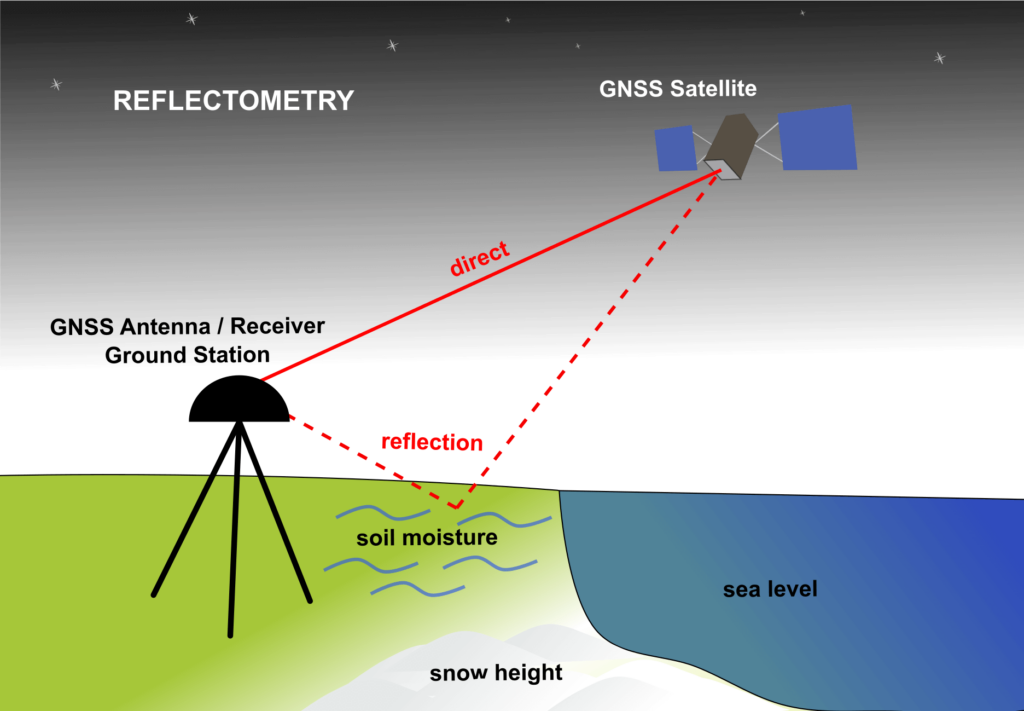
Figure 1: Principle of reflectometry using geodetic ground stations [Figure by M. Sehnal, ©GGOS]

Read More ...

GNSS-R with geodetic ground stations

The reflected signals from the surface cause patterns in GNSS measurements of geodetic ground stations (Figure 1). These patterns mainly appear when the GNSS satellite is near the horizon, i.e. at low elevation angles. The frequency and amplitude of these patterns are dependent on the surface state and can be therefore used to obtain information on e.g. sea level height, soil moisture, snow depth, and vegetation growth. It is consequently known that not only the existing GNSS signals but also existing GNSS networks, originally developed for geodetic applications, can be employed for such remote sensing purposes.
© GGOS (Created by Martin Sehnal) Info Info

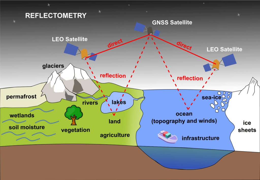
Figure 2. Principle of GNSS reflectometry using receivers on satellites. [Figure by M. Sehnal, ©GGOS]

GNSS-R with GNSS receivers on satellites

After several airborne experiments and pieces of evidence on the feasibility of tracking reflected signals onboard spaceborne platforms, the GNSS-R demonstration satellite missions, UK-DMC and TechDemoSat-1 were launched in 2003 and 2014 respectively. The receiver onboard these satellites cross correlated the reflected signal with a replica generated locally; this technique is known as conventional GNSS-R (cGNSS-R). The cross-correlation power was mapped in a range of delay and Doppler frequency shifts to create so-called delay-Doppler Maps (DDMs). The power in the DDMs and their shape are controlled by the type of reflecting medium and its properties. For instance, the inverse correlation of the power with ocean surface roughness, and consequently surface wind speed, motivated the main objective of NASA Cyclone GNSS (CYGNSS) launched in late 2016. CYGNSS is a constellation of eight microsatellites fully dedicated to GNSS-R for ocean surface and wind monitoring. The energy of GNSS L-band signals is insignificantly attenuated with raindrops and clouds in the atmosphere, which is the advantage taken by CYGNSS to observe tropical cyclones and hurricanes. The main goal of the first GNSS-R space missions was indeed the monitoring of ocean surface and wind state; i.e., ocean scatterometry. However, the spaceborne GNSS-R currently offers much varied applications, over not only ocean, but also over land and the cryosphere; and therefore, it plays a central role in their characterization and to infer relevant climate signals and possible natural hazards. The spaceborne measurements are additionally used for monitoring of e.g. soil moisture, sea level height, vegetation state, ice, and glaciers (Figure 2).
The implementation of GNSS-R requires only the receiver component which leads to competitive cost-effectiveness. The unprecedented sampling rate, due to the implementation onboard multiple-satellite constellations, encourages different ideas for a variety of applications. Several GNSS-R spaceborne missions are emerging with a variety of objectives and different observation concepts, e.g. cross-correlation of the reflected signal with that directly received, instead of the replica, known as interferometric GNSS-R (iGNSS-R). Further potentials are still being explored and the implementation of the technique onboard CubeSats is a recent promising development.

Further Information
  • ICCC - Inter-Commission Committee on Geodesy for Climate Research

    In the frame of the International Association of Geodesy (IAG), the Inter-Commission Committee on Geodesy for Climate Research (ICCC) leads present activities concentrated on advancing science and application of GNSS-R methods.

  • GFZ - GNSS Reflectometry

  • UCAR - GNSS Reflectometry

    UCAR – Constellation Observing System for Meteorology Ionosphere and Climate

  • Techdemosat 1 - Satellite Mission

  • CYGNSS - Satellite Mission Website

    CYGNSS – Cyclone Global Navigation Satellite System

    NASA JPL

  • CYGNSS - Satellite Mission Overview

© GGOS (Prepared by: J. Wickert, M. Asgarimehr, L. Sanchez, M. Sehnal)

Share

  • GNSS%20Reflectometry' data-av_svg_icon='facebook' data-av_iconset='svg_entypo-fontello' title='' data-avia-related-tooltip='Share on Facebook'> Facebook Facebook Share on Facebook
  • GNSS%20Reflectometry&url=https://geodesy.science/?p=9031' data-av_svg_icon='x-twitter' data-av_iconset='svg_entypo-fontello' title='' data-avia-related-tooltip='Share on X'> X-twitter X-twitter Share on X
  • Whatsapp Whatsapp Share on WhatsApp
  • GNSS%20Reflectometry&media=https%3A%2F%2Fgeodesy.science%2Fwp-content%2Fuploads%2Fggos-obs-GNSS-Occultation-Reflectometry-Scatterometry.svg' data-av_svg_icon='pinterest' data-av_iconset='svg_entypo-fontello' title='' data-avia-related-tooltip='Share on Pinterest'> Pinterest Pinterest Share on Pinterest
  • GNSS%20Reflectometry&url=https://geodesy.science/item/gnss-reflectometry/' data-av_svg_icon='linkedin' data-av_iconset='svg_entypo-fontello' title='' data-avia-related-tooltip='Share on LinkedIn'> Linkedin Linkedin Share on LinkedIn
  • GNSS%20Reflectometry&body=https://geodesy.science/item/gnss-reflectometry/' data-av_svg_icon='mail' data-av_iconset='svg_entypo-fontello' title='' data-avia-related-tooltip='Share by Mail'> Mail Mail Share by Mail

Geodetic Observations - Geodesy

Observation Types

  • GNSS Radio Occultation
  • Icon GGOS Observation Technique© TheNounProject
    VLBI
  • Icon GGOS Observation Technique© TheNounProject
    SLR / LLR – Laser Ranging
  • Icon GGOS Observation Technique© TheNounProject
    DORIS
  • Icon GGOS Observation Technique© TheNounProject
    GNSS
  • Icon GGOS Observation Technique© TheNounProject
    Satellite Altimetry
  • Icon GGOS Observation Technique© TheNounProject
    Satellite Gravimetry
  • Icon GGOS Observation Technique© TheNounProject
    Terrestrial Gravimetry
  • Icon GGOS Observation Technique© TheNounProject
    Tide Gauge Measurements
  • Icon GGOS Observation Technique© TheNounProject
    GNSS Reflectometry
  • Icon GGOS Observation Technique© TheNounProject
    Quantum Gravimetry
  • Icon GGOS Observation Technique© TheNounProject
    Optical Atomic Clocks
  • Icon GGOS Observation Technique
    GGOS Core Sites
Search Search

IAG as part of the IUGG

  
The International Association of Geodesy (IAG)  is a constituent association of the International Union of Geodesy and Geophysics (IUGG).

IAG Related Organisations

IAG collaborates closely with numerous organizations within geodesy and beyond. See the list for details.

Sitemap

  • Home | geodesy.science
  • ⠀└─ 📰News
  • ⠀└─ 📅 Events
  • ⠀└─ 💼 Jobs
  • ⠀└─ 👥 Membership
  • ⭐ About Geodesy
  • 🏛️ IAG | Int. Association of Geodesy
  • ⠀└─ ➡️ Commissions:
  • ⠀⠀◻️ 1 – Reference Frames
  • ⠀⠀◻️ 2 – Gravity Field
  • ⠀⠀◻️ 3 – Earth Rotation & Geodynamics
  • ⠀⠀◻️ 4 – Positioning and Applications
  • ⠀└─ 🔀 Inter Commission Committees:
  • ⠀⠀◻️ ICCT – Theory
  • ⠀⠀◻️ ICCM – Marine Research
  • ⠀⠀◻️ ICCC – Climate Research
  • ⠀└─ ⏰ Project QuGe
  • ⠀└─ ⚙️ IAG Services
  •  🌎 GGOS | Observing System
  • ⠀└─ About GGOS
  • ⠀└─ Structure
  • ⠀└─ Observations
  • ⠀└─ Products
  • ⠀└─ Services

References

Geodesy Glossary

Media Library

IAG Cloud | Public Documents

Terms of Use / Privacy Policy

IAG Statutes

IAG By-laws

Contact Us

Contact

Follow Us

LinkedIn

BlueSky

X (Twitter)

Facebook

Instagram

YouTube

Telegram

RSS Feed

Mailing List

This website is provided by the IAG Secretariat and the GGOS Coordinating Office, which are hosted by the BEV – Federal Office of Metrology and Surveying (Bundesamt für Eich- und Vermessungswesen) in Vienna, Austria.

Website Language Translation

The primary language of this website is English – however, the integrated GTranslate tool enables automatic translation into several languages:

Please note that translations into other languages may not be accurate. For reliable information, refer to the English version of the website.

2026 © Copyright | IAG - International Association of Geodesy
  • Link to LinkedIn
  • Link to Youtube
  • Link to Facebook
  • Link to Instagram
  • Link to X
  • Link to Telegram
  • Link to Behance
  • Link to Rss this site
  • Link to Mail
Scroll to top Scroll to top Scroll to top
Accessibility Adjustments

Powered by OneTap

How long do you want to hide the toolbar?
Hide Toolbar Duration
Select your accessibility profile
Vision Impaired Mode
Enhances website's visuals
Seizure Safe Profile
Clear flashes & reduces color
ADHD Friendly Mode
Focused browsing, distraction-free
Blindness Mode
Reduces distractions, improves focus
Epilepsy Safe Mode
Dims colors and stops blinking
Content Modules
Font Size

Default

Line Height

Default

Color Modules
Orientation Modules


