
News and Activities
GGOS IberAtlantic (GGOS IA) functions as a regional node of GGOS, focusing on geodetic activities across the Iberian Peninsula and the Atlantic region. GGOS IA fosters collaboration among geodetic institutions while promoting scientific research and technological development tailored to the region’s unique geophysical characteristics.




Welcome to the New IAG Website
BGI, Com1, Com2, Com3, Com4, Commissions, ECS, GGOS, IAG, ICCC, ICCM, ICCs, ICCT, ICGEM, IDEMS, IDS, IERS, IGETS, IGFS, IGS, ILRS, ISG, IVS, Project QuGe, Projects, PSMSL, Services, 📰 General NewsWe are excited to announce the official launch of the new IAG website geodesy.science. This launch marks a major milestone for the IAG and reflects our ambition to make geodesy more visible, accessible, and connected — both within the scientific community and beyond. We hope you enjoy the new site and invite you to explore it, share it, and help us continue to build a vibrant and open geodetic community.
🔎 Why geodesy.science?
The new domain geodesy.science clearly signals our core mission:
Whether you’re a geodesist or someone just discovering this field, the new website aims to welcome all audiences. The homepage is also designed for those unfamiliar with geodesy, and the new ⭐ About Geodesy section offers a modern, easy-to-understand overview of the field’s key themes and real-world impact. In addition, the GGOS section offers a clear overview and accessible explanations of 🛰️ geodetic observation techniques and the 📦 key geodetic products derived from them.
🧭 Easier Navigation, Clear Focus
The website has been built with user-friendliness in mind. It highlights four main areas to keep our community informed and connected:
🙋 Keep Community Informed – Share Your News, Events, Jobs with Us:
We invite everyone involved in geodesy to actively contribute and help us keep the community informed. You can now easily submit 📰 News, 📅 Events, and 💼 Job Offers via our convenient online submission forms, available directly on the respective pages. Let’s work together to showcase the relevance and importance of geodesy in today’s world.
🌍 Discover IAG Components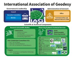
Curious to learn more about the different branches of the IAG? Just like geodesy itself, the IAG is multifaceted. Scientists from around the world come together under the IAG umbrella to advance the many dimensions of geodesy. Each area of expertise within geodesy is represented by a dedicated 🧑🤝🧑 IAG component and its many subcomponents. This website offers detailed information about all of them. Explore the components and discover how they contribute to shaping our understanding of the Earth!
🙏 Special Thanks
Last but not least, we would like to sincerely thank everyone who made this new website possible. In particularly our colleagues at
We also deeply appreciate everyone who kindly reviewed the site in advance and provided valuable feedback 🙏
A new atomic clock in space could help us measure elevations on Earth
Com1, Com2, GGOS, IGFS, ISG, Project QuGe, 🌍 Geodesy NewsWhat if we could measure height differences on Earth with centimeter level accuracy from space?
A new article from MIT Technology Review explores how the European Space Agency’s ACES mission (Atomic Clock Ensemble in Space), now installed on the International Space Station, could revolutionize global height measurements. The mission links ultra-precise atomic clocks in orbit with the best clocks on Earth, enabling scientists to refine our understanding of gravity and elevation.
Why does this matter? Because even today, elevation is not as straightforward as it seems. The Earth’s seas aren’t level, and inconsistent reference points have led to real world engineering issues, like a bridge over the Rhine that didn’t align correctly due to differing sea level baselines.
ACES could be a game changer. By comparing how time ticks differently under varying gravitational influences (thanks to Einstein’s general relativity), scientists can build a more precise model of the Earth’s geoid, the “level” surface from which elevation is measured. This is especially critical in regions like Africa and South America, where traditional gravity-based surveys have been limited.
The long-term goal? A global network of space-linked atomic clocks enabling consistent, centimeter-accurate elevation data everywhere on Earth. It helps geodesist to improve global height reference systems like the International Height Reference Frame down to the centimeter.
🔗 Read the full article here:
https://www.technologyreview.com/2025/05/22/1117294/a-new-atomic-clock-in-space-could-help-us-measure-elevations-on-earth/
Virtual School of Geodesy – Reference Frames, Geodynamics, Atmosphere
Com1, ECS, GGOS, IERS, Other, 📅 Event UpdateAre you passionate about geodesy, climate change, and the global systems that help us understand our planet? Don’t miss this unique opportunity to dive deep into one of the most relevant scientific topics of our time! This international online course is designed to explore the critical role of terrestrial reference frameworks in addressing environmental and climate-related challenges.
🎯 Course Objective: The objective of the 2025 School is to provide the most important concepts on the definition, implementation, and maintenance of global, continental, and national reference frameworks, as well as their importance in various applications. It will also address advances in Earth System monitoring in response to the challenges posed by climate change, which is already affecting us and impacting our most vulnerable societies.
📅 Course Dates:
🖥️ 100% Virtual – Join from anywhere in the world!
📺 Access: Session available on Zoom (after registration) or also streamed on SIRGAS YouTube Channel (once 500 seats are filled via Zoom)
🗣️ Languages: English and Spanish
🔗 Registration closed on May 24, 2025. But you can still watch it: