
Height Reference Frame (HRF)
What is a height above sea level?
A height system is a one-dimensional coordinate system used to express the metric distance (height) of a point above a reference surface (i.e., the zero-height level). Traditionally, the reference surface is linked to the mean sea level and the heights are determined using geodetic levelling techniques. These techniques measure the distance between two equipotential or level surfaces of the Earth’s gravity field and provide the height along the curved plumb line. The mean sea level serving as the zero-height level is inferred from averaged tide gauge records over certain time intervals and the heights are determined along the so-called vertical or levelling networks. As the tide gauges register the local sea level and the vertical networks cover limited regions, these systems are known as local height systems. Presently, there are about hundred local and regional height systems in use, and they exhibit discrepancies with respect to each other up to  2 m.
2 m.
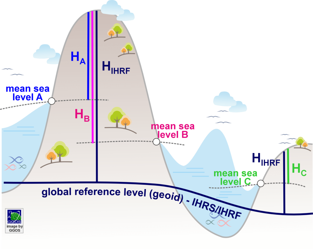
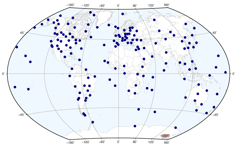
The International Height Reference System (IHRS) is a global unified height system: the zero-height level is a global equipotential surface of the Earth’s gravity field and the vertical coordinate of any point on the Earth’s surface is the level difference with respect to that global equipotential surface. Heights referring to the IHRS are consistent globally and do not depend on the local sea levels. The realisation of the IHRS is the International Height Reference Frame (IHRF): a set of reference stations homogeneously distributed over the world and with known geopotential numbers or height values referring to the IHRS.
A prominent example of the importance of the IHRS/IHRF is the recent height determination of Mount Everest in 2020. Referring this height to the Chinese height system (e.g.  in the figure above) or to the Nepalese height system (e.g.
  ) would produce different values, making difficult to decide which one is the appropriate one. To avoid discrepancies, the Chinese and Nepalese governments agreed to refer the new Mount Everest’s height to the IHRS/IHRF (e.g.
  ).
).
The International Height Reference System (IHRS)
The IHRS defines the equipotential surface of the Earth’s gravity field with the geopotential value  as the global reference level.
  is understood to be the gravity potential of the geoid or the geoidal potential value. The vertical coordinate is the geopotential number
  : the potential difference between the conventional reference value W0 and the potential
  of the Earth’s gravity field at a point
  . The spatial reference of the position P for the potential
  is given by the coordinate vector
  in the International Terrestrial Reference Frame (ITRF). Thus, the IHRS is founded on the combination of a geometric component given by
  and a physical component given by the determination of
  at . Coordinates of a point attached to the solid surface of the Earth include not only the station position
  and the geopotential number
  , but also the coordinate changes with time; i.e.,
  and
and  . For practical purposes, coordinates can be converted to ellipsoidal coordinates between latitude and
  ), longitude (
 ) and ellipsoidal height (
 ) and the geopotential numbers may be converted to a physical height (dynamic, orthometric or normal height).
The International Height Reference Frame (IHRF)
The definition of a reference system specifies the constants, conventions, models, and parameters required for the mathematical representation of geometric and physical quantities. A reference system is materialised by a reference frame in two ways: physically, by a solid materialisation of points or observing instruments, and mathematically, by the determination of coordinates related to this reference system. The coordinates of the points are calculated from the geodetic measurements according to the definition of the reference system. In this way, the realisation of the IHRS is the International Height Reference Frame (IHRF). The establishment of the IHRF is based on four main elements (Sánchez et al. 2021):
- A global set of reference stations with worldwide distribution, comprising (i) a core network to ensure the durability and long-term stability of the reference frame, and (ii) regional and national densifications to provide local accessibility to the global height system;
- A compilation of clear standards, conventions and procedures for the determination of the IHRF coordinates to ensure that the numerical values strictly follow the definition of the reference system;
- Computation of reference coordinates at the reference stations and guidelines for the densification of the IHRS at regional and national scales;
- An operational and organisational infrastructure (reference stations, data centres, analysis centres, combination centres, product centres, etc.) to ensure the maintenance and availability of the IHRF in the long term.
The main criteria for the selection of IHRF reference stations comprise:
- GNSS continuously operating reference stations to detect reference frame deformations (with preference for stations belonging to the ITRF and regional terrestrial reference frames);
- Co-location with fundamental geodetic observatories to ensure a consistent connection between geometric coordinates, potential and gravity values, and reference clocks;
- Co-location with reference stations of the International Terrestrial Gravity Reference Frame (ITGRF) to integrate the gravity and physical height reference frames;
- Co-location with reference tide gauges and connection to the national levelling networks to facilitate the transformation of the local height systems to the global one;
- Availability of terrestrial gravity data around the IHRF reference stations as a key requirement for high resolution gravity field modelling (i. e., precise estimation of potential values).
The core IHRF reference network consists of about 170 stations (see map above) and is currently being regularly refined in line with changes/updates of other geodetic reference frames (ITRF and ITGRF).
The International Height Reference Frame Coordination Centre (IHRF-CC)
The IHRF CC serves as the central coordinating body, dedicated to ensuring the maintenance, improvement, and global and long-term availability of the IHRS/IHRF. The IHRF-CC is part of the International Gravity Field Service (IGFS) of the International Association of Geodesy (IAG). The main activities of the IHRF-CC comprise:
- Maintain the IHRF reference network,
- Maintain a catalogue of conventions and standards required for the IHRS,
- Coordinate, validate and update the calculation of reference coordinates,
- Storage, metadata, management, and maintenance of potential values at IHRF stations and transformation parameters between the local and global height systems,
- Further development of the IHRS definition in accordance with future theoretical and technological improvements in gravity field modelling and precise positioning.