• Link to LinkedIn
  • Link to Youtube
  • Link to Facebook
  • Link to Instagram
  • Link to X
  • Link to Telegram
  • Link to Behance
  • Link to Rss this site
  • Link to Mail
  • NEWS
  • EVENTS
  • JOBS
  • MEMBER
  • Sitemap
    • Home
      • NEWS
      • EVENTS
      • JOBS
      • MEMBERSHIP
    • ⭐ About Geodesy
    • 🏛️ IAG | International Association of Geodesy
      • About IAG
      • Structure
      • 🎓 ECS – Early Career Scientists
      • 🌈 IDEA – Inclusion, Diversity, Equity, Accessibility
    •   └─ Comissions
      • 1️⃣ Reference Frames
      • 2️⃣ Gravity Field
      • 3️⃣ Earth Rotation & Geodynamics
      • 4️⃣ Positioning & Applications
    •   └─ Inter Commission Committees
      • 📚 ICCT – Theory
      • 🌊 ICCM – Marine Research
      • 🌥️ ICCC – Climate Research
    •   └─ Project QuGe
    •   └─ Services
    • 🌍 GGOS | Global Geodetic Observing System
      • About GGOS
      • Structure
      • 🛰️ Observations
      • 📦 Products
      • ⚙️ Services
  • Shopping Cart Shopping Cart
    0Shopping Cart
geodesy.science - IAG website
  • GGOS
    • Home
      • NEWS
      • EVENTS
      • JOBS
      • MEMBERSHIP
    • ⭐ About Geodesy
    • 🏛️ IAG | International Association of Geodesy
      • About IAG
      • Structure
      • 🎓 ECS – Early Career Scientists
      • 🌈 IDEA – Inclusion, Diversity, Equity, Accessibility
    •   └─ Comissions
      • 1️⃣ Reference Frames
      • 2️⃣ Gravity Field
      • 3️⃣ Earth Rotation & Geodynamics
      • 4️⃣ Positioning & Applications
    •   └─ Inter Commission Committees
      • 📚 ICCT – Theory
      • 🌊 ICCM – Marine Research
      • 🌥️ ICCC – Climate Research
    •   └─ Project QuGe
    •   └─ Services
    • 🌍 GGOS | Global Geodetic Observing System
      • About GGOS
      • Structure
      • 🛰️ Observations
      • 📦 Products
      • ⚙️ Services
  • About
    • About GGOS
      • What is GGOS?
      • Why GGOS?
      • Dual Roles of GGOS
      • Vision and Mission
      • GGOS History
  • Structure
    • Governance & Leadership
      • Governing Board GB
      • Executive Committee EC
    • Coordinating Office CO
    • Science Panel
    • Bureaus
      • BNO – Networks and Observations
      • BPS – Products and Standards
    • Focus Areas
      • Geohazards Monitoring
      • Geodetic Space Weather Research
      • Artificial Intelligence for Geodesy (AI4G)
    • GGOS Affiliates
      • GGOS Japan
      • GGOS D-A-CH
      • GGOS IberAtlantic
    • GGOS Committees & Working Groups
  • Observations
  • Services
  • Products
  • Resources
    • Resources Overview
    • Outreach Materials
    • Logos & Organisation Chart
    • Reports and Articles
    • Presentations and Videos
    • GGOS Meeting Reports
    • Terms of Reference and Strategy
  • Click to open the search input field Click to open the search input field Search
Follow a manual added link

Regional / Local

Geoid Models

Official IAG-GGOS Product icon
What is a geoid and why is it needed?

The geoid is the equipotential surface of the Earth’s gravity field that is closely approximated by the mean sea level, i.e. the surface of the sea in the absence of other influences such as winds and tides and so on. As an equipotential surface of the Earth’s gravity field, the geoid has important implications in engineering for the definition of physical heights and for Earth system studies. The most precise technique for determining physical heights above sea level is the classical levelling, but this method is very time consuming and expensive. Today, GNSS-levelling provides a very efficient technology to obtain ellipsoidal heights, from which physical heights can be computed. However, an indispensable requirement for the application of this new methodology is the precise knowledge of the geoid. This underlines the importance of the geoid also for a broad spectrum of surveying and engineering tasks based on the availability of physical heights.
© Reguzzoni et al., 2021 Info Info

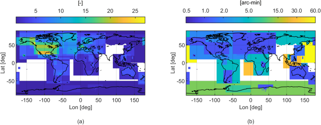
Geoid repository: (a) number of available geoid models covering the same area, where blank means missing data; (b) highest spatial resolution of the gridded geoid models available at ISG. [Reguzzoni et al., 2021]

Despite the remarkable improvements resulting from the satellite gravity missions CHAMP, GRACE, GRACE Follow-On, and GOCE, the derived global models are limited in terms of spatial resolution due to the dampening of the gravity signal at the satellites altitude. The use of ground, airborne and marine gravity data allows to refine and increase the spatial resolution of the geoid computed from global models. In general, geoid refinement is based on a variety of regional approaches solving a boundary value problem. Therefore, due also to historical reasons, many countries have their own regional or local geoid models.

Read More ...

The International Service for the GEOID

Already in 1992, IAG recognized the need for the establishment of a service to collect and redistribute regional/local geoid models at a worldwide scale, thus making them available to the user community. The International Service for the Geoid (ISG) was born as an IAG Service (formerly known as IGeS, International Geoid Service) within the International Gravity Field Service (IGFS). ISG manages and preserves an openly accessible repository, aiming at storing and redistributing geoid models in standardized data format, providing also ancillary information useful for the geoid application to further analyses. Most models can be freely downloaded, some of them require the author’s permission to be accessible and a few are restricted and cannot be distributed. Since 2020, ISG also provides the assignment of digital object identifiers (DOIs) to the stored geoid models. This is done in collaboration with GFZ Data Services, allowing geoid models being cited in publications.

The main products and tools of the ISG are:

  • Grids of local and regional geoid estimates, collected worldwide (geoid repository)
  • Software for local geoid estimation, terrain gravity effect calculation and global model handling
  • Organization of International schools on geoid determination and thematic courses
  • Publications on Newton’s Bulletin and the former IGeS Bulletin

Data Sources

  • ISG - Geoid Models Repository

    Repository of regional, national and continental geoid models at a worldwide scale at International Service for the Geoid (ISG)

Further Information

  • Geoid model specifications

  • Software

    for local geoid estimations

  • M. Reguzzoni, D. Carrion, C.I. De Gaetani, A. Albertella, L. Rossi, G. Sona, K. Batsukh, J.F. Toro Herrera, K. Elger, R. Barzaghi, and F. Sansó (2021). Open access to regional geoid models: the International Service for the Geoid. Earth System Science Data, 13(4), pp. 1653–1666. DOI: https://doi.org/10.5194/essd-13-1653-2021

© GGOS (Prepared by: D. Angermann, M. Reguzzoni, T. Gruber, Y. Tanaka)

Share this Product

  • Facebook Facebook Share on Facebook
  • X-twitter X-twitter Share on X
  • Whatsapp Whatsapp Share on WhatsApp
  • Pinterest Pinterest Share on Pinterest
  • Linkedin Linkedin Share on LinkedIn
  • Mail Mail Share by Mail

PRODUCTS

Reference Frames

  • © TheNounProject (edited by GGOS)
    Height Reference Frame
  • ICRF celestial© TheNounProject (edited by GGOS)
    Celestial Reference Frame
  • © TheNounProject (edited by GGOS)
    Gravity Reference Frame
  • © TheNounProject (edited by GGOS)
    Terrestrial Reference Frame

Earth Orientation

  • EOP Earth orientation parameter© TheNounProject (edited by GGOS)
    Earth Orientation Parameters

Geometry

  • © TheNounProject (edited by GGOS)
    Surface Deformation Models
  • © TheNounProject (edited by GGOS)
    Ocean Topography Models
  • © TheNounProject (edited by GGOS)
    Sea Level Change
  • © TheNounProject (edited by GGOS)
    Digital Elevation Model
  • © TheNounProject (edited by GGOS)
    Ice Sheets & Glaciers – Variations
  • © TheNounProject (edited by GGOS)
    Station Positions & Variations
  • © TheNounProject (edited by GGOS)
    Tide Gauge Records
  • © TheNounProject (edited by GGOS)
    Sea Surface Heights

Gravity Field

  • © TheNounProject (edited by GGOS)
    Global Gravity Field – Models
  • © TheNounProject (edited by GGOS)
    Gravity Field – Temporal Variations
  • © TheNounProject (edited by GGOS)
    Terrestrial Gravity Data
  • © TheNounProject (edited by GGOS)
    Regional / Local Geoid Models
  • © TheNounProject (edited by GGOS)
    Ice Sheets & Glaciers – Variations
  • © TheNounProject (edited by GGOS)
    Height Systems

Positioning & Applications

  • ICON Atmosphere© TheNounProject (edited by GGOS)
    Thermosphere
  • ICON Atmosphere© TheNounProject (edited by GGOS)
    Ionosphere
  • ICON Atmosphere© TheNounProject (edited by GGOS)
    Lower Neutral Atmosphere
  • ICON Atmosphere© TheNounProject (edited by GGOS)
    Atmospheric Products
  • GNSS Orbits satellites GPS GLONASS Galileo BeiDou QZSS IRNSS© TheNounProject (edited by GGOS)
    GNSS Satellite Orbits and Clocks

IAG as part of the IUGG

  
The International Association of Geodesy (IAG)  is a constituent association of the International Union of Geodesy and Geophysics (IUGG).

IAG Related Organisations

IAG collaborates closely with numerous organizations within geodesy and beyond. See the list for details.

Sitemap

  • Home | geodesy.science
  • ⠀└─ 📰News
  • ⠀└─ 📅 Events
  • ⠀└─ 💼 Jobs
  • ⠀└─ 👥 Membership
  • ⭐ About Geodesy
  • 🏛️ IAG | Int. Association of Geodesy
  • ⠀└─ ➡️ Commissions:
  • ⠀⠀◻️ 1 – Reference Frames
  • ⠀⠀◻️ 2 – Gravity Field
  • ⠀⠀◻️ 3 – Earth Rotation & Geodynamics
  • ⠀⠀◻️ 4 – Positioning and Applications
  • ⠀└─ 🔀 Inter Commission Committees:
  • ⠀⠀◻️ ICCT – Theory
  • ⠀⠀◻️ ICCM – Marine Research
  • ⠀⠀◻️ ICCC – Climate Research
  • ⠀└─ ⏰ Project QuGe
  • ⠀└─ ⚙️ IAG Services
  •  🌎 GGOS | Observing System
  • ⠀└─ About GGOS
  • ⠀└─ Structure
  • ⠀└─ Observations
  • ⠀└─ Products
  • ⠀└─ Services

References

Geodesy Glossary

Media Library

IAG Cloud | Public Documents

Terms of Use / Privacy Policy

IAG Statutes

IAG By-laws

Contact Us

Contact

Follow Us

LinkedIn

BlueSky

X (Twitter)

Facebook

Instagram

YouTube

Telegram

RSS Feed

Mailing List

This website is provided by the IAG Secretariat and the GGOS Coordinating Office, which are hosted by the BEV – Federal Office of Metrology and Surveying (Bundesamt für Eich- und Vermessungswesen) in Vienna, Austria.

Website Language Translation

The primary language of this website is English – however, the integrated GTranslate tool enables automatic translation into several languages:

Please note that translations into other languages may not be accurate. For reliable information, refer to the English version of the website.

2026 © Copyright | IAG - International Association of Geodesy
  • Link to LinkedIn
  • Link to Youtube
  • Link to Facebook
  • Link to Instagram
  • Link to X
  • Link to Telegram
  • Link to Behance
  • Link to Rss this site
  • Link to Mail
Scroll to top Scroll to top Scroll to top
Accessibility Adjustments

Powered by OneTap

How long do you want to hide the toolbar?
Hide Toolbar Duration
Select your accessibility profile
Vision Impaired Mode
Enhances website's visuals
Seizure Safe Profile
Clear flashes & reduces color
ADHD Friendly Mode
Focused browsing, distraction-free
Blindness Mode
Reduces distractions, improves focus
Epilepsy Safe Mode
Dims colors and stops blinking
Content Modules
Font Size

Default

Line Height

Default

Color Modules
Orientation Modules