

• Link to LinkedIn
  • Link to Youtube
  • Link to Facebook
  • Link to Instagram
  • Link to X
  • Link to Telegram
  • Link to Behance
  • Link to Rss this site
  • Link to Mail
  • NEWS
  • EVENTS
  • JOBS
  • MEMBER
  • Sitemap
    • Home
      • NEWS
      • EVENTS
      • JOBS
      • MEMBERSHIP
    • ⭐ About Geodesy
    • 🏛️ IAG | International Association of Geodesy
      • About IAG
      • Structure
      • 🎓 ECS – Early Career Scientists
      • 🌈 IDEA – Inclusion, Diversity, Equity, Accessibility
    •   └─ Comissions
      • 1️⃣ Reference Frames
      • 2️⃣ Gravity Field
      • 3️⃣ Earth Rotation & Geodynamics
      • 4️⃣ Positioning & Applications
    •   └─ Inter Commission Committees
      • 📚 ICCT – Theory
      • 🌊 ICCM – Marine Research
      • 🌥️ ICCC – Climate Research
    •   └─ Project QuGe
    •   └─ Services
    • 🌍 GGOS | Global Geodetic Observing System
      • About GGOS
      • Structure
      • 🛰️ Observations
      • 📦 Products
      • ⚙️ Services
  • Shopping Cart Shopping Cart
    0Shopping Cart
geodesy.science - IAG website
  • GGOS
    • Home
      • NEWS
      • EVENTS
      • JOBS
      • MEMBERSHIP
    • ⭐ About Geodesy
    • 🏛️ IAG | International Association of Geodesy
      • About IAG
      • Structure
      • 🎓 ECS – Early Career Scientists
      • 🌈 IDEA – Inclusion, Diversity, Equity, Accessibility
    •   └─ Comissions
      • 1️⃣ Reference Frames
      • 2️⃣ Gravity Field
      • 3️⃣ Earth Rotation & Geodynamics
      • 4️⃣ Positioning & Applications
    •   └─ Inter Commission Committees
      • 📚 ICCT – Theory
      • 🌊 ICCM – Marine Research
      • 🌥️ ICCC – Climate Research
    •   └─ Project QuGe
    •   └─ Services
    • 🌍 GGOS | Global Geodetic Observing System
      • About GGOS
      • Structure
      • 🛰️ Observations
      • 📦 Products
      • ⚙️ Services
  • About
    • About GGOS
      • What is GGOS?
      • Why GGOS?
      • Dual Roles of GGOS
      • Vision and Mission
      • GGOS History
  • Structure
    • Governance & Leadership
      • Governing Board GB
      • Executive Committee EC
    • Coordinating Office CO
    • Science Panel
    • Bureaus
      • BNO – Networks and Observations
      • BPS – Products and Standards
    • Focus Areas
      • Geohazards Monitoring
      • Geodetic Space Weather Research
      • Artificial Intelligence for Geodesy (AI4G)
    • GGOS Affiliates
      • GGOS Japan
      • GGOS D-A-CH
      • GGOS IberAtlantic
    • GGOS Committees & Working Groups
  • Observations
  • Services
  • Products
  • Resources
    • Resources Overview
    • Outreach Materials
    • Logos & Organisation Chart
    • Reports and Articles
    • Presentations and Videos
    • GGOS Meeting Reports
    • Terms of Reference and Strategy
  • Click to open the search input field Click to open the search input field Search
You are here: Home1 / IAG GGOS2 / GGOS Observations3 / InSAR
Follow a manual added link
Icon GGOS Observation Technique

Interferometric Synthetic Aperture Radar

InSAR

What is InSAR?

Interferometric Synthetic Aperture Radar (InSAR) is an Earth observation technique that uses repeated radar observations acquired by satellites to map topography and measure changes in the Earth’s surface over time. Since InSAR is an imaging technique, it creates dense spatial measurements with high detail over areas ranging from individual infrastructure sites to entire continents. By comparing radar images acquired over the same area at different times, InSAR can detect millimetre to centimetre-scale surface motion (ground deformation) and generate detailed digital elevation models. Unlike optical imaging systems, radar sensors operate day and night and can acquire observations through cloud cover, providing a reliable means of monitoring the dynamic Earth system.


How does InSAR work?

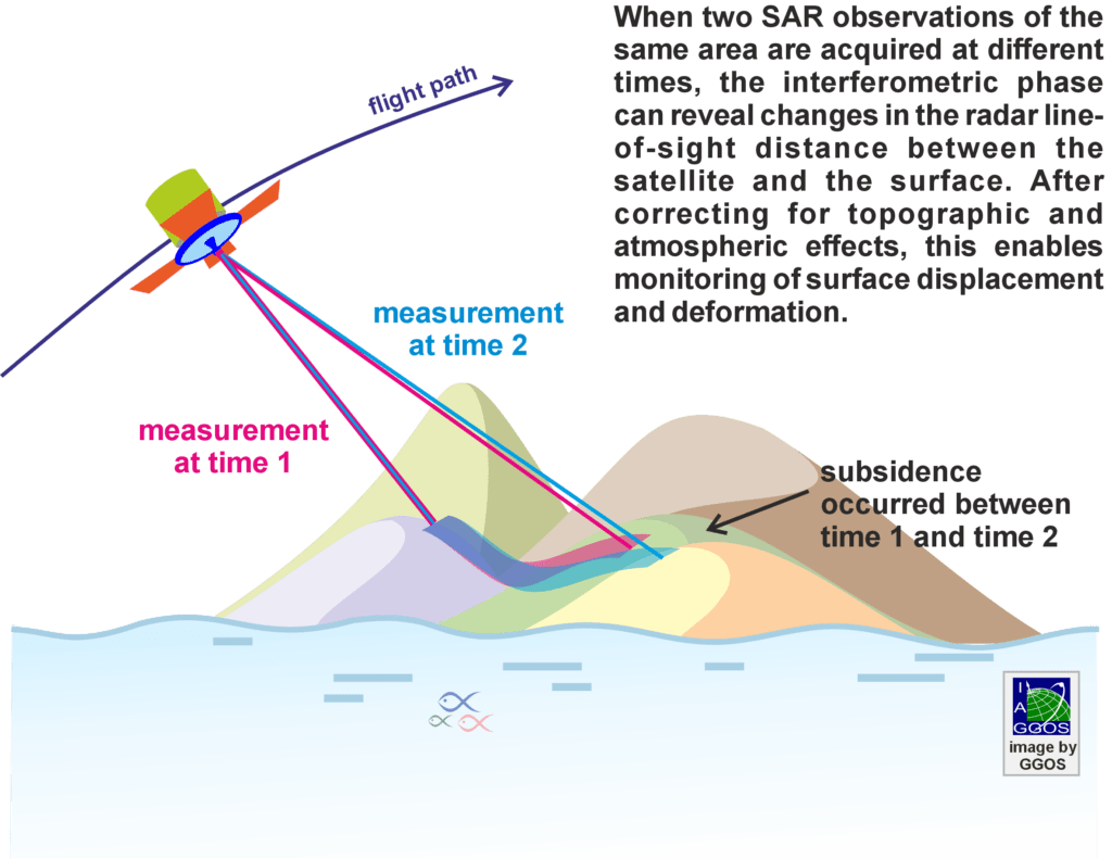
Radar instruments onboard satellites transmit microwave signals toward the Earth’s surface and record the reflected echoes. By comparing the phase of repeated radar acquisitions taken from nearly identical orbital positions, InSAR measures tiny changes-often just millimetres-in the distance between the satellite and the ground, measured along the satellite’s line of sight.
Importance for Geodesy

Within Global Geodetic Observing System, InSAR contributes a unique capability by providing dense spatial observations that complement the discrete point-based measurements delivered by terrestrial and space-geodetic techniques, such as Global Navigation Satellite Systems (GNSS). Together, these techniques contribute to monitoring Earth’s shape, deformation and dynamic processes while supporting realization and maintenance of terrestrial reference frames.

InSAR also relies on and benefits from dedicated ground-based geodetic infrastructure, including continuously operating GNSS stations, precisely surveyed reference points and radar calibration targets (such as corner reflectors and transponders), which support calibration, validation, quality assurance, geolocation accuracy and integration with terrestrial reference frames.

Unlike traditional geodetic techniques that provide highly accurate measurements at discrete locations, InSAR delivers millions of measurements over large areas, making it uniquely suited for mapping spatially continuous surface deformation.

Applications

InSAR is widely used to:

  • Measure crustal deformation associated with earthquakes, tectonic processes and volcanic activity.
  • Monitor land subsidence related to groundwater extraction, mining and urban development.
  • Generate digital elevation models and map topography.
  • Support natural hazard monitoring, including landslides and ground instability.
  • Support infrastructure monitoring, including buildings, bridges, railways, dams and other engineered structures.
  • Contribute to long-term observations of environmental and climate-related change.

© GGOS (Prepared by Faramarz Nilfouroushan, Matt Garthwaite, Laura Sánchez)

Geodetic Observations - Geodesy

Observation Types

  • GNSS Radio Occultation
  • Icon GGOS Observation Technique© TheNounProject
    VLBI
  • Icon GGOS Observation Technique© TheNounProject
    SLR / LLR – Laser Ranging
  • Icon GGOS Observation Technique© TheNounProject
    DORIS
  • Icon GGOS Observation Technique© TheNounProject
    GNSS
  • Icon GGOS Observation Technique© TheNounProject
    Satellite Altimetry
  • Icon GGOS Observation Technique© TheNounProject
    Satellite Gravimetry
  • Icon GGOS Observation Technique© TheNounProject
    Terrestrial Gravimetry
  • Icon GGOS Observation Technique© TheNounProject
    InSAR
  • Icon GGOS Observation Technique© TheNounProject
    Tide Gauge Measurements
  • Icon GGOS Observation Technique© TheNounProject
    GNSS Reflectometry
  • Icon GGOS Observation Technique© TheNounProject
    Quantum Gravimetry
  • Icon GGOS Observation Technique© TheNounProject
    Optical Atomic Clocks
  • Icon GGOS Observation Technique
    GGOS Core Sites
Search Search

IAG as part of the IUGG

  
The International Association of Geodesy (IAG)  is a constituent association of the International Union of Geodesy and Geophysics (IUGG).

IAG Related Organisations

IAG collaborates closely with numerous organizations within geodesy and beyond. See the list for details.

Sitemap

  • Home | geodesy.science
  • ⠀└─ 📰News
  • ⠀└─ 📅 Events
  • ⠀└─ 💼 Jobs
  • ⠀└─ 👥 Membership
  • ⭐ About Geodesy
  • 🏛️ IAG | Int. Association of Geodesy
  • ⠀└─ ➡️ Commissions:
  • ⠀⠀◻️ 1 – Reference Frames
  • ⠀⠀◻️ 2 – Gravity Field
  • ⠀⠀◻️ 3 – Earth Rotation & Geodynamics
  • ⠀⠀◻️ 4 – Positioning and Applications
  • ⠀└─ 🔀 Inter Commission Committees:
  • ⠀⠀◻️ ICCT – Theory
  • ⠀⠀◻️ ICCM – Marine Research
  • ⠀⠀◻️ ICCC – Climate Research
  • ⠀└─ ⏰ Project QuGe
  • ⠀└─ ⚙️ IAG Services
  •  🌎 GGOS | Observing System
  • ⠀└─ About GGOS
  • ⠀└─ Structure
  • ⠀└─ Observations
  • ⠀└─ Products
  • ⠀└─ Services

References

Geodesy Glossary

Media Library

IAG Cloud | Public Documents

Terms of Use / Privacy Policy

IAG Statutes

IAG By-laws

Contact Us

Contact

Follow Us

LinkedIn

BlueSky

X (Twitter)

Facebook

Instagram

YouTube

Telegram

RSS Feed

Mailing List

This website is provided by the IAG Secretariat and the GGOS Coordinating Office, which are hosted by the BEV – Federal Office of Metrology and Surveying (Bundesamt für Eich- und Vermessungswesen) in Vienna, Austria.

Website Language Translation

The primary language of this website is English – however, the integrated GTranslate tool enables automatic translation into several languages:

Please note that translations into other languages may not be accurate. For reliable information, refer to the English version of the website.

2026 © Copyright | IAG - International Association of Geodesy
  • Link to LinkedIn
  • Link to Youtube
  • Link to Facebook
  • Link to Instagram
  • Link to X
  • Link to Telegram
  • Link to Behance
  • Link to Rss this site
  • Link to Mail
Scroll to top Scroll to top Scroll to top
Accessibility Adjustments

Powered by OneTap

How long do you want to hide the toolbar?
Hide Toolbar Duration
Select your accessibility profile
Vision Impaired Mode
Enhances website's visuals
Seizure Safe Profile
Clear flashes & reduces color
ADHD Friendly Mode
Focused browsing, distraction-free
Blindness Mode
Reduces distractions, improves focus
Epilepsy Safe Mode
Dims colors and stops blinking
Content Modules
Font Size

Default

Line Height

Default

Color Modules
Orientation Modules

