• Link to LinkedIn
  • Link to Youtube
  • Link to Facebook
  • Link to Instagram
  • Link to X
  • Link to Telegram
  • Link to Behance
  • Link to Rss this site
  • Link to Mail
  • NEWS
  • EVENTS
  • JOBS
  • MEMBER
  • Sitemap
    • Home
      • NEWS
      • EVENTS
      • JOBS
      • MEMBERSHIP
    • ⭐ About Geodesy
    • 🏛️ IAG | International Association of Geodesy
      • About IAG
      • Structure
      • 🎓 ECS – Early Career Scientists
      • 🌈 IDEA – Inclusion, Diversity, Equity, Accessibility
    •   └─ Comissions
      • 1️⃣ Reference Frames
      • 2️⃣ Gravity Field
      • 3️⃣ Earth Rotation & Geodynamics
      • 4️⃣ Positioning & Applications
    •   └─ Inter Commission Committees
      • 📚 ICCT – Theory
      • 🌊 ICCM – Marine Research
      • 🌥️ ICCC – Climate Research
    •   └─ Project QuGe
    •   └─ Services
    • 🌍 GGOS | Global Geodetic Observing System
      • About GGOS
      • Structure
      • 🛰️ Observations
      • 📦 Products
      • ⚙️ Services
  • Shopping Cart Shopping Cart
    0Shopping Cart
geodesy.science - IAG website
  • GGOS
    • Home
      • NEWS
      • EVENTS
      • JOBS
      • MEMBERSHIP
    • ⭐ About Geodesy
    • 🏛️ IAG | International Association of Geodesy
      • About IAG
      • Structure
      • 🎓 ECS – Early Career Scientists
      • 🌈 IDEA – Inclusion, Diversity, Equity, Accessibility
    •   └─ Comissions
      • 1️⃣ Reference Frames
      • 2️⃣ Gravity Field
      • 3️⃣ Earth Rotation & Geodynamics
      • 4️⃣ Positioning & Applications
    •   └─ Inter Commission Committees
      • 📚 ICCT – Theory
      • 🌊 ICCM – Marine Research
      • 🌥️ ICCC – Climate Research
    •   └─ Project QuGe
    •   └─ Services
    • 🌍 GGOS | Global Geodetic Observing System
      • About GGOS
      • Structure
      • 🛰️ Observations
      • 📦 Products
      • ⚙️ Services
  • About
    • About GGOS
      • What is GGOS?
      • Why GGOS?
      • Dual Roles of GGOS
      • Vision and Mission
      • GGOS History
  • Structure
    • Governance & Leadership
      • Governing Board GB
      • Executive Committee EC
    • Coordinating Office CO
    • Science Panel
    • Bureaus
      • BNO – Networks and Observations
      • BPS – Products and Standards
    • Focus Areas
      • Geohazards Monitoring
      • Geodetic Space Weather Research
      • Artificial Intelligence for Geodesy (AI4G)
    • GGOS Affiliates
      • GGOS Japan
      • GGOS D-A-CH
      • GGOS IberAtlantic
    • GGOS Committees & Working Groups
  • Observations
  • Services
  • Products
  • EGV
  • Resources
    • Resources Overview
    • Outreach Materials
    • Logos & Organisation Chart
    • Reports and Articles
    • Presentations and Videos
    • GGOS Meeting Reports
    • Terms of Reference and Strategy
  • Click to open the search input field Click to open the search input field Search
Follow a manual added link

Time Series Gravity Data (TGD)

Geodetic Product of EGV: Land and Marine Gravity Data

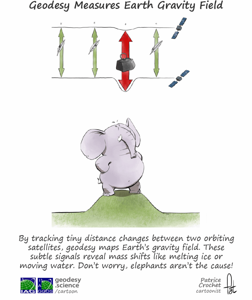
Time-series gravity data consist of sequential gravity measurements acquired over time to monitor temporal changes in the Earth’s gravity field. They are obtained from both global satellite missions and ground-based observation networks. Satellite missions such as GRACE, GRACE Follow-On (GRACE-FO), and the planned GRACE-C and Next Generation Gravity Mission (NGGM) observe large-scale mass redistribution processes, including ice-sheet mass loss, terrestrial water storage variations, and changes in ocean mass. Time series derived from these observations are distributed as time-variable gravity field models.

Ground-based gravity networks complement satellite observations by monitoring regional and local temporal gravity variations with significantly higher temporal resolution and sensitivity. These networks provide the highest-precision time-series gravity observations currently available, measuring local gravity variations with sub-microgal precision (approximately 10⁻⁹ m/s²). They are essential for validating satellite-derived gravity models and for capturing high-frequency gravity signals that cannot be resolved from space because of orbital altitude, spatial averaging, and temporal sampling limitations.

Ground gravity networks comprise continuously operating superconducting gravimeters, which provide uninterrupted records of relative gravity changes, together with repeated observations from absolute gravimeters, which establish long-term stability and absolute reference of the measurements.

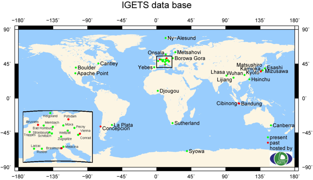
The International Geodynamics and Earth Tide Service (IGETS) of IAG’s International Gravity Field Service (IGFS) is the principal global infrastructure for monitoring temporal gravity variations. IGETS coordinates continuous, high-precision observations from approximately 68 superconducting gravimeters installed at 48 active stations worldwide. The service also contributes to the International Terrestrial Gravity Reference Frame (ITGRF), which integrates absolute gravity reference stations into a globally consistent realization of the Earth’s absolute gravity field.
IGETS data base network stations gravimetry gravity
© IGETS Info Info

Distribution of superconducting gravimeter stations (green: active stations, red: inactive stations)

The International Geodynamics and Earth Tides Service (IGETS)

IGETS collects, archives and distributes Earth tide records from long-term series from ground gravimeters, tiltmeters, strainmeters and other geodynamic sensors. IGETS has two analysis centers at the University of French Polynesia (Tahiti) and the University of Strasbourg (France). The main data center is hosted at GFZ Potsdam. The University of Strasbourg is also hosting the Central Bureau and a secondary data center. Further information is available at the IGETS overview page [link to https://geodesy.science/item/igets/] and IGETS website [link to http://igets.u-strasbg.fr/]

The main data products of IGETS are divided into raw and processed records from worldwide superconducting gravimeters. In particular, data at different processing levels provided at IGETS data base are:

  • Level-1: Raw gravity and local air pressure records sampled at 1 or 2 seconds, and/or resampled to 1-minute resolution;
  • Level-2: Gravity and local air pressure records corrected for instrumental perturbations, ready for tidal analysis;
  • Level-3: Gravity residuals after particular geophysical corrections, including solid Earth tides, polar motion, tidal and non-tidal loading effects. Individual data DOI are issued for Level 1 datasets by the IGETS data center.

Apart from these products, IGETS is also offering:

  • Superconducting gravimeter data for major earthquakes (minute and second sampling) – IGETS data;

and is supporting supplemental input data to process other main geodetic products:

  • Atmospheric attraction computation service Atmacs
  • Toolbox mGlobe for computing hydrological, atmospheric and non-tidal ocean loading effects
  • EOST loading service (displacements, gravity, tilts)

Data Sources
  • IGETS data base

    at the Information Systems and Data Center (ISDC) at GFZ Potsdam

  • EOST data base

    Data base of the School and Observatory of Earth Sciences (EOST)

© GGOS (Prepared by: D. Angermann, H. Wziontek, Y. Tanaka)

view all cartoons

PRODUCTS

Global Reference Frames

Celestial Reference Frame (CRF)Terrestrial Reference Frame (TRF)Gravity Reference Frame (GRF)Height Reference Frame (HRF)

Global Earth Gravity Field

Global Gravity Field Models (GGM)Topographic Gravity Field Models (TGFM)Global Gravity Field Quantities (GFQ)

Earth Orientation Parameters

Celestial Pole Offset (CPO)Universal Time (UT1)Length of Day (LOD)Polar Motion (PM)

Satellite Orbits

GNSS Satellite Orbits, Clocks and Biases (GOCB)Earth Observation Satellite Orbits (ESO)

Station Positions and Variations

Station Position Time Series (SPTS)

Atmosphere State

Products of the TroposphereProducts of the ThermosphereProducts of the Ionized Atmosphere

Regional Reference Frames

Regional Terrestrial Reference Frame (RTRF)Regional Gravity Reference Frame (RGRF)Regional Height Reference Frame (RHRF)Vertical Datum Parameter (VDP)

Regional Gravity Field Model

Regional Geoid Model (RGM)Regional Gravity Field Quantities (RGFQ)

Land and Marine Gravity Data

Land Gravity Data (LGD)Marine Gravity Data (MGD)Absolute Gravity Data (AGD)Time Series Gravity Data (TGD)

Sea Surface

Mean Sea Surface (MSS)Sea Level Anomaly (SLA)Sea State (SES)Empirical Ocean Tide Model (EOT)

Sea Level

Global Mean Sea Level / Mean Dynamic Topography (MSL/MDT)Global Sea Level Change / Dynamic Ocean Topography (SLC/DOT)Relative Mean Sea Level (RMSL)Relative Sea Level Change (RSLC)Mean Geostrophic Currents (MGC)

Sea Water Level Records

Sea Water Level Records (SWLR)

Sea Ice

Sea Ice Extension (SIE)Sea Ice Volume (SIV)

Land Geometry

Digital Elevation Model (DEM)Digital Terrain Model (DTM)Plate Kinematic Model (PKM)Earth Surface Deformation (ESD)

Inland Water Level

Mean Regional Water Level (MRWL)Regional Water Level Change (RWLC)

Terrestrial Water Storage

Terrestrial Water Storage Anomaly (TWSA)

Ice Sheets

Ice Mass Change (IMC)Ice Sheet Thickness (IST)

Glaciers

Glacier Mass Change (GMC)Glacier Ice Thickness (GIT)Glacier Flow Velocities (GFV)

IAG as part of the IUGG

  
The International Association of Geodesy (IAG)  is a constituent association of the International Union of Geodesy and Geophysics (IUGG).

IAG Related Organisations

IAG collaborates closely with numerous organizations within geodesy and beyond. See the list for details.

Sitemap

  • Home | geodesy.science
  • ⠀└─ 📰News
  • ⠀└─ 📅 Events
  • ⠀└─ 💼 Jobs
  • ⠀└─ 👥 Membership
  • ⭐ About Geodesy
  • 🏛️ IAG | Int. Association of Geodesy
  • ⠀└─ ➡️ Commissions:
  • ⠀⠀◻️ 1 – Reference Frames
  • ⠀⠀◻️ 2 – Gravity Field
  • ⠀⠀◻️ 3 – Earth Rotation & Geodynamics
  • ⠀⠀◻️ 4 – Positioning and Applications
  • ⠀└─ 🔀 Inter Commission Committees:
  • ⠀⠀◻️ ICCT – Theory
  • ⠀⠀◻️ ICCM – Marine Research
  • ⠀⠀◻️ ICCC – Climate Research
  • ⠀└─ ⏰ Project QuGe
  • ⠀└─ ⚙️ IAG Services
  •  🌎 GGOS | Observing System
  • ⠀└─ About GGOS
  • ⠀└─ Structure
  • ⠀└─ Observations
  • ⠀└─ Products
  • ⠀└─ Services

References

Geodesy Glossary

Media Library

IAG Cloud | Public Documents

Terms of Use / Privacy Policy

IAG Statutes

IAG By-laws

Contact Us

Contact

Follow Us

LinkedIn

BlueSky

X (Twitter)

Facebook

Instagram

YouTube

Telegram

RSS Feed

Mailing List

This website is provided by the IAG Secretariat and the GGOS Coordinating Office, which are hosted by the BEV – Federal Office of Metrology and Surveying (Bundesamt für Eich- und Vermessungswesen) in Vienna, Austria.

Website Language Translation

The primary language of this website is English – however, the integrated GTranslate tool enables automatic translation into several languages:

Please note that translations into other languages may not be accurate. For reliable information, refer to the English version of the website.

2026 © Copyright | IAG - International Association of Geodesy
  • Link to LinkedIn
  • Link to Youtube
  • Link to Facebook
  • Link to Instagram
  • Link to X
  • Link to Telegram
  • Link to Behance
  • Link to Rss this site
  • Link to Mail
Scroll to top Scroll to top Scroll to top
Accessibility Adjustments

Powered by OneTap

How long do you want to hide the toolbar?
Hide Toolbar Duration
Select your accessibility profile
Vision Impaired Mode
Enhances website's visuals
Seizure Safe Profile
Clear flashes & reduces color
ADHD Friendly Mode
Focused browsing, distraction-free
Blindness Mode
Reduces distractions, improves focus
Epilepsy Safe Mode
Dims colors and stops blinking
Content Modules
Font Size

Default

Line Height

Default

Color Modules
Orientation Modules