Global Mean Sea Level and
Mean Dynamic Topography
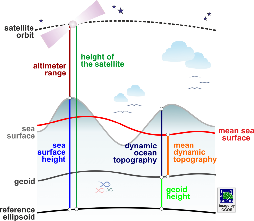
The height of the instantaneous ocean surface above the geoid (the Earth’s gravity equipotential surface that approximates the ocean surface at rest) is known as Dynamic Ocean Topography (DOT).DOT contains contributions from wind and other high frequency effects like tides, currents, and the loading of atmospheric pressure. DOT is also known as Absolut Dynamic Topography (ADT) or Ocean Surface Topography (OST).
Mean Dynamic Topography (MDT) is the averaged dynamic ocean topography over a time period and it is considered semi-stationary. It corresponds to the ocean relief (therefor, it is also called Sea Surface Topography – SSTop) and the gradient is related to the time-mean surface geostrophic circulation. It is also related to upper ocean density (temperature and salinity) as well as the time-mean currents.
Global Mean Sea Level (GMSL) represents the spatial average of sea surface height over the global ocean, derived from satellite altimetry observations after applying the standard geophysical and instrumental corrections (e.g., tides and atmospheric effects). It is the primary indicator used to monitor long-term changes in global sea level and assess sea level rise. GMSL can be expressed in two equivalent ways: (1) as the global average of sea surface height referenced to a reference ellipsoid, or (2) as the global average of the sum of the geoid height and the DOT. Since the geoid evolves slowly on climate time scales, apart from relatively small changes caused by mass redistribution within the Earth system, most of the temporal variability in GMSL can be attributed to changes in the ocean surface, as represented by variations in DOT.

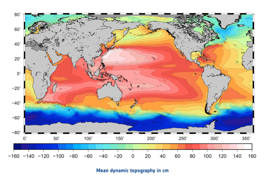
Dynamic ocean topography models are usually provided in regular grids. They are derived from the sea surface heights measured with satellite altimeters and global geoid models of high precision. The original altimetry data measured by the individual satellite altimetry missions are provided by the responsible space agencies. Some of them also provide pre-processed sea surface heights (so-called Level-3 or Level-4 products). Refined solutions are computed by different agencies, universities and research institutes, who provide their results in grids of few minutes of arc. These products differ with respect to the used data sets, the considered time span, and the processing strategies and methods. Global geoid models are provided by the International Centre for Global Gravity Field Models (ICGEM).
Selected Data Sources
- Radar Altimetry Tutorial and Toolbox: at the European Space Agency (ESA) and Centre National d’Etudes Spatiales (CNES)
- Ocean Surface Topography from Space: at the US National Aeronautics and Space Administration (NASA)
- AVISO+ satellite altimetry data: at the Centre National d’Etudes Spatiales (CNES) and the Center for Topographic studies of the Ocean and Hydrosphere (CTOH)
- Altimetric and Ocean Surface Topography: Data Information at the US National Aeronautics and Space Administration (NASA) and National Oceanic and Atmospheric Administration (NOAA)
- Copernicus: European Union’s Earth Observation Programme Copernicus
- ICGEM: International Centre for Global Gravity Field Models (ICGEM)