Regional Height Reference Frames
Regional Height Reference Frames
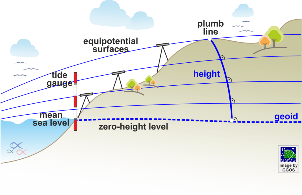
A height system is a one-dimensional coordinate system used to express the metric distance (height) of a point above a reference surface (i.e., the zero-height level) along a well-defined path. A height system is materialized by a height refence frame through a set of well-defined fiducial points with known precise heights, enabling the height system to be applied in practice. Usually, heights are determined by means of geodetic levelling techniques that measure the distance between two equipotential or level surfaces of the Earth’s gravity field and provide the height along the curved plumb line. As the height determination depends on the level surfaces and the plumb line of Earth’s gravity field, these systems are called physical height systems. The physical heights are referred to the geoid, a particular equipotential surface of the Earth’s gravity field that is close to the mean sea level. From the practical point of view, the mean sea level has been assumed as the zero-height level and inferred from averaged tide gauge records over certain time intervals. Since the mean sea level differs from the geoid (up to 2 m at global scale) and from point to point, the heights determined along the so- called vertical or levelling networks referred to a given tide gauge define a regional (local or national) height system and realize a regional (local or national) height reference frame. Presently, more than 100 regional height reference frames are in use.
Physical and geometric heights
The traditional way to obtain physical heights is geodetic levelling in combination with gravity reductions along the vertical or levelling networks. The gravity reductions are necessary to take into account the non-constant separation between equipotential surfaces due to variations of the Earth’s gravity field. Depending on the gravity correction applied to levelling, different types of physical heights are distinguished: orthometric heights, normal heights, or dynamic heights. Thus, the height of a point can be determined in many slightly different ways, each of which gives a different height coordinate for the same point.
Orthometric (H) and normal (H*) heights are widely used in the definition and realization of regional height systems, while dynamic heights are mainly employed to define the height coordinate in water bodies (e.g., large lakes). Physical height systems based on orthometric heights use the geoid (N) as reference surface. The geoid is the equipotential surface that best fits the mean sea level. Physical height systems based on normal heights use the quasi-geoid ( ) as reference surface. The quasi-geoid is close to the geoid but not an equipotential surface as the geoid is. The quasi-geoid deviates from the geoid in the same way as the normal heights deviate from the orthometric heights. They present differences on the millimetre to centimetre order at low elevations and may reach 1 m deviation in high mountains. On the oceans, geoid and quasi-geoid as well as orthometric and normal heights practically coincide.
Satellite positioning techniques like GNSS (Global and Navigation Satellite Systems) also allow the determination of heights. In this case, the reference surface is a reference ellipsoid, and the vertical coordinate is the ellipsoidal height. Since they do not depend on the Earth’s gravity field, the height system is called geometric height system. Geometric (or ellipsoidal) heights ( ) can be transformed into physical heights (
 or
or  ) using a geoid (
 ) or quasi-geoid () model:
![\[ h = H + N \approx H^{*} + \zeta \]](https://geodesy.science/wp-content/ql-cache/quicklatex.com-69450e5b8d866f22a8370c580b2d6156_l3.png "Rendered by QuickLaTeX.com")
Data Sources